Mountains & hills · Scottish Highlands
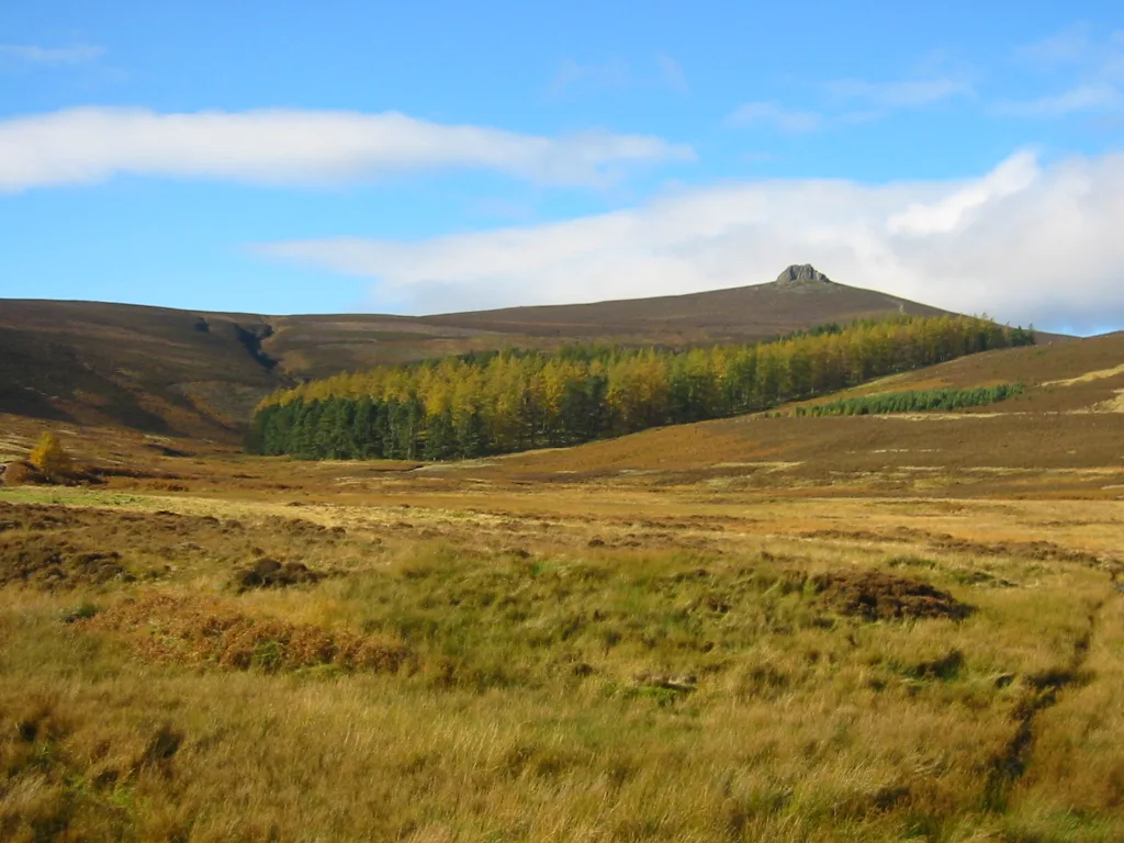
Clachnaben
Also known as: Clach na Beinne
Clachnaben — Named summit at 579 m.

Wikimedia Commons contributors — see linked file page for photographer and licence licence
Plan your visit
- Typical visit
- 3 h–8 h
- Best time of year
- Late spring – early autumn (May–Oct)
- Free entry
- Dog-friendly
About
Clachnaben is a named summit in the United Kingdom. Wikidata describes it as: "Named summit at 579 m.". Coordinates: 56.9685°, -2.6364°.
Photo gallery
From the Wikipedia article
Clachnaben (archaically "Cloch-na'bain"; Scottish Gaelic: "Clach na Beinne") is a 589-metre hill in Glen Dye, Aberdeenshire, Scotland. It is a distinctive hill visible from many points on Lower Deeside and is topped with a large granite tor. Clachnaben is the war cry of Clan Strachan. The hill gives its name to one of the houses at Aboyne Academy.
Excerpt from Wikipedia under CC BY-SA 4.0. See the source article linked in Sources below.
- Coordinates
- 56.9685, -2.6364
- Address
- Aberdeenshire, Scotland
Sources
- osm: n2216858243 (ODbL)
- wikipedia: Clachnaben (CC BY-SA 4.0)
- commons: Clachnaben.jpg (CC BY-SA 4.0)
Other places nearby
Loading nearby places…
Nearby
 📷 3
📷 3Natural landmarks · Scottish Highlands
Clachnaben
Clachnaben — mountain in Aberdeenshire, Scotland, UK.
 📷 5
📷 5Mountains & hills · Scottish Highlands
Mount Shade
Mount Shade — a hill or mountain in scotland highlands.
📷 5Mountains & hills · Scottish Highlands
Mount Shade
Mount Shade — mountain in scotland highlands. Elevation: 507 m.
 📷 5
📷 5Mountains & hills · Scottish Highlands
Sandy Hill
Sandy Hill — a hill or mountain in scotland highlands.
 📷 5
📷 5Mountains & hills · Scottish Highlands
Hill of Badymicks
Hill of Badymicks — mountain in scotland highlands. Elevation: 580 m.
 📷 5
📷 5Historic bridges · Scottish Highlands
Old bridge of Dye
Old bridge of Dye — category A listed building-listed bridge in scotland-highlands, United Kingdom.
Where to eat & stay near Clachnaben
Places to stay
 📷 5
📷 5Caravan parks · Scottish Highlands
Silver Ladies Caravan Park
Silver Ladies Caravan Park — a caravan park in scotland highlands.
 📷 5
📷 5Hotels · Scottish Highlands
Tor-na-Coille Hotel
Tor-na-Coille Hotel — a hotel in scotland highlands.
 📷 5
📷 5Caravan parks · Scottish Highlands
Banchory Lodge Caravan Park
Banchory Lodge Caravan Park — a caravan park in scotland highlands.
 📷 5
📷 5Hotels · Scottish Highlands
Banchory Lodge Hotel & Restaurant
Banchory Lodge Hotel & Restaurant — a hotel in scotland highlands.
 📷 5
📷 5Caravan parks · Scottish Highlands
Silverbank Caravan Club Site
Silverbank Caravan Club Site — a caravan park in scotland highlands.
 📷 5
📷 5Campsites · Scottish Highlands
Glenesk Caravan Park
Glenesk Caravan Park — a campsite in scotland highlands.
Places to eat & drink
 📷 5
📷 5Historic pubs · Scottish Highlands
Burnett Arms Hotel, High Street, Banchory
Burnett Arms Hotel, High Street, Banchory in Scotland Highlands, United Kingdom.
 📷 5
📷 5Historic pubs · Scottish Highlands
Learney Arms Hotel, The Square, Torphins
Learney Arms Hotel, The Square, Torphins in Scotland Highlands, United Kingdom.
More mountains in this region
 📷 3
📷 3Mountains & hills · Scottish Highlands
A' Bhuidheanach Bheag
A' Bhuidheanach Bheag — Named summit at 936 m.
 📷 3
📷 3Mountains & hills · Scottish Highlands
A' Chailleach
A' Chailleach — Named summit at 997 m.
 📷 3
📷 3Mountains & hills · Scottish Highlands
A' Chailleach
A' Chailleach — Named summit at 930 m.
 📷 3
📷 3Mountains & hills · Scottish Highlands
A' Chaoirnich
A' Chaoirnich — Named summit at 875 m.
Frequently asked questions
- Where is Clachnaben?
- Clachnaben is in the Scottish Highlands, United Kingdom.
- What is Clachnaben?
- Clachnaben — Named summit at 579 m.
- How do I get to Clachnaben?
- Its coordinates are 56.9685°, -2.6364°.
- Is Clachnaben free to visit?
- Yes, Clachnaben is free to enter.