
Historic churches · South West England
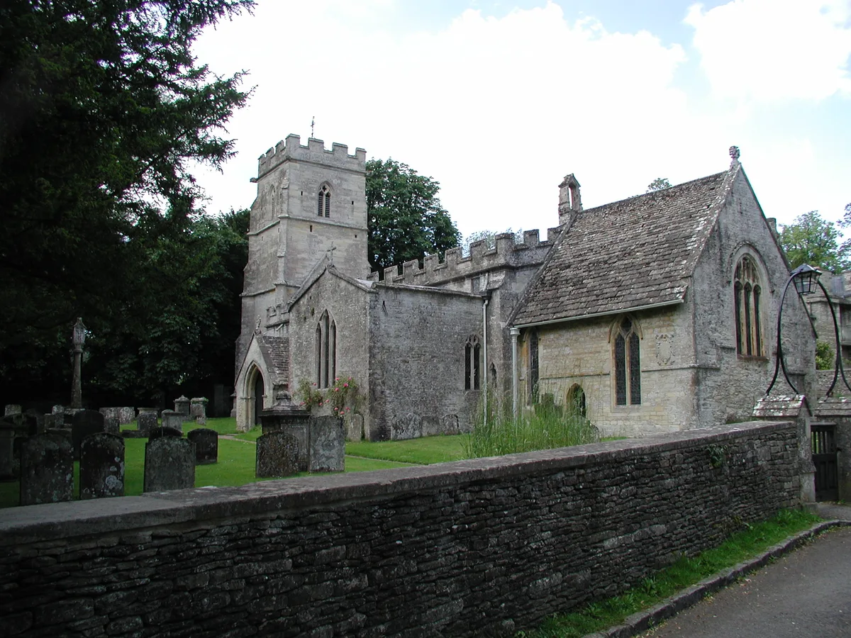
Church of St Mary
In or near Meysey Hampton.
Church of St Mary — church in Ampney, Cotswold District, United Kingdom.

Wikimedia Commons contributors — see linked file page for photographer and licence licence

Plan your visit
- Typical visit
- 30 min–1 h
- Nearest railway station
- Kemble · 9.9 km
- Free entry
Getting there & planning your visit
The Church of St Mary is located in the Forest of Dean, Gloucestershire, with the postcode GL2 8DT. The nearest railway station is Kemble, which is 9.9 km away. Entry to the church is free.
About
Church of St Mary is a historic church in the United Kingdom. Records date its origin to 1150. Heritage designation: Grade I listed building. Affiliated with Anglicanism. Wikidata describes it as: "church in Ampney, Cotswold District, United Kingdom". Coordinates: 51.7125°, -1.8919°.
Photo gallery
Protected designations
- Site of Special Scientific Interest: Cotswold Water Park SSSI
- Area of Outstanding Natural Beauty: Cotswolds
Designations sourced from Natural England open data under OGL v3.
From the Wikipedia article
The Anglican Church of St Mary at Ampney St Mary in the Cotswold District of Gloucestershire, England, was built in the 12th and 13th centuries. It is a grade I listed building.
Excerpt from Wikipedia under CC BY-SA 4.0. See the source article linked in Sources below.
Background
History
The nave was built in the early 12th century with the chancel being added in the 13th. and the church unused from 1879. It was discovered and restored in 1913.
Architecture
The stone building has a slate roof with a bellcote. The nave is supported by buttresses. The nave and chancel have wagon roofs from the 14th century and wall paintings from the same period. The font is Norman.
Sourced from Wikipedia under CC BY-SA 4.0.
- Coordinates
- 51.7125, -1.8919
- County
- Gloucestershire
- District
- Forest of Dean
- Parish
- Rudford and Highleadon
- Postcode
- GL2 8DT
- Parliamentary constituency
- Forest of Dean
- Established
- 1150
- Nearest railway station
- Kemble — 9.9 km
Sources
- wikidata: Q17525514 (CC0)
- wikipedia: Church of St Mary, Ampney St Mary (CC BY-SA 4.0)
- commons: Ampney St. Mary Church - geograph.org.uk - 146185.jpg (CC BY-SA 4.0)
Other places nearby

Digger Monument, About 6 Metres South Of South Porch In Churchyard Of Church Of St Mary
Memorials & monuments · 0.0 km

Sherred Monument, About 4 Metres South Of East End Of Chancel In Churchyard Of Church Of St Mary
Memorials & monuments · 0.0 km

Iveson Manor
Manor houses · 0.6 km

Group Of Six Taylor Monuments About 6 Metres South Of Blocked South Door In Churchyard Of Church Of St Peter
Memorials & monuments · 0.6 km

Road Bridge Over Ampney Brook
Historic bridges · 1.0 km

Ampney Crucis War Memorial
Memorials & monuments · 1.0 km

Cherington/Timpany Monument, About 8 Metres East North East Of Cross In Churchyard Of Church Of The Holy Rood
Memorials & monuments · 1.1 km
Cross in Churchyard of Church of the Holy Rood
Historic churches · 1.1 km
Church of the Holy Rood
Historic churches · 1.1 km

Ampney Park
Gardens · 1.2 km

Two Monuments About 2 1/2 Metres West Of Church Of St Michael In Churchyard
Memorials & monuments · 1.3 km

Ranbury Ring
Vineyards · 1.6 km
Nearby
📷 3Memorials & monuments · South West England
Digger Monument, About 6 Metres South Of South Porch In Churchyard Of Church Of St Mary
Digger Monument, About 6 Metres South Of South Porch In Churchyard Of Church Of St Mary — Grade II listed building-listed memorial in england-west-midlands, United Kingdom.
📷 3Memorials & monuments · South West England
Sherred Monument, About 4 Metres South Of East End Of Chancel In Churchyard Of Church Of St Mary
Sherred Monument, About 4 Metres South Of East End Of Chancel In Churchyard Of Church Of St Mary — Grade II listed building-listed memorial in england-west-midlands, United Kingdom.
📷 3Manor houses · South West England
Iveson Manor
Iveson Manor — Grade II listed building-listed manor in england-west-midlands, United Kingdom.
📷 3Memorials & monuments · South West England
Group Of Six Taylor Monuments About 6 Metres South Of Blocked South Door In Churchyard Of Church Of St Peter
Group Of Six Taylor Monuments About 6 Metres South Of Blocked South Door In Churchyard Of Church Of St Peter — Grade II listed building-listed memorial in england-west-midlands, United Kingdom.
📷 3Historic bridges · South West England
Road Bridge Over Ampney Brook
Road Bridge Over Ampney Brook — Grade II listed building-listed bridge in england-west-midlands, United Kingdom.
📷 3Memorials & monuments · South West England
Ampney Crucis War Memorial
Ampney Crucis War Memorial — Grade II listed building-listed memorial in england-west-midlands, United Kingdom.
Where to eat & stay near Church of St Mary
Places to stay
 📷 5
📷 5Campsites · South West England
Green Field Family Campsite
Green Field Family Campsite — a campsite in england west midlands.
 📷 5
📷 5Campsites · South West England
The T Barn
The T Barn — a campsite in england west midlands.
 📷 5
📷 5Hotels · South West England
Riverside House Hotel
Riverside House Hotel — a hotel in england west midlands.
 📷 5
📷 5B&Bs · South West England
The Old Brewhouse
The Old Brewhouse — a bed-and-breakfast in england west midlands.
 📷 7
📷 7Hotels · South West England
The Fleece
The Fleece — a hotel in england west midlands.
 📷 7
📷 7Hotels · South West England
Kings Head
Kings Head — a hotel in england west midlands.
Places to eat & drink
 📷 7
📷 7Historic pubs · South West England
The Village Pub
The Village Pub in England South East, United Kingdom.
 📷 5
📷 5Historic pubs · South West England
Golden Farm Public House
Golden Farm Public House in England South East, United Kingdom.
 📷 7
📷 7Historic pubs · South West England
The Nelson Inn
The Nelson Inn in England South East, United Kingdom.
 📷 5
📷 5 📷 7
📷 7Historic pubs · South West England
The Wild Duck Inn
The Wild Duck Inn in England South West, United Kingdom.
 📷 7
📷 7Historic pubs · South West England
The White Lion Public House
The White Lion Public House in England South West, United Kingdom.
Other places from this era
 📷 5
📷 5Historic churches · London
All Hallows Staining
All Hallows Staining — church in City of London, UK.
 📷 5
📷 5Historic churches · London
All Hallows' Church, Tottenham
All Hallows' Church, Tottenham — church in Tottenham, London.
 📷 5
📷 5Historic churches · London
All Saints Church, Kingston upon Thames
All Saints Church, Kingston upon Thames — church in Kingston upon Thames, London.
 📷 5
📷 5Historic churches · London
All Saints' Church, Edmonton
All Saints' Church, Edmonton — church in Edmonton, London.
More places in this region
 📷 5
📷 5Historic churches · South West England
Abbey Church of St Gregory the Great, Downside Abbey
Abbey Church of St Gregory the Great, Downside Abbey — church in Stratton-on-the-Fosse, Somerset, England, UK.
 📷 5
📷 5Historic churches · South West England
All Saints Church
All Saints Church — Grade I listed church in Woolley, Somerset, England, UK.
 📷 5
📷 5Historic churches · South West England
All Saints Church, Hampreston
All Saints Church, Hampreston — church in Hampreston, Dorset, England, UK.
 📷 5
📷 5Historic churches · South West England
All Saints Church, Nether Cerne
All Saints Church, Nether Cerne — church in Nether Cerne, Dorset, England, UK.
Frequently asked questions
- Where is Church of St Mary?
- Church of St Mary is in Gloucestershire, South-West England, United Kingdom (postcode GL2 8DT), in the parish of Rudford and Highleadon.
- What is Church of St Mary?
- Church of St Mary — church in Ampney, Cotswold District, United Kingdom.
- How do I get to Church of St Mary?
- The nearest railway station is Kemble, about 9.9 km away. The nearest town is Meysey Hampton. Drivers can use postcode GL2 8DT.
- When was Church of St Mary built?
- Built or established in 1150.
- Is Church of St Mary a listed building?
- Church of St Mary is officially recognised as Grade I listed building listed.
- Is Church of St Mary a protected site?
- Yes — Church of St Mary is part of the Cotswold Water Park SSSI Site of Special Scientific Interest and the Cotswolds National Landscape (AONB).
- Is Church of St Mary free to visit?
- Yes, Church of St Mary is free to enter.
- How do I get to Church of St Mary?
- Drivers can navigate to postcode GL2 8DT. It sits within the Forest of Dean parliamentary constituency.