
Historic churches · East of England
Church of St Andrew
In or near Stoven.
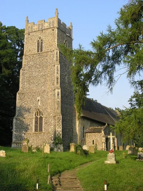
Church of St Andrew — church in Westhall, Suffolk, England, UK.

Wikimedia Commons contributors — see linked file page for photographer and licence licence

Plan your visit
- Typical visit
- 30 min–1 h
- Nearest railway station
- Brampton · 3.2 km
- Free entry
About
Church of St Andrew is a historic church in the United Kingdom. Records date its origin to 1201. Heritage designation: Grade I listed building. Affiliated with Anglicanism. Wikidata describes it as: "church in Westhall, Suffolk, England, UK". Coordinates: 52.3683°, 1.5582°.
Photo gallery
Official information
The Church of St Andrew is part of the Hundred River and Wainford Benefice, which includes nine parishes in the Suffolk countryside. Visitors are welcome to join the congregation for worship and fellowship.
Protected designations
- Area of Outstanding Natural Beauty: Suffolk Coast & Heaths
Designations sourced from Natural England open data under OGL v3.
From the Wikipedia article
St Andrew's Church is located in the village of Westhall near Halesworth. It is an active Anglican parish church in the deanery of Waveney and Blyth, part of the archdeaconry of Suffolk, and the Diocese of St Edmundsbury and Ipswich.
Excerpt from Wikipedia under CC BY-SA 4.0. See the source article linked in Sources below.
Background
Architecture
The church is of flint construction and comprises a nave, south aisle chancel and tower. The unusual layout is due to the church having been extended from the original Norman building and the original church becoming what is now the church's south aisle. The eastern entrance dates from around 1100 and stonework including depictions of humans and animals including bird head grotesques and human-animal hybrids as well as unfinished faces are still visible.
Sourced from Wikipedia under CC BY-SA 4.0.
- Coordinates
- 52.3683, 1.5582
- County
- Suffolk
- District
- East Suffolk
- Parish
- Westhall
- Postcode
- IP19 8NU
- Parliamentary constituency
- Waveney Valley
- Established
- 1201
- Nearest railway station
- Brampton — 3.2 km
- Official site
- www.hundredriverandwainfordbenefice.org.uk
Sources
- wikidata: Q17527446 (CC0)
- wikipedia: St Andrew's Church, Westhall (CC BY-SA 4.0)
- commons: Westhall - Church of St Andrew.jpg (CC BY-SA 4.0)
Other places nearby

Westhall Old School
Natural landmarks · 1.1 km
Church of St Peter
Historic churches · 1.6 km

Westhall Village Sign
Public art & sculpture · 1.9 km

Sotherton
Villages · 2.0 km
_St_Margaret's_Church_-_geograph.org.uk_-_68600.jpg?width=1200)
Stoven
Towns & cities · 2.1 km

Belle Grove
Hotels · 2.2 km

Cherry Tree Public House
Historic pubs · 2.8 km

Halesworth Airfield Museum
Museums · 2.8 km

Craven's Manor
Manor houses · 2.8 km

5th Emergency Rescue Squadron Memorial
Memorials & monuments · 2.8 km
56th Fighter Group (Zemke's Wolfpack) Memorial
Memorials & monuments · 2.8 km
Halesworth Airfield Memorials
Memorials & monuments · 2.8 km
Nearby
📷 5Natural landmarks · East of England
Westhall Old School
Westhall Old School — a school heritage in england-east, United Kingdom.
📷 3Historic churches · East of England
Church of St Peter
Church of St Peter — church in Brampton, Suffolk, England, UK.
📷 3Public art & sculpture · East of England
Westhall Village Sign
Westhall Village Sign — a public art in East of England, United Kingdom.
📷 5📷 3📷 5Where to eat & stay near Church of St Andrew
Places to stay
📷 5 📷 5
📷 5 📷 5
📷 5Campsites · East of England
Halesworth Holiday Park
Halesworth Holiday Park — a campsite in england east.
 📷 5
📷 5 📷 3
📷 3 📷 5
📷 5Places to eat & drink
📷 5Historic pubs · East of England
Cherry Tree Public House
Cherry Tree Public House in England East, United Kingdom.
 📷 5
📷 5 📷 5
📷 5Historic pubs · East of England
Crown And Anchor Public House
Crown And Anchor Public House in England East, United Kingdom.
 📷 5
📷 5 📷 5
📷 5Historic pubs · East of England
Huntingfield Arms
Huntingfield Arms in England East, United Kingdom.
 📷 7
📷 7Other places from this era
 📷 5
📷 5Historic churches · London
All Hallows Staining
All Hallows Staining — church in City of London, UK.
 📷 5
📷 5Historic churches · London
All Hallows' Church, Tottenham
All Hallows' Church, Tottenham — church in Tottenham, London.
 📷 5
📷 5Historic churches · London
All Saints Church, Kingston upon Thames
All Saints Church, Kingston upon Thames — church in Kingston upon Thames, London.
 📷 5
📷 5Historic churches · London
All Saints' Church, Edmonton
All Saints' Church, Edmonton — church in Edmonton, London.
More places in this region
 📷 5
📷 5Historic churches · East of England
All Saints Church
All Saints Church — church on Jesus Lane in central Cambridge, England.
 📷 5
📷 5Historic churches · East of England
All Saints Church, Conington
All Saints Church, Conington — church in Conington, Huntingdonshire, Cambridgeshire, England, UK.
 📷 5
📷 5Historic churches · East of England
All Saints Church, Vange
All Saints Church, Vange — church in Basildon, Essex, England, UK.
 📷 5
📷 5Historic churches · East of England
All Saints Parish Church, Kirtling
All Saints Parish Church, Kirtling — church in East Cambridgeshire, England, UK.
Frequently asked questions
- Where is Church of St Andrew?
- Church of St Andrew is in Suffolk, East of England, United Kingdom (postcode IP19 8NU), in the parish of Westhall.
- What is Church of St Andrew?
- Church of St Andrew — church in Westhall, Suffolk, England, UK.
- How do I get to Church of St Andrew?
- The nearest railway station is Brampton, about 3.2 km away. The nearest town is Stoven. Drivers can use postcode IP19 8NU.
- When was Church of St Andrew built?
- Built or established in 1201.
- Is Church of St Andrew a listed building?
- Church of St Andrew is officially recognised as Grade I listed building listed.
- Is Church of St Andrew a protected site?
- Yes — Church of St Andrew is part of the Suffolk Coast & Heaths National Landscape (AONB).
- Is Church of St Andrew free to visit?
- Yes, Church of St Andrew is free to enter.
- How do I get to Church of St Andrew?
- The nearest railway station is Brampton, about 3.2 km away. Drivers can navigate to postcode IP19 8NU.