
Historic bridges · East Midlands
Chesterfield Canal Bridge 37 And Turnerwood Lock With Associated Overflow Structure At Cinder Hill
In or near Woodsetts.
Chesterfield Canal Bridge 37 And Turnerwood Lock With Associated Overflow Structure At Cinder Hill — Grade II listed building-listed bridge in england-east-midlands, United Kingdom.

Alan Heardman — CC BY-SA 2.0 via Wikimedia Commons licence

Plan your visit
- Typical visit
- 15 min–30 min
- Nearest railway station
- Shireoaks · 0.5 km
- Free entry
- Dog-friendly
Getting there & planning your visit
To visit Chesterfield Canal Bridge 37 and Turnerwood Lock, you can reach the nearest railway station, Shireoaks, which is 0.5 km away. Entry is free, and the location is accessible. The postcode for sat-nav is S81 8NR.
About
Chesterfield Canal Bridge 37 And Turnerwood Lock With Associated Overflow Structure At Cinder Hill is a Grade II listed building-listed bridge in england-east-midlands, United Kingdom, registered on the National Heritage List for England (NHLE entry 1314642). Listed status protects buildings and structures of special architectural or historic interest. See the linked Wikipedia article for further details.
Photo gallery
Heritage listing
Details NORTH AND SOUTH ANSTON CHESTERFIELD CANAL SK58SW 5/62 Bridge 37 and Turnerwood Lock with associated overflow structure at Cinder Hill II Bridge with associated lock and overflow structure. Late C18, bridge probably early C19. For the Chesterfield Canal Company. Single-span bridge with integral lock to west and overflow channel emerging at sluice near south-east corner of bridge. Bridge: round-nosed brick voussoirs to basket arch, abutment walls curve out to terminate at rounded projecting end piers, parapet with stone copings curves down to each side. Brick-arched overflow tunnel emerges near south- east corner and empties via lined sluice into canal. Lock: stone entry and exit walls; stone course near low water level with brickwork above; ashlar lock- gate recesses with hollow-quoined heel-post housings. Important element of the Chesterfield Canal surveyed by James Brindley and built between 1771 and 1777 and remaining in water through the parishes of Thorpe Salvin and North and South Anston. Forms eastern end of the Turnerwood Flight of locks (q.v.). Listing NGR: SK5494681270 Legacy The contents of this record have been generated from a legacy data system. Legacy System number: 335811 Legacy System: LBS
From the Historic England List Entry under OGL v3.
Place summary
Chesterfield Canal Bridge 37 and Turnerwood Lock, located at Cinder Hill in the East Midlands, is a Grade II listed structure. This site features an associated overflow structure and serves as an important part of the canal's historical infrastructure. It is situated within the parish of North and South Anston.
AI-generated from the structured facts on this page (operator, designation, listing, era). Not a substitute for visiting.
- Coordinates
- 53.3255, -1.1765
- District
- Rotherham
- Parish
- North and South Anston
- Postcode
- S81 8NR
- Parliamentary constituency
- Rother Valley
- Nearest railway station
- Shireoaks — 0.5 km
Sources
- wikidata: Q26601080 (CC0)
Other places nearby

Shireoaks War Memorial
Memorials & monuments · 0.5 km

Shireoaks
Villages · 0.7 km
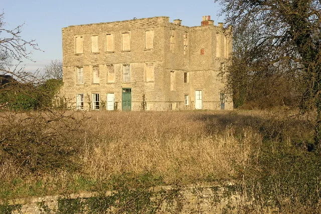
Shireoaks Hall
Historic houses · 0.7 km

Woodlands View Point
Viewpoints · 1.4 km

Chesterfield Canal Bridge 35 And Top Treble Lock (To West Of Low Spring Wood)
Historic bridges · 1.6 km

Chesterfield Canal Pudding Dike Bridge
Historic bridges · 2.1 km

Thorpe Salvin
Villages · 2.7 km

Chesterfield Canal Devil's Hole Bridge
Historic bridges · 2.8 km

Thorpe Salvin Old Hall
Historic houses · 2.8 km

Woodsetts
Towns & cities · 2.8 km

Thorpe Salvin Village Sign
Public art & sculpture · 2.8 km

Dead Man's Cave, Anston
Caves · 3.1 km
Nearby
📷 3Memorials & monuments · East Midlands
Shireoaks War Memorial
Shireoaks War Memorial — Grade II listed building-listed memorial in england-east-midlands, United Kingdom.
📷 5📷 3Historic houses · East Midlands
Shireoaks Hall
Shireoaks Hall — house in Shireoaks, Nottinghamshire, England, UK.
📷 3Viewpoints · East Midlands
Woodlands View Point
Woodlands View Point is a viewpoint in the United Kingdom.
📷 3Historic bridges · East Midlands
Chesterfield Canal Bridge 35 And Top Treble Lock (To West Of Low Spring Wood)
Chesterfield Canal Bridge 35 And Top Treble Lock (To West Of Low Spring Wood) — Grade II listed building-listed bridge in england-east-midlands, United Kingdom.
📷 3Historic bridges · East Midlands
Chesterfield Canal Pudding Dike Bridge
Chesterfield Canal Pudding Dike Bridge — Grade II listed building-listed bridge in england-east-midlands, United Kingdom.
Where to eat & stay near Chesterfield Canal Bridge 37 And Turnerwood Lock With Associated Overflow Structure At Cinder Hill
Places to stay
 📷 5
📷 5Campsites · East Midlands
Clumber Park Lodges
Clumber Park Lodges — a campsite in england east midlands.
 📷 5
📷 5Caravan parks · East Midlands
Clumber Park Caravan and Motorhome Club
Clumber Park Caravan and Motorhome Club — a caravan park in england east midlands.
 📷 5
📷 5Hotels · East Midlands
Hellaby Hall Hotel
Hellaby Hall Hotel — a hotel in england east midlands.
 📷 5
📷 5Caravan parks · East Midlands
Plumtree Caravan Park
Plumtree Caravan Park — a caravan park in england east midlands.
 📷 5
📷 5Campsites · East Midlands
Pilgrim Fathers Camping Site
Pilgrim Fathers Camping Site — a campsite in england east midlands.
 📷 5
📷 5Caravan parks · East Midlands
Caravan Club Site - Poolsbrook
Caravan Club Site - Poolsbrook — a caravan park in england east midlands.
Places to eat & drink
 📷 5
📷 5 📷 5
📷 5Historic pubs · East Midlands
The Red Hart Hotel
The Red Hart Hotel in England Yorkshire, United Kingdom.
 📷 5
📷 5Historic pubs · East Midlands
The Greendale Oak Inn
The Greendale Oak Inn in England East Midlands, United Kingdom.
 📷 5
📷 5 📷 3
📷 3Restaurants · East Midlands
The Old Vicarage, Derbyshire
The Old Vicarage is a restaurant located in Ridgeway, near Sheffield. The restaurant held one star in the Michelin Guide from 1998 to 2015. The head chef is TV chef Tessa Bramley.
 📷 5
📷 5Historic pubs · East Midlands
Newcastle Arms Public House
Newcastle Arms Public House in England Yorkshire, United Kingdom.
More bridges in this region
 📷 5
📷 5Historic bridges · East Midlands
Mill Race Bridge To Market Deeping Mill
Mill Race Bridge To Market Deeping Mill — Grade II listed building-listed bridge in england-london, United Kingdom.
 📷 5
📷 5Historic bridges · East Midlands
Bridge Over West Glen River
Bridge Over West Glen River — Grade II listed building-listed bridge in england-london, United Kingdom.
 📷 5
📷 5Historic bridges · East Midlands
Bridge And Sluices
Bridge And Sluices — Grade II listed building-listed bridge in england-london, United Kingdom.
 📷 5
📷 5Historic bridges · East Midlands
Bridge Over River Gwash
Bridge Over River Gwash — Grade II listed building-listed bridge in england-london, United Kingdom.
Frequently asked questions
- Where is Chesterfield Canal Bridge 37 And Turnerwood Lock With Associated Overflow Structure At Cinder Hill?
- Chesterfield Canal Bridge 37 And Turnerwood Lock With Associated Overflow Structure At Cinder Hill is in the East Midlands, United Kingdom (postcode S81 8NR), in the parish of North and South Anston.
- What is Chesterfield Canal Bridge 37 And Turnerwood Lock With Associated Overflow Structure At Cinder Hill?
- Chesterfield Canal Bridge 37 And Turnerwood Lock With Associated Overflow Structure At Cinder Hill — Grade II listed building-listed bridge in england-east-midlands, United Kingdom.
- How do I get to Chesterfield Canal Bridge 37 And Turnerwood Lock With Associated Overflow Structure At Cinder Hill?
- The nearest railway station is Shireoaks, about 0.5 km away. The nearest town is Woodsetts. Drivers can use postcode S81 8NR.
- Is Chesterfield Canal Bridge 37 And Turnerwood Lock With Associated Overflow Structure At Cinder Hill a listed building?
- Chesterfield Canal Bridge 37 And Turnerwood Lock With Associated Overflow Structure At Cinder Hill is officially recognised as Grade II listed building listed.
- Is Chesterfield Canal Bridge 37 And Turnerwood Lock With Associated Overflow Structure At Cinder Hill free to visit?
- Yes, Chesterfield Canal Bridge 37 And Turnerwood Lock With Associated Overflow Structure At Cinder Hill is free to enter.
- How do I get to Chesterfield Canal Bridge 37 And Turnerwood Lock With Associated Overflow Structure At Cinder Hill?
- The nearest railway station is Shireoaks, about 0.5 km away. Drivers can navigate to postcode S81 8NR.