Museums · London
Cheshunt
In or near Goffs Oak.
Cheshunt ( CHEZ-ənt) is a town in the Borough of Broxbourne, in Hertfordshire, England. It lies within the London commuter belt approximately 13 miles (21 km) north of Central London, on the River Lea

Oast House Archive — CC BY-SA 2.0 via Wikimedia Commons licence
Plan your visit
- Typical visit
- 1.5 h–3 h
- Best time of year
- Year-round
- Nearest railway station
- Cheshunt · 0.8 km
- Family-friendly
- Limited wheelchair access
Getting there & planning your visit
To visit Cheshunt museum, you can reach it via Cheshunt railway station, which is 0.8 km away. The postcode for the museum is EN8 8LQ. Please note that wheelchair accessibility is limited.
About
Cheshunt ( CHEZ-ənt) is a town in the Borough of Broxbourne, in Hertfordshire, England. It lies within the London commuter belt approximately 13 miles (21 km) north of Central London, on the River Lea and Lee Navigation, bordering the Lee Valley Park. At the 2021 census, the Cheshunt built-up area had a population of 43,680. Cheshunt was recorded as Cestrehunt in the Domesday Book of 1086. The original centre of Cheshunt was around St Mary's Church, near the course of the Roman road of Ermine Street. The main centre subsequently shifted eastwards onto the High Street and Turners Hill, which together form a main road running roughly parallel to the River Lea. Cheshunt was an ancient parish; as well as Cheshunt itself the parish also covered Waltham Cross, Turnford, Goffs Oak, and surrounding rural areas. The parish included a number of large country houses and their estates, notably including Cheshunt Great House, Cheshunt Park, and Theobalds. The civil parish of Cheshunt was abolished in 1974 on the creation of the borough of Broxbourne. In the 20th century, the town was known for glasshouse horticulture and rose cultivation. Cheshunt today is a commuter town with regular services via Cheshunt railway station on the West Anglia Main Line and London Overground, and is accessible by road via the A10 and M25 motorway.
Photo gallery
See it from the streetimagery from 2020
Imagery © Mapillary contributors, CC BY-SA 4.0
From the Wikipedia article
Cheshunt ( CHEZ-ənt) is a town in the Borough of Broxbourne, in Hertfordshire, England. It lies within the London commuter belt approximately 13 miles (21 km) north of Central London, on the River Lea and Lee Navigation, bordering the Lee Valley Park. At the 2021 census, the Cheshunt built-up area had a population of 43,680. Cheshunt was recorded as Cestrehunt in the Domesday Book of 1086. The original centre of Cheshunt was around St Mary's Church, near the course of the Roman road of Ermine Street. The main centre subsequently shifted eastwards onto the High Street and Turners Hill, which together form a main road running roughly parallel to the River Lea. Cheshunt was an ancient parish; as well as Cheshunt itself the parish also covered Waltham Cross, Turnford, Goffs Oak, and surrounding rural areas. The parish included a number of large country houses and their estates, notably including Cheshunt Great House, Cheshunt Park, and Theobalds. The civil parish of Cheshunt was abolished in 1974 on the creation of the borough of Broxbourne. In the 20th century, the town was known for glasshouse horticulture and rose cultivation. Cheshunt today is a commuter town with regular services via Cheshunt railway station on the West Anglia Main Line and London Overground, and is accessible by road via the A10 and M25 motorway.
Excerpt from Wikipedia under CC BY-SA 4.0. See the source article linked in Sources below.
- Coordinates
- 51.7022, -0.0347
- County
- Hertfordshire
- District
- Broxbourne
- Parish
- Broxbourne, unparished area
- Postcode
- EN8 8LQ
- Parliamentary constituency
- Broxbourne
- Nearest railway station
- Cheshunt — 0.8 km
Sources
- wikipedia: Cheshunt (CC BY-SA 4.0)
Other places nearby

Goffs-Churchgate Academy
Natural landmarks · 0.7 km

YHA Lee Valley Village
Hostels · 0.9 km

The Henge
Public art & sculpture · 0.9 km

Fire
Public art & sculpture · 1.0 km
Water
Public art & sculpture · 1.0 km

The Giant's Chair
Public art & sculpture · 1.0 km

St Mary the Virgin, Cheshunt
Historic churches · 1.0 km

Obelisk To Ashford Family In Churchyard Of Parish Church Of St Mary On North Side Of Nave
Forts · 1.0 km

Stag Beatles
Public art & sculpture · 1.0 km

Bowyer's Water
Lakes · 1.1 km

Cheshunt Lake
Lakes · 1.1 km

Site of Royal Palace
Palaces · 1.1 km
Nearby
📷 5Natural landmarks · London
Goffs-Churchgate Academy
Goffs-Churchgate Academy — a school heritage in england-london, United Kingdom.
📷 5📷 5Public art & sculpture · London
The Henge
The Henge — a public art in england-london, United Kingdom.
📷 5📷 5📷 5Public art & sculpture · London
The Giant's Chair
The Giant's Chair — a public art in england-london, United Kingdom.
Where to eat & stay near Cheshunt
Places to stay
📷 5 📷 5
📷 5Campsites · East of England
Lee Valley Almost Wild Campsite
Lee Valley Almost Wild Campsite — a campsite in england london.
 📷 5
📷 5Campsites · London
Lee Valley Campsite, Sewardstone
Lee Valley Campsite, Sewardstone — a campsite in england london.
 📷 5
📷 5Campsites · East of England
Danemead Scout Campsite
Danemead Scout Campsite — a campsite in england london.
 📷 5
📷 5 📷 5
📷 5Places to eat & drink
 📷 5
📷 5Historic pubs · London
The Queens Arms Public House
The Queens Arms Public House in England London, United Kingdom.
 📷 5
📷 5Historic pubs · London
The King And Tinker Public House
The King And Tinker Public House in England London, United Kingdom.
 📷 5
📷 5Historic pubs · East of England
The Woodman Public House
The Woodman Public House in England East, United Kingdom.
 📷 5
📷 5 📷 5
📷 5Historic pubs · East of England
The Golden Lion Inn
The Golden Lion Inn in England East, United Kingdom.
 📷 5
📷 5More museums in this region
 Flagship📷 10
Museums · London
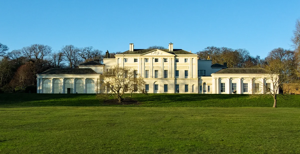
Kenwood House
Kenwood House — art museum and historic house in Hampstead, London.
 📷 5
📷 5Museums · London
Amora London
Amora London — European touring exhibition dedicated to love, relationships and sexual wellbeing.
 📷 5
📷 5Museums · London
Antique Breadboard Museum
Antique Breadboard Museum — small museum in Putney, London, England, UK.
 📷 5
📷 5Museums · London
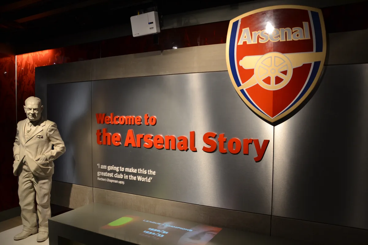
Arsenal Football Club Museum
Arsenal Football Club Museum — sports museum in London.
Frequently asked questions
- Where is Cheshunt?
- Cheshunt is in Hertfordshire, London, United Kingdom (postcode EN8 8LQ), in the parish of Broxbourne, unparished area.
- What is Cheshunt?
- Cheshunt ( CHEZ-ənt) is a town in the Borough of Broxbourne, in Hertfordshire, England. It lies within the London commuter belt approximately 13 miles (21 km) north of Central London, on the River Lea
- How do I get to Cheshunt?
- The nearest railway station is Cheshunt, about 0.8 km away. Drivers can use postcode EN8 8LQ.
- How do I get to Cheshunt?
- The nearest railway station is Cheshunt, about 0.8 km away. Drivers can navigate to postcode EN8 8LQ.