
Natural landmarks · Northern Ireland
Cavehill
Also known as: Binn Mhadagáin
In or near Belfast.
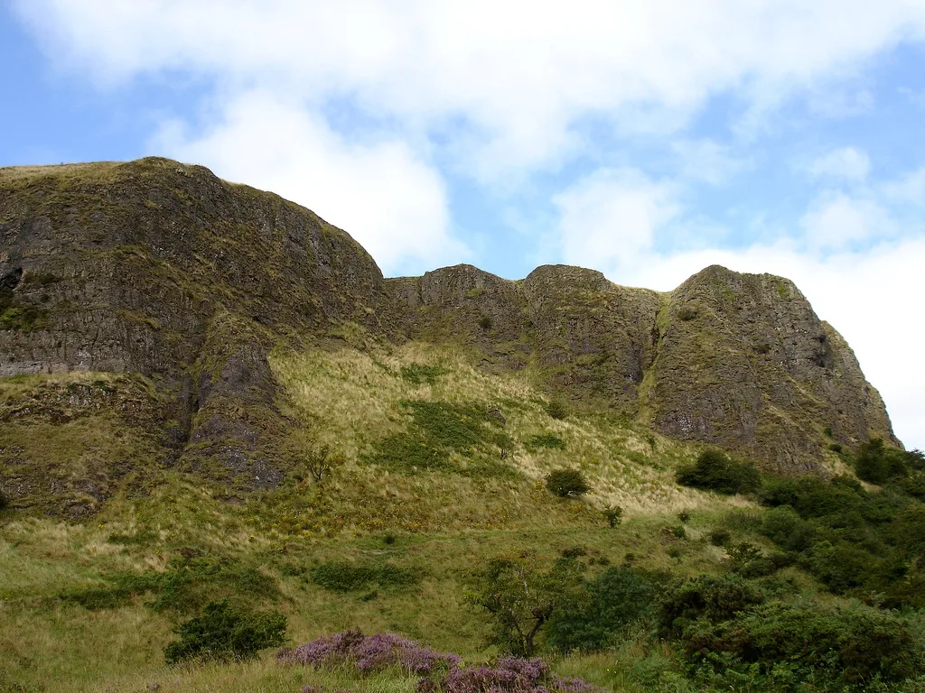
Cavehill — hill overlooking the city of Belfast in Northern Ireland.

Wikimedia Commons contributors — see linked file page for photographer and licence licence

Plan your visit
- Typical visit
- 1 h–2 h
- Nearest railway station
- Whiteabbey · 4.1 km
- Free entry
- Dog-friendly
Getting there & planning your visit
To visit Cavehill in Belfast, you can take the train to Whiteabbey station, which is approximately 4.1 km away. Entry to the site is free, and it is accessible to visitors. The postcode for navigation is BT15 5GR.
About
Cavehill is a named natural landmark in the United Kingdom. Constructed primarily of basalt. Wikidata describes it as: "hill overlooking the city of Belfast in Northern Ireland". Coordinates: 54.6470°, -5.9510°.
Photo gallery
From the Wikipedia article
Cave Hill — or Cavehill — is a rocky hill overlooking the city of Belfast, Northern Ireland, with a height of 368 metres (1,207 ft). It is marked by basalt cliffs and caves, and its distinguishing feature is 'Napoleon's Nose', a tall cliff fancifully said to resemble the profile of the famous emperor of that name. At its highest point are the remains of an ancient promontory fort called McArt's Fort. Cavehill was also historically called 'Ben Madigan' (from Irish: Beann Mhadagáin, "Madagán’s peak"), after a king of Ulster called Madagán. Cave Hill, which is within Cave Hill Country Park, forms part of the Belfast Hills and marks the southeastern edge of the Antrim Plateau. All of Belfast can be seen from its peak, as can the Isle of Man and Scotland on clear days. Like Arthur's Seat in Edinburgh, it lies just a few miles from the centre of a major city. Cave Hill is thought to be the inspiration for Jonathan Swift's Gulliver's Travels. Swift imagined that Cave Hill resembled the shape of a sleeping giant safeguarding the city.
Excerpt from Wikipedia under CC BY-SA 4.0. See the source article linked in Sources below.
Background
History
The name 'Cave Hill' appears to be a translation of the Irish . The hill was originally known in Irish as (meaning "Madagán's peak"), after a king of Ulaid (Ulster), Matudán mac Muiredaig, who died in 856 AD. It could also be named after a later king, Matudán mac Áeda (reigned 937–950). The later king's grandson, Eochaid mac Ardgail, was killed at the battle of Crew Hill in 1004, in which the men of Ulster were defeated by their old enemies, the Cenél nEógain. It is from him that McArt's Fort derived its name. The residential neighbourhood at the foot of Cave Hill's entrance is derivatively known as Ben Madigan, with street names to match, and is a wealthy semi-outer city, semi-suburban…
Description
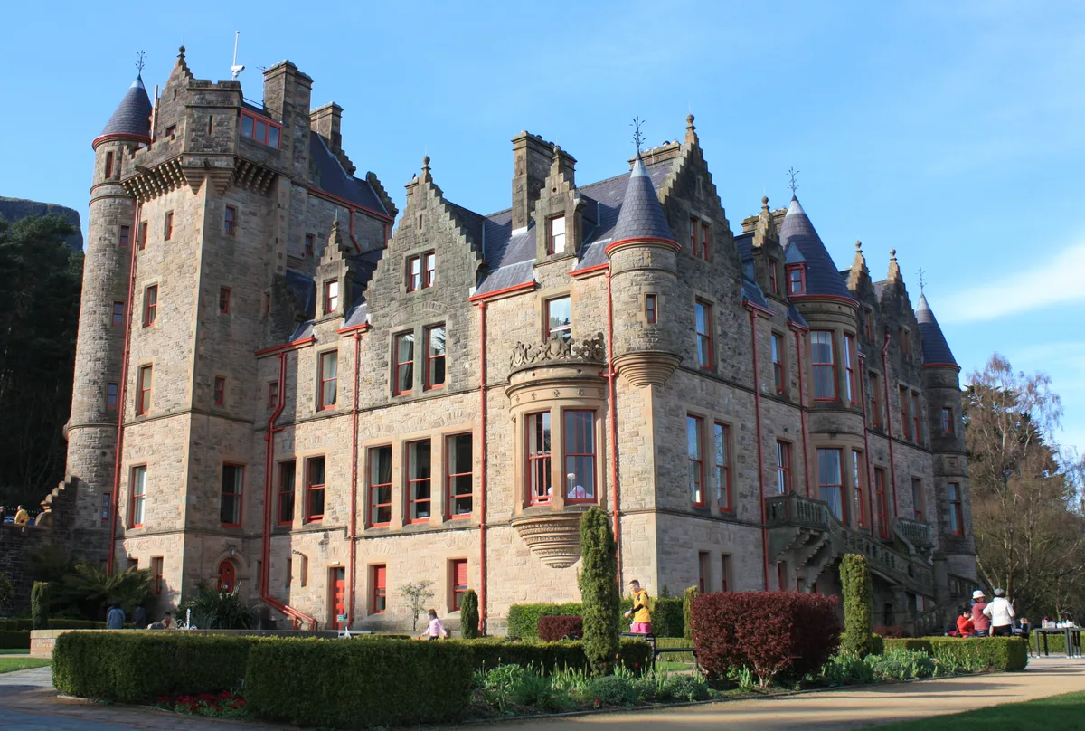
Cave Hill rises to 368 m above sea level. Most of its lower east side lies on the Belfast Castle estate, which has as its focal point the imposing 19th-century Scottish baronial castle. The castle was designed by the firm of Lanyon, Lynn and Lanyon and was constructed for The 3rd Marquess of Donegall in the late 1860s and early 1870s in the Deer Park. The slopes of Cave Hill were originally used as farmland but, from the 1880s, a major planting exercise was undertaken, producing the now familiar deciduous and coniferous woodland landscape. Belfast Castle estate was given to the City of Belfast by The 9th Earl of Shaftesbury in 1934.
Visiting
Cave Hill Country Park, Belfast Zoo and Belfast Castle are visited by both locals and tourists. In the 18th century, the people of Belfast visited the area on Easter Monday for the Cave Hill fete, near a spring known as the 'Volunteers' Well'. The summit has views southwards over Belfast City and Lough towards the Mourne Mountains, Scrabo Tower and Slieve Croob.
Sourced from Wikipedia under CC BY-SA 4.0.
- Coordinates
- 54.6470, -5.9510
- District
- Belfast
- Postcode
- BT15 5GR
- Parliamentary constituency
- Belfast North
- Nearest railway station
- Whiteabbey — 4.1 km
Sources
- wikidata: Q56693 (CC0)
- wikipedia: Cavehill (CC BY-SA 4.0)
- commons: Cavehill, Belfast.jpg (CC BY-SA 4.0)
Other places nearby

Cave Hill
Mountains & hills · 0.1 km
Cavehill
Mountains & hills · 0.1 km

McArt's Fort
Vineyards · 0.2 km

McArt's Fort
Forts · 0.2 km

Cave Hill Cave
Caves · 0.4 km

Belfast Castle
Viewpoints · 0.7 km
Belfast Castle
Castles · 0.7 km

Malayan Sun Bear
Natural landmarks · 0.8 km

Belfast North
Natural landmarks · 0.8 km

The Millennium Maze
Natural landmarks · 0.8 km
B-17 WWII Crash Memorial
Memorials & monuments · 0.8 km
Cheetah
Natural landmarks · 0.9 km
Nearby
📷 5📷 3📷 5Vineyards · Northern Ireland
McArt's Fort
McArt's Fort — a UK vineyard in northern ireland, producing English or Welsh wine from cool-climate grape varieties.
📷 3📷 5📷 4Viewpoints · Northern Ireland
Belfast Castle
Belfast Castle is a viewpoint in the United Kingdom.
Where to eat & stay near Cavehill
Places to stay
 📷 5
📷 5Hostels · Northern Ireland
Somerton Road Children's Home
Somerton Road Children's Home — a hostel in northern ireland.
📷 5Hostels · Northern Ireland
Willow Lodge Residential Short Breaks Services
Willow Lodge Residential Short Breaks Services — a hostel in northern ireland.
 📷 5
📷 5Caravan parks · Northern Ireland
Jordanstown Loughshore Caravan Park
Jordanstown Loughshore Caravan Park — a caravan park in northern ireland.
 📷 7
📷 7Hotels · Northern Ireland
DoubleTree by Hilton Belfast City Ten Square
DoubleTree by Hilton Belfast City Ten Square — a hotel in northern ireland. Brand: DoubleTree.
.JPG?width=1200) 📷 5
📷 5Places to eat & drink
 📷 5
📷 5 📷 7
📷 7Historic pubs · Northern Ireland
Kelly's Cellars
Kelly's Cellars in Northern Ireland, United Kingdom.
 📷 5
📷 5Historic pubs · Northern Ireland
Kitchen Bar
Kitchen Bar in Northern Ireland, United Kingdom.
 📷 7
📷 7Historic pubs · Northern Ireland
Crown Liquor Saloon
Crown Liquor Saloon in Northern Ireland, United Kingdom.
 📷 3
📷 3Historic pubs · Northern Ireland
Red Lion Pub bombing
Red Lion Pub bombing in Northern Ireland, United Kingdom.
 📷 5
📷 5Historic pubs · Northern Ireland
The Botanic Inn
The Botanic Inn in Northern Ireland, United Kingdom.
More natural landmarks in this region
 Flagship📷 4
Natural landmarks · Northern Ireland
Lough Erne
Lough Erne — lake in County Fermanagh, Northern Ireland, UK.
 Flagship📷 4
Natural landmarks · Northern Ireland
Lough Neagh
Lough Neagh — large lake in Northern Ireland.
 📷 3
📷 3Natural landmarks · Northern Ireland
Ballysaggart Lough
Ballysaggart Lough — lake in the United Kingdom.
 📷 5
📷 5Natural landmarks · Northern Ireland
Belmore Mountain
Belmore Mountain — mountain in the United Kingdom.
Frequently asked questions
- Where is Cavehill?
- Cavehill is in Northern Ireland, United Kingdom (postcode BT15 5GR).
- What is Cavehill?
- Cavehill — hill overlooking the city of Belfast in Northern Ireland.
- How do I get to Cavehill?
- The nearest railway station is Whiteabbey, about 4.1 km away. The nearest town is Belfast. Drivers can use postcode BT15 5GR.
- Is Cavehill free to visit?
- Yes, Cavehill is free to enter.
- How do I get to Cavehill?
- The nearest railway station is Whiteabbey, about 4.1 km away. Drivers can navigate to postcode BT15 5GR.