Mountains & hills · Mid Wales
Carn Ingli
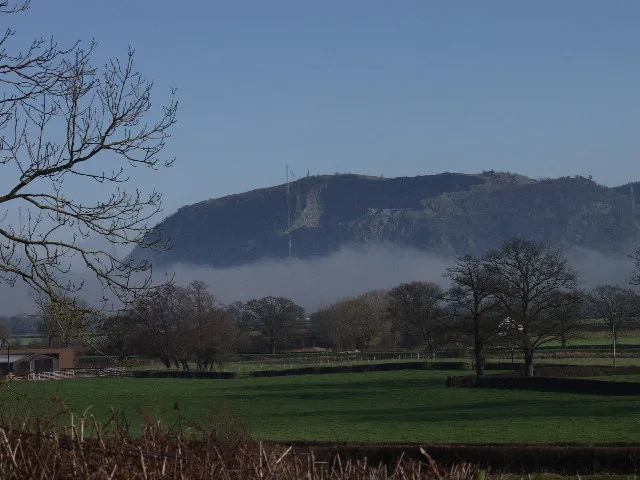
Carn Ingli — Named summit at 338 m.

Wikimedia Commons contributors — see linked file page for photographer and licence licence
Plan your visit
- Typical visit
- 3 h–8 h
- Best time of year
- Late spring – early autumn (May–Oct)
- Free entry
- Dog-friendly
About
Carn Ingli is a named summit in the United Kingdom. Wikidata describes it as: "Named summit at 338 m.". Coordinates: 51.9996°, -4.8240°.
Photo gallery
Heritage listing
http://cadwpublic-api.azurewebsites.net/reports/listedbuilding/FullReport?lang=en&id=23228
From Cadw under OGL v3.
From the Wikipedia article
Mynydd Carningli is a mountain in the Preseli Hills near the town of Newport, Pembrokeshire, Wales. It has both prehistoric and historic remains.
Excerpt from Wikipedia under CC BY-SA 4.0. See the source article linked in Sources below.
- Coordinates
- 51.9996, -4.8240
- District
- Pembrokeshire
- Parish
- Newport
- Postcode
- SA42 0QL
- Parliamentary constituency
- Ceredigion Preseli
Sources
- osm: n294491611 (ODbL)
- wikipedia: Mynydd Carningli (CC BY-SA 4.0)
- commons: Mynydd Carningli - geograph.org.uk - 27994.jpg (CC BY-SA 4.0)
Other places nearby

Mynydd Carningli
Mountains & hills · 0.0 km

Carningli Hillfort Inner Enclosure
Hill forts · 0.0 km
Carn Ingli Camp
Vineyards · 0.1 km

Neolithic Burial Chamber
Archaeological sites · 0.1 km

Carningli Hillfort Middle Enclosure
Hill forts · 0.1 km

Carningli Hillfort
Vineyards · 0.1 km

Carningli Hillfort Upper Platform
Hill forts · 0.1 km
Carningli Hillfort Outer Enclosure
Hill forts · 0.1 km

Carningli Hillfort Lower Platform
Hill forts · 0.2 km
Carningli South Settlement
Archaeological sites · 0.2 km

Rng Cairn
Burial mounds & barrows · 0.3 km

Carn Ingli Barrow Cemetery
Burial mounds & barrows · 0.6 km
Nearby
📷 5📷 3Hill forts · Mid Wales
Carningli Hillfort Inner Enclosure
Carningli Hillfort Inner Enclosure — a hill fort in wales-south, United Kingdom.
📷 5Vineyards · Mid Wales
Carn Ingli Camp
Carn Ingli Camp — a UK vineyard in wales south, producing English or Welsh wine from cool-climate grape varieties.
📷 3Archaeological sites · Mid Wales
Neolithic Burial Chamber
Neolithic Burial Chamber — a archaeological in wales-south, United Kingdom.
📷 3Hill forts · Mid Wales
Carningli Hillfort Middle Enclosure
Carningli Hillfort Middle Enclosure — a hill fort in wales-south, United Kingdom.
📷 5Vineyards · Mid Wales
Carningli Hillfort
Carningli Hillfort — a UK vineyard in wales mid, producing English or Welsh wine from cool-climate grape varieties.
Where to eat & stay near Carn Ingli
Places to stay
 📷 7
📷 7 📷 5
📷 5 📷 5
📷 5Caravan parks · Mid Wales
Newport Bay Caravan Parklands
Newport Bay Caravan Parklands — a caravan park in wales mid.
 📷 5
📷 5 📷 5
📷 5Campsites · Mid Wales
Morawelon Camping and Caravanning
Morawelon Camping and Caravanning — a campsite in wales mid.
 📷 5
📷 5Caravan parks · Mid Wales
Llwyngwair Manor Caravan Park & Hotel
Llwyngwair Manor Caravan Park & Hotel — a caravan park in wales mid.
Places to eat & drink
 📷 4
📷 4Historic pubs · Mid Wales
Dyffryn Arms
Dyffryn Arms — Historic pub — listed building or notable heritage status.
 📷 4
📷 4Historic pubs · Mid Wales
Crymmych Arms railway station
Crymmych Arms railway station in Wales Mid, United Kingdom.
 📷 5
📷 5Restaurants · Mid Wales
Fusion Bar and Restaurant
Fusion Bar and Restaurant — a restaurant in wales mid.
 📷 5
📷 5Historic pubs · Mid Wales
The Grosvenor
The Grosvenor — Historic pub — listed building or notable heritage status.
 📷 4
📷 4Historic pubs · Mid Wales
Cardiff Arms
Cardiff Arms — Historic pub — listed building or notable heritage status.
 📷 3
📷 3Historic pubs · Mid Wales
Bar 45
Bar 45 — Historic pub — listed building or notable heritage status.
More mountains in this region
 📷 3
📷 3 📷 3
📷 3 📷 3
📷 3 📷 3
📷 3Frequently asked questions
- Where is Carn Ingli?
- Carn Ingli is in South Wales, United Kingdom (postcode SA42 0QL), in the parish of Newport.
- What is Carn Ingli?
- Carn Ingli — Named summit at 338 m.
- How do I get to Carn Ingli?
- Drivers can use postcode SA42 0QL.
- Is Carn Ingli a listed building?
- Carn Ingli is officially recognised as II listed.
- Is Carn Ingli free to visit?
- Yes, Carn Ingli is free to enter.
- How do I get to Carn Ingli?
- Drivers can navigate to postcode SA42 0QL. It sits within the Ceredigion Preseli parliamentary constituency.