
Mountains & hills · Yorkshire & the Humber
Buckden Pike
Also known as: Ramsden Pike
In or near Hawkswick.
Buckden Pike — Named summit at 701.6 m.

Wikimedia Commons contributors — see linked file page for photographer and licence licence

Plan your visit
- Typical visit
- 3 h–8 h
- Best time of year
- Late spring – early autumn (May–Oct)
- Free entry
- Dog-friendly
About
Buckden Pike is a named summit in the United Kingdom. Also known as: Ramsden Pike. Wikidata describes it as: "Named summit at 701.6 m.". Coordinates: 54.2048°, -2.0619°.
Photo gallery
Protected designations
- Site of Special Scientific Interest: Upper Wharfedale SSSI
Designations sourced from Natural England open data under OGL v3.
From the Wikipedia article
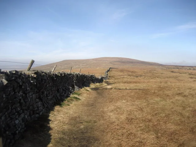
Buckden Pike is a fell at the head of Wharfedale, a valley in the Yorkshire Dales, that stands above the village of Buckden, England. At 702 metres (2,303 ft), it narrowly misses out on being the highest peak in the area, the title instead going to nearby Great Whernside (704 metres). The summit is marked by a trig point.
Excerpt from Wikipedia under CC BY-SA 4.0. See the source article linked in Sources below.
Background
Description
There are fine views from the summit. The most extensive are to the East and West. To the East is the ridge running from Little Whernside to the summit of Wharfedale's highest peak, Great Whernside. To the West are views into the heart of the Yorkshire Dales, including mountains such as The Yorkshire Three Peaks, as well as closer peaks such as Firth Fell and Yockenthwaite Moor. To be found close to the summit is a large wooden pole, standing vertically; it has a number of large holes focused on different views - this used to be labelled with information cards but is no longer.
Sourced from Wikipedia under CC BY-SA 4.0.
- Coordinates
- 54.2048, -2.0619
- Address
- Yorkshire Dales, England
Sources
- osm: n410142569 (ODbL)
- wikipedia: Buckden Pike (CC BY-SA 4.0)
- commons: Buckden Pike.jpg (CC BY-SA 4.0)
Other places nearby
Buckden Pike
Natural landmarks · 0.2 km

Buckden Pike Memorial Cross
Memorials & monuments · 0.9 km

Groove End Cave
Caves · 1.4 km

sink holes or old mining?
Archaeological sites · 1.9 km

old mining/sink holes?
Archaeological sites · 2.1 km

Buckden Bridge
Historic bridges · 2.5 km

Buckden Camping & Pods
Campsites · 2.6 km

sink holes or old mine shafts ?
Archaeological sites · 2.8 km

old mining ?
Archaeological sites · 3.1 km

sink holes / old mining ?
Archaeological sites · 3.1 km

Starbotton Peat Ground
Archaeological sites · 3.2 km

Cow Pasture Barn
Archaeological sites · 3.2 km
Nearby
📷 5Natural landmarks · Yorkshire & the Humber
Buckden Pike
Buckden Pike — mountain in United Kingdom.
📷 3Memorials & monuments · Yorkshire & the Humber
Buckden Pike Memorial Cross
Buckden Pike Memorial Cross is a memorial in the United Kingdom.
📷 3📷 3Archaeological sites · Yorkshire & the Humber
sink holes or old mining?
sink holes or old mining? — a archaeological in england-north-west, United Kingdom.
📷 3Archaeological sites · Yorkshire & the Humber
old mining/sink holes?
old mining/sink holes? — a archaeological in england-north-west, United Kingdom.
📷 3Historic bridges · Yorkshire & the Humber
Buckden Bridge
Buckden Bridge is a historic bridge in the United Kingdom.
Where to eat & stay near Buckden Pike
Places to stay
📷 5Campsites · Yorkshire & the Humber
Buckden Camping & Pods
Buckden Camping & Pods — a campsite in england north west.
 📷 7
📷 7B&Bs · Yorkshire & the Humber
The George Inn
The George Inn — a bed-and-breakfast in england north west.
 📷 5
📷 5Campsites · Yorkshire & the Humber
Wharfe Camp
Wharfe Camp — a campsite in england north west.
 📷 5
📷 5Hostels · Yorkshire & the Humber
Hag Dyke Scout Hostel
Hag Dyke Scout Hostel — a hostel in england north west.
 📷 5
📷 5Campsites · Yorkshire & the Humber
Kettlewell Camping Top Field
Kettlewell Camping Top Field — a campsite in england north west.
 📷 5
📷 5Caravan parks · Yorkshire & the Humber
Causeway Croft
Causeway Croft — a caravan park in england north west.
Places to eat & drink
 📷 5
📷 5Historic pubs · Yorkshire & the Humber
Foresters Arms Inn
Foresters Arms Inn in England Yorkshire, United Kingdom.
 📷 7
📷 7Historic pubs · Yorkshire & the Humber
Fox And Hounds Inn
Fox And Hounds Inn in England Yorkshire, United Kingdom.
 📷 5
📷 5Historic pubs · Yorkshire & the Humber
Grassington House Hotel
Grassington House Hotel in England Yorkshire, United Kingdom.
 📷 7
📷 7Cafés · Yorkshire & the Humber
The Castle Keep Tea Room
The Castle Keep Tea Room — a café in england yorkshire.
 📷 7
📷 7Cafés · Yorkshire & the Humber
Kim's Cafe & Bistro
Kim's Cafe & Bistro — a café in england yorkshire.
 📷 5
📷 5Restaurants · Yorkshire & the Humber
The Sandpiper Inn
The Sandpiper Inn — a restaurant in england yorkshire.
More mountains in this region
 📷 3
📷 3 📷 5
📷 5Mountains & hills · Yorkshire & the Humber
Whaley Moor
Whaley Moor — a hill or mountain in england west midlands.
 📷 5
📷 5Mountains & hills · Yorkshire & the Humber
Idle Hill
Idle Hill — a hill or mountain in england west midlands.
 📷 5
📷 5Mountains & hills · Yorkshire & the Humber
Hollingworthhall Moor
Hollingworthhall Moor — a hill or mountain in england west midlands.
Frequently asked questions
- Where is Buckden Pike?
- Buckden Pike is in North-West England, United Kingdom.
- What is Buckden Pike?
- Buckden Pike — Named summit at 701.6 m.
- How do I get to Buckden Pike?
- Its coordinates are 54.2048°, -2.0619°.
- Is Buckden Pike a protected site?
- Yes — Buckden Pike is part of the Upper Wharfedale SSSI Site of Special Scientific Interest.
- Is Buckden Pike free to visit?
- Yes, Buckden Pike is free to enter.