
Mountains & hills · Scottish Highlands
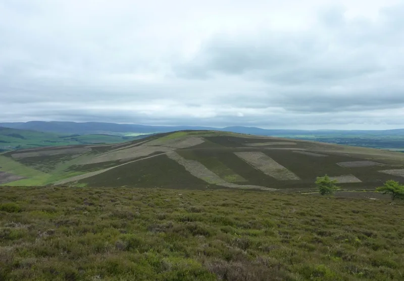
Brown Caterthun
In or near Edzell.
Brown Caterthun — Named summit at 286 m.

Wikimedia Commons contributors — see linked file page for photographer and licence licence

Plan your visit
- Typical visit
- 3 h–8 h
- Best time of year
- Late spring – early autumn (May–Oct)
- Nearest railway station
- Brechin · 8.1 km
- Free entry
- Dog-friendly
Getting there & planning your visit
To visit Brown Caterthun in the Scottish Highlands, the nearest railway station is Brechin, located 8.1 km away. Entry is free, and the postcode for sat-nav is DD9 7QP.
About
Brown Caterthun is a named summit in the United Kingdom. Wikidata describes it as: "Named summit at 286 m.". Coordinates: 56.7909°, -2.7291°.
Photo gallery
From the Wikipedia article
Caterthun, or the Caterthuns, is a ridge of hills near the city of Brechin in Angus, Scotland. The Caterthuns are notable for being the site of two Iron Age forts known as the White Caterthun and the Brown Caterthun which are designated as a scheduled monument. The White Caterthun, on the west, is dominated by an oval fort consisting of a massive dry-stone wall, with a well or cistern in the middle. The light-coloured stone wall gives the White Caterthun its name. The photo shows part of the dry-stone wall on the summit of the White Caterthun: The Brown Caterthun, on the east, consists of a series of earthen embankments (hence the name 'brown'). There is little evidence of settlement, agriculture or water supply here, so the purpose of the earthworks is uncertain. Brown may be from the British word for hill (bron / bryn). Both Caterthuns show several entrances to the summit that radiate outwards, like the spokes on a wheel. The significance of these entrances, if any, is unknown, but they may have aligned with geographical features that no longer exist, such as other settlements. From radio-carbon dating, the Brown Caterthun appears to have been built and modified over several centuries in the latter half of the first millennium BC. Parts of the White Caterthun may have been contemporary with the Brown Caterthun, but it is believed that the main stone wall was built by the Picts or their progenitors in the first few centuries AD.
Excerpt from Wikipedia under CC BY-SA 4.0. See the source article linked in Sources below.
- Coordinates
- 56.7909, -2.7291
- District
- Angus
- Postcode
- DD9 7QP
- Parliamentary constituency
- Angus and Perthshire Glens
- Nearest railway station
- Brechin — 8.1 km
Sources
- osm: n6539880058 (ODbL)
- wikipedia: Caterthun (CC BY-SA 4.0)
- commons: Brown Caterthun 20090616.jpg (CC BY-SA 4.0)
Other places nearby

Brown Caterthun
Vineyards · 0.0 km

Caterthun
Vineyards · 1.0 km
White Caterthun
Mountains & hills · 1.1 km

White Caterthun
Vineyards · 1.1 km

Lethnot Parish Church
Historic churches · 1.9 km
Lethnot War Memorial
Memorials & monuments · 1.9 km

Clochie Caravan Site
Caravan parks · 2.0 km

Balzeordie
Vineyards · 2.1 km

Navar Church
Archaeological sites · 2.6 km
Navar Parish Church
Historic churches · 2.6 km

Menmuir War Memorial
Memorials & monuments · 3.0 km

Birken Hill
Mountains & hills · 3.0 km
Nearby
📷 5Vineyards · Scottish Highlands
Brown Caterthun
Brown Caterthun — a UK vineyard in scotland highlands, producing English or Welsh wine from cool-climate grape varieties.
📷 5Vineyards · Scottish Highlands
Caterthun
Caterthun — a UK vineyard in scotland highlands, producing English or Welsh wine from cool-climate grape varieties.
📷 5📷 5Vineyards · Scottish Highlands
White Caterthun
White Caterthun — a UK vineyard in scotland highlands, producing English or Welsh wine from cool-climate grape varieties.
📷 5Historic churches · Scottish Highlands
Lethnot Parish Church
Lethnot Parish Church — category B listed building-listed church in scotland-highlands, United Kingdom.
📷 3Memorials & monuments · Scottish Highlands
Lethnot War Memorial
Lethnot War Memorial — a memorial in Scottish Highlands, United Kingdom.
Where to eat & stay near Brown Caterthun
Places to stay
📷 5Caravan parks · Scottish Highlands
Clochie Caravan Site
Clochie Caravan Site — a caravan park in scotland highlands.
 📷 5
📷 5Campsites · Scottish Highlands
Glenesk Caravan Park
Glenesk Caravan Park — a campsite in scotland highlands.
 📷 5
📷 5Caravan parks · Scottish Highlands
Dovecot Caravan Park
Dovecot Caravan Park — a caravan park in scotland highlands.
 📷 5
📷 5Caravan parks · Scottish Highlands
Tayock Park
Tayock Park — a caravan park in scotland highlands.
 📷 5
📷 5Caravan parks · Scottish Highlands
Foresterseat Caravan Park
Foresterseat Caravan Park — a caravan park in scotland highlands.
 📷 5
📷 5Hotels · Scottish Highlands
House of Mark
House of Mark — a hotel in scotland highlands.
Places to eat & drink
 📷 5
📷 5Historic pubs · Scottish Highlands
95 High Street, Montrose
95 High Street, Montrose in Scotland Highlands, United Kingdom.
 📷 5
📷 5Historic pubs · Scottish Highlands
23 Osnaburg Street, Forfar
23 Osnaburg Street, Forfar in Scotland Highlands, United Kingdom.
More mountains in this region
 📷 3
📷 3Mountains & hills · Scottish Highlands
A' Bhuidheanach Bheag
A' Bhuidheanach Bheag — Named summit at 936 m.
 📷 3
📷 3Mountains & hills · Scottish Highlands
A' Chailleach
A' Chailleach — Named summit at 997 m.
 📷 3
📷 3Mountains & hills · Scottish Highlands
A' Chailleach
A' Chailleach — Named summit at 930 m.
 📷 3
📷 3Frequently asked questions
- Where is Brown Caterthun?
- Brown Caterthun is in the Scottish Highlands, United Kingdom (postcode DD9 7QP).
- What is Brown Caterthun?
- Brown Caterthun — Named summit at 286 m.
- How do I get to Brown Caterthun?
- The nearest railway station is Brechin, about 8.1 km away. The nearest town is Edzell. Drivers can use postcode DD9 7QP.
- Is Brown Caterthun free to visit?
- Yes, Brown Caterthun is free to enter.
- How do I get to Brown Caterthun?
- Drivers can navigate to postcode DD9 7QP. It sits within the Angus and Perthshire Glens parliamentary constituency.