
Beaches · South East England
Broomhill Sands
In or near Lydd-on-Sea.
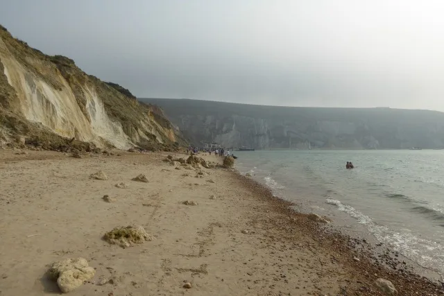
Broomhill Sands is a beach in the United Kingdom.

Simon Carey — CC BY-SA 2.0 via Wikimedia Commons licence

Plan your visit
- Typical visit
- 1 h–3 h
- Best time of year
- Summer (Jun–Aug)
- Nearest railway station
- Romney Sands · 1.0 km
- Free entry
- Family-friendly
- Dog-friendly
Getting there & planning your visit
To visit Broomhill Sands, the nearest railway station is Romney Sands, located approximately 1 km away. The postcode for sat-nav is TN28 8RT, and entry to the beach is free.
About
Broomhill Sands is a beach on the coast of Kent, South-East England. The site is part of the DUNGENESS National Nature Reserve. It sits within the Folkestone and Hythe parliamentary constituency. The nearest railway station is Romney Sands, about 1.0 km away. Postcode area TN28.
Photo gallery
Protected designations
- Site of Special Scientific Interest: Dungeness, Romney Marsh and Rye Bay SSSI
- National Nature Reserve: DUNGENESS
- Ramsar wetland: Dungeness, Romney Marsh and Rye Bay
Designations sourced from Natural England open data under OGL v3.
From the Wikipedia article
Broomhill and Sharrow Vale — which includes the districts of Broomhill, Broomhall, Crookesmoor, Endcliffe, Sharrow Vale and Tapton Hill — is one of the 28 electoral wards in City of Sheffield, England. The ward was created following the 2015 local government boundary review out of parts of the old Broomhill, Central and Nether Edge wards. It is located in the western part of the city. The population of the Broomhill ward in 2011 was 16,966 people in 5,708 households, covering an area of 2.7 km2. Broomhill & Sharrow Vale is one of the wards that make up the Sheffield Central Parliamentary Constituency.
Excerpt from Wikipedia under CC BY-SA 4.0. See the source article linked in Sources below.
Background
History
According to E. Wilkinson: "Most of what is now Broomhill was used as the Crookesmoor Racecourse from 1711 to 1781, the races only being discontinued when the commons of Ecclesall Bierlow were enclosed between 1778 and 1789. Part of Broomhill lay in Nether Hallam, the common land of which was enclosed in 1791. (The parts lying in Nether Hallam are from the north side of Whitham Road to the east side of Crookes Road, and from the bottom of Endcliffe Crescent, Endcliffe Vale Road, Endcliffe Avenue, Oakholme Road, Westbourne Road from below the old Radio Sheffield building and No. 27, Southbourne Road and the north side of Clarkehouse Road from the bottom of Southbourne Road to Brocco Bank.)…
Sourced from Wikipedia under CC BY-SA 4.0.
- Coordinates
- 50.9536, 0.9743
- County
- Kent
- District
- Folkestone and Hythe
- Parish
- Lydd
- Postcode
- TN28 8RT
- Parliamentary constituency
- Folkestone and Hythe
- Nearest railway station
- Romney Sands — 1 km
- Official site
- democracy.sheffield.gov.uk
Sources
- osm: w249700764 (ODbL)
- wikipedia: Broomhill and Sharrow Vale (CC BY-SA 4.0)
Other places nearby

Sea View
Viewpoints · 0.7 km

Plovers
B&Bs · 0.9 km

Romney Sands
Beaches · 1.0 km

Romney Sands Holiday Park
Caravan parks · 1.1 km

Lydd-on-Sea
Towns & cities · 1.1 km

Denge Sound Mirrors
Viewpoints · 1.4 km
30 Foot Sound Mirror
Historic houses · 1.5 km
20 Foot Sound Mirror
Historic houses · 1.5 km

200 foot Sound Mirror
Historic houses · 1.5 km

Greatstone beach
Beaches · 2.7 km

No 1 Battery (Gun emplacement)
Archaeological sites · 2.7 km

Hanson ARC Hide
Viewpoints · 2.9 km
Nearby
📷 5📷 5B&Bs · South East England
Plovers
Plovers — a bed-and-breakfast in england south east.
📷 5Beaches · South East England
Romney Sands
Romney Sands — a beach in england-south-east, United Kingdom.
📷 5Caravan parks · South East England
Romney Sands Holiday Park
Romney Sands Holiday Park — a caravan park in england south east. Brand: Parkdean Resorts.
📷 5📷 5Viewpoints · South East England
Denge Sound Mirrors
Denge Sound Mirrors is a viewpoint in the United Kingdom.
Where to eat & stay near Broomhill Sands
Places to stay
📷 5B&Bs · South East England
Plovers
Plovers — a bed-and-breakfast in england south east.
📷 5Caravan parks · South East England
Romney Sands Holiday Park
Romney Sands Holiday Park — a caravan park in england south east. Brand: Parkdean Resorts.
 📷 5
📷 5Caravan parks · South East England
New Romney Caravan Park
New Romney Caravan Park — a caravan park in england south east.
 📷 5
📷 5Hotels · South East England
The Ship Hotel
The Ship Hotel — a hotel in england south east.
 📷 5
📷 5Campsites · South East England
Romney Meadows Caravan and Camping Park
Romney Meadows Caravan and Camping Park — a campsite in england south east.
📷 5Caravan parks · South East England
Romney Motorhomes Caravans
Romney Motorhomes Caravans — a caravan park in england south east.
Places to eat & drink
 📷 5
📷 5Historic pubs · South East England
The Cinque Port Arms
The Cinque Port Arms in England South East, United Kingdom.
 📷 5
📷 5Historic pubs · South East England
The Fleur De Lys Public House The Fleur-De-Lys-Public House
The Fleur De Lys Public House The Fleur-De-Lys-Public House in England South East, United Kingdom.
 📷 5
📷 5Historic pubs · South East England
Dukes Head Inn
Dukes Head Inn in England South East, United Kingdom.
 📷 5
📷 5Historic pubs · South East England
The Woolpack Inn
The Woolpack Inn in England South East, United Kingdom.
 📷 5
📷 5Historic pubs · South East England
The White Hart Inn
The White Hart Inn in England South East, United Kingdom.
 📷 5
📷 5Historic pubs · South East England
Walnut Tree Inn
Walnut Tree Inn in England South East, United Kingdom.
More beaches in this region
 📷 5
📷 5Beaches · South East England
Abbot's Cliff Beach
Abbot's Cliff Beach is a beach in the United Kingdom.
 📷 5
📷 5Beaches · South East England
Allhallows Beach
Allhallows Beach is a beach in the United Kingdom.
 📷 5
📷 5 📷 5
📷 5Frequently asked questions
- Where is Broomhill Sands?
- Broomhill Sands is in Kent, South-East England, United Kingdom (postcode TN28 8RT), in the parish of Lydd.
- What is Broomhill Sands?
- Broomhill Sands is a beach in the United Kingdom.
- How do I get to Broomhill Sands?
- The nearest railway station is Romney Sands, about 1.0 km away. Drivers can use postcode TN28 8RT.
- Is Broomhill Sands a protected site?
- Yes — Broomhill Sands is part of the Dungeness, Romney Marsh and Rye Bay SSSI Site of Special Scientific Interest and the DUNGENESS National Nature Reserve.
- Is Broomhill Sands free to visit?
- Yes, Broomhill Sands is free to enter.
- How do I get to Broomhill Sands?
- The nearest railway station is Romney Sands, about 1.0 km away. Drivers can navigate to postcode TN28 8RT.