Historic churches · East Midlands
Brookenby Church
Brookenby Church — church in United Kingdom.

Wikimedia Commons contributors — see linked file page for photographer and licence licence
Plan your visit
- Typical visit
- 30 min–1 h
- Free entry
About
Brookenby Church is a historic church in the United Kingdom. Affiliated with Anglicanism. Wikidata describes it as: "church in United Kingdom". Coordinates: 53.4410°, -0.1900°.
Photo gallery
Protected designations
- Site of Special Scientific Interest: Humber Estuary - 2000480 SSSI
- Area of Outstanding Natural Beauty: Lincolnshire Wolds
- Ramsar wetland: Humber Estuary
Designations sourced from Natural England open data under OGL v3.
From the Wikipedia article
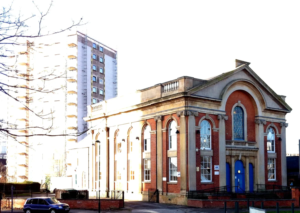
Brookenby Church is located in Brookenby, Lincolnshire, England. A member of the Church of England, it forms part of the Walesby group of churches, which also includes churches in Claxby, Kirmond le Mire, Normanby le Wold, North Willingham, Stainton le Vale, Tealby and Walesby. This group of Churches is within the Diocese of Lincoln. Dedicated to the archangel Saint Michael, Brookenby church was established in the 1990s and is housed in the West wing of a former Officers Mess building. Following the closure of RAF Binbrook, the building was converted to a community centre to serve the newly formed village of Brookenby.
Excerpt from Wikipedia under CC BY-SA 4.0. See the source article linked in Sources below.
- Coordinates
- 53.4410, -0.1900
- County
- Lincolnshire
- District
- West Lindsey
- Parish
- Brookenby
- Postcode
- LN8 6EU
- Parliamentary constituency
- Gainsborough
Sources
- wikidata: Q4974515 (CC0)
- wikipedia: Brookenby Church (CC BY-SA 4.0)
- commons: Brookenby Church.jpg (CC BY-SA 4.0)
Other places nearby
Loading nearby places…
Nearby
 📷 5
📷 5Historic churches · East Midlands
Brookenby
Brookenby — a church in england-east-midlands, United Kingdom.
Caravan parks · East Midlands
Kingsmead Park
Kingsmead Park — a caravan park in england east midlands.
 📷 3
📷 3Archaeological sites · East Midlands
Ash Hill
Ash Hill — a archaeological in england-east-midlands, United Kingdom.
 📷 3
📷 3Archaeological sites · East Midlands
Hoe Hill
Hoe Hill — a archaeological in england-east-midlands, United Kingdom.
 📷 3
📷 3Historic houses · East Midlands
Swinhope House
Swinhope House — house in Swinhope, West Lindsey, Lincolnshire, England, UK.
 📷 5
📷 5Historic churches · East Midlands
Binbrook
Binbrook — a church in england-east-midlands, United Kingdom.
More places in this region
 📷 3
📷 3Historic churches · East Midlands
Addison Street Congregational Church
Addison Street Congregational Church — church in United Kingdom.
 📷 3
📷 3Historic churches · East Midlands
Albion Congregational Church
Albion Congregational Church — church building in Nottingham, Nottinghamshire, England, UK.
 📷 3
📷 3Historic churches · East Midlands
All Hallows' Church, Ordsall
All Hallows' Church, Ordsall — Grade I listed church in Bassetlaw, Nottinghamshire, England, UK.
 📷 3
📷 3Historic churches · East Midlands
All Saints Church
All Saints Church — church in Barrowby, Lincolnshire, England, UK.
Frequently asked questions
- Where is Brookenby Church?
- Brookenby Church is in Lincolnshire, the East Midlands, United Kingdom (postcode LN8 6EU), in the parish of Brookenby.
- Is Brookenby Church a protected site?
- Yes — Brookenby Church is part of the Humber Estuary - 2000480 SSSI Site of Special Scientific Interest and the Lincolnshire Wolds National Landscape (AONB).
- Is Brookenby Church free to visit?
- Yes, Brookenby Church is free to enter.
- How do I get to Brookenby Church?
- Drivers can navigate to postcode LN8 6EU. It sits within the Gainsborough parliamentary constituency.