Cemeteries · Yorkshire & the Humber
Bridlington Cemetery
Also known as: Bridlington
Bridlington Cemetery is a cemetery in the United Kingdom.

Jonathan Thacker — CC BY-SA 2.0 via Wikimedia Commons licence
Plan your visit
- Typical visit
- 30 min–1 h
- Nearest railway station
- Bridlington · 1.3 km
- Free entry
- Dog-friendly
About
Bridlington Cemetery is a cemetery in Yorkshire of architectural and local-history note. The site is a designated Site of Special Scientific Interest. It sits within the Bridlington and The Wolds parliamentary constituency. The nearest railway station is Bridlington, about 1.3 km away. Postcode area YO16.
Photo gallery
Protected designations
- Site of Special Scientific Interest: Flamborough Head SSSI
Designations sourced from Natural England open data under OGL v3.
From the Wikipedia article
Bridlington is a seaside town and civil parish in the East Riding of Yorkshire, England. It is on the Holderness part (Flamborough Head to the Humber estuary) of the Yorkshire Coast by the North Sea. The town is about 28 miles (45 km) north of Hull and 34 miles (55 km) east of York. The stream called Gypsey Race flows through the town and enters the North Sea at the harbour. The Priory Church of St Mary and associated Bayle (or gate) are Grade I listed buildings on the site of an Augustinian Priory. As a sea-fishing port, the town is known for shellfish, and is the largest lobster port in Europe, with over 300 tonnes of the crustaceans landed there each year. It has been termed the "Lobster Capital of Europe". Alongside manufacturing, retail and service firms, its main trade is summer tourism. It holds one of the UK's coastal weather stations.
Excerpt from Wikipedia under CC BY-SA 4.0. See the source article linked in Sources below.
- Coordinates
- 54.0948, -0.1937
- District
- East Riding of Yorkshire
- Parish
- Bridlington
- Postcode
- YO16 7DX
- Parliamentary constituency
- Bridlington and The Wolds
- Nearest railway station
- Bridlington — 1.3 km
- Official site
- www.bridlington.gov.uk
Sources
- osm: w42689616 (ODbL)
- wikipedia: Bridlington (CC BY-SA 4.0)
Other places nearby
Loading nearby places…
Nearby
 📷 3
📷 3Historic churches · Yorkshire & the Humber
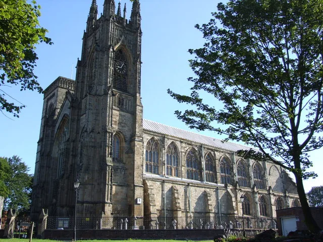
Bridlington Priory
Bridlington Priory — church in Bridlington, East Riding of Yorkshire, England, UK.
 📷 3
📷 3Museums · Yorkshire & the Humber
Bayle Museum
Bayle Museum — Local museum in Bridlington, England.
Caravan parks · Yorkshire & the Humber
Priory Caravan Park
Priory Caravan Park — a caravan park in england yorkshire.
 📷 3
📷 3Historic houses · Yorkshire & the Humber
Craven House
Craven House — house in Bridlington, East Riding of Yorkshire, England, UK.
 📷 3
📷 3Galleries · Yorkshire & the Humber
Alex May Gallery
Alex May Gallery — a gallery in england-yorkshire, United Kingdom.
 📷 3
📷 3Galleries · Yorkshire & the Humber
Morten Gallery
Morten Gallery — a gallery in england-yorkshire, United Kingdom.
More cemeteries in this region
 📷 4
📷 4Cemeteries · Yorkshire & the Humber
Altofts Cemetery
Altofts Cemetery is a cemetery in the United Kingdom.
 📷 3
📷 3Cemeteries · Yorkshire & the Humber
Anlaby Tranby Lane Cemetery
Anlaby Tranby Lane Cemetery is a cemetery in the United Kingdom.
 📷 3
📷 3Cemeteries · Yorkshire & the Humber
Armley Hill Top Cemetery
Armley Hill Top Cemetery is a cemetery in the United Kingdom.
 📷 3
📷 3Cemeteries · Yorkshire & the Humber
Barmby on the Marsh Burial Ground
Barmby on the Marsh Burial Ground is a cemetery in the United Kingdom.
Frequently asked questions
- Where is Bridlington Cemetery?
- Bridlington Cemetery is in Yorkshire, United Kingdom (postcode YO16 7DX), in the parish of Bridlington.
- Is Bridlington Cemetery a protected site?
- Yes — Bridlington Cemetery is part of the Flamborough Head SSSI Site of Special Scientific Interest.
- How do I get to Bridlington Cemetery?
- The nearest railway station is Bridlington, about 1.3 km away. Drivers can navigate to postcode YO16 7DX.