Mountains & hills · South West England
Bridgwater Bay
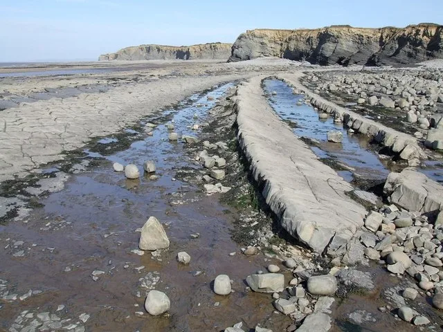
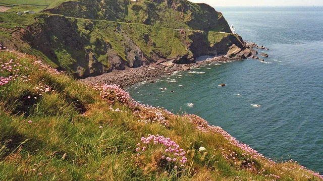
Bridgwater Bay — bay in the Bristol channel, England.

Wikimedia Commons contributors — see linked file page for photographer and licence licence
Plan your visit
- Typical visit
- 3 h–8 h
- Best time of year
- Late spring – early autumn (May–Oct)
- Free entry
- Dog-friendly
About
Bridgwater Bay is a named summit in the United Kingdom. Heritage designation: Site of Special Scientific Interest. Part of Bristol Channel. Wikidata describes it as: "bay in the Bristol channel, England". Coordinates: 51.2500°, -3.2000°.
Photo gallery
From the Wikipedia article
Bridgwater Bay is on the Bristol Channel, 5 kilometres (3.1 mi) north of Bridgwater in Somerset, England at the mouth of the River Parrett and the end of the River Parrett Trail. It stretches from Minehead at the southwestern end of the bay to Brean Down in the north. The area consists of large areas of mudflats, saltmarsh, sandflats and shingle ridges, some of which are vegetated. It has been designated as a Site of Special Scientific Interest (SSSI) covering an area of 3,574.1 hectares (35.741 km2; 13.800 sq mi) since 1989, and is designated as a wetland of international importance under the Ramsar Convention. The risks to wildlife are highlighted in the local Oil Spill Contingency Plan. Several rivers, including the Parrett, Brue and Washford, drain into the bay. Man-made drainage ditches from the Somerset Levels, including the River Huntspill, also run into the bay. The mud flats provide a habitat for a wide range of flora and fauna. These include some nationally rare plants, beetles and snails. It is particularly important for overwintering waders and wildfowl, with approximately 190 species recorded including Eurasian whimbrel (Numenius phaeopus), black-tailed godwit (Limosa limosa), dunlin (Calidris alpina) and wigeon (Anas penelope). Fishing has taken place using shallow boats, known as flatners, and fixed wooden structures for hundreds of years. It was also the last site in England used for 'mudhorse fishing'. There are several small harbours along the coast. The low-lying areas of the bay have been subject to flooding, including the Bristol Channel floods of 1607 and many times since particularly around the Steart Peninsula. In response to this threat sea walls have been built at several points including at Burnham-on-Sea, Berrow and Blue Anchor to Lilstock Coast. The extensive mud flats and high tidal range have been the cause of several drownings and rescue services are now provided by the Burnham Area Rescue Boat.
Excerpt from Wikipedia under CC BY-SA 4.0. See the source article linked in Sources below.
- Coordinates
- 51.2500, -3.2000
Sources
- wikidata: Q4966924 (CC0)
- wikipedia: Bridgwater Bay (CC BY-SA 4.0)
- commons: BridgewaterBay.jpg (CC BY-SA 4.0)
Other places nearby
Loading nearby places…
Nearby
 📷 5
📷 5Villages · South West England
Lilstock
Lilstock — a village in england south west.
 📷 5
📷 5Museums · South West England
River Holford
River Holford — a museum in england-south-west, United Kingdom.
 📷 5
📷 5Beaches · South West England
Kilve Beach
Kilve Beach — beach in the United Kingdom.
 📷 5
📷 5Beaches · South West England
Kilve Beach
Kilve Beach is a beach in the United Kingdom.
Natural landmarks · South West England
Bridgwater Bay
Bridgwater Bay — a natural feature in england south west.
 📷 3
📷 3Archaeological sites · South West England
Pixie's Mound
Pixie's Mound — a archaeological in england-south-west, United Kingdom.
Where to eat & stay near Bridgwater Bay
Places to stay
 📷 5
📷 5Campsites · South West England
Burton Springs
Burton Springs — a campsite in england south west.
 📷 5
📷 5Campsites · South West England
Moorhouse Farm Campsite
Moorhouse Farm Campsite — a campsite in england south west.
 📷 5
📷 5Caravan parks · South West England
Farringdon Hill Caravan Park
Farringdon Hill Caravan Park — a caravan park in england south west.
 📷 2
📷 2Campsites · South West England
St Audries Bay Holiday Club
St Audries Bay Holiday Club — a campsite in england south west.
 📷 5
📷 5Campsites · South West England
Home Farm Holiday Centre
Home Farm Holiday Centre — a campsite in england south west.
 📷 5
📷 5Hotels · South West England
Combe House Hotel
Combe House Hotel — a hotel in england south west.
Places to eat & drink
 📷 5
📷 5Historic pubs · South West England
London Inn
London Inn in England South West, United Kingdom.
 📷 5
📷 5Historic pubs · South West England
West Somerset Hotel
West Somerset Hotel in England South West, United Kingdom.
 📷 5
📷 5Historic pubs · South West England
The Carew Arms And Attached Outbuilding
The Carew Arms And Attached Outbuilding in England South West, United Kingdom.
 📷 5
📷 5Historic pubs · South West England
Lamb Inn
Lamb Inn in England South West, United Kingdom.
 📷 5
📷 5Historic pubs · South Wales
The Captain's Wife
The Captain's Wife in Wales South, United Kingdom.
 📷 5
📷 5Historic pubs · South West England
The Butchers Arms
The Butchers Arms in England South West, United Kingdom.
More mountains in this region
 📷 5
📷 5Mountains & hills · South West England
Alex Tor
Alex Tor — Named summit at 291 m.
 📷 5
📷 5Mountains & hills · South West England
Ash Hole Cavern
Ash Hole Cavern — cave in Brixham, Devon, England, UK.
 📷 5
📷 5Mountains & hills · South West England
Babbacombe Bay
Babbacombe Bay — bay in Devon, England.
 📷 5
📷 5Mountains & hills · South West England
Barley Bay
Barley Bay — bay in the United Kingdom.
Frequently asked questions
- Where is Bridgwater Bay?
- Bridgwater Bay is in South-West England, United Kingdom.
- What is Bridgwater Bay?
- Bridgwater Bay — bay in the Bristol channel, England.
- How do I get to Bridgwater Bay?
- Its coordinates are 51.2500°, -3.2000°.
- Is Bridgwater Bay a listed building?
- Bridgwater Bay is officially recognised as Site of Special Scientific Interest listed.
- Is Bridgwater Bay free to visit?
- Yes, Bridgwater Bay is free to enter.