
Historic bridges · South West England
Bridge And Adjacent Ruin Of Mill 20 Metres South West Of Bilboa House
In or near Mells.
Bridge And Adjacent Ruin Of Mill 20 Metres South West Of Bilboa House — Grade II listed building-listed bridge in england-south-east, United Kingdom.

Neil Owen — CC BY-SA 2.0 via Wikimedia Commons licence

Plan your visit
- Typical visit
- 15 min–30 min
- Nearest railway station
- Frome · 6.3 km
- Free entry
- Dog-friendly
Getting there & planning your visit
The nearest railway station is Frome, located 6.3 km away. The site has free entry and is accessible to visitors. The postcode for navigation is BA11 3QA.
About
Bridge And Adjacent Ruin Of Mill 20 Metres South West Of Bilboa House is a Grade II listed building-listed bridge in england-south-east, United Kingdom, registered on the National Heritage List for England (NHLE entry 1058318). Listed status protects buildings and structures of special architectural or historic interest. See the linked Wikipedia article for further details.
Photo gallery
Heritage listing
Details MELLS CP DOCTORS LANE (North side) ST7249 3/42 Bridge and adjacent ruin of mill 20 metres South West of Bilboa House - GV II Bridge and adjacent ruin of mill. C17, bridge has later alterations. Bridge of Doulting rubble consists of 4 low segmental archways with rough voussoirs, cutwater between each, above at considerable elevation roadway, rubble parapets with cement capping. Broader segmental arch at north end connected to former leat, mill adjacent to west side. Ruined mill consists of 2 single bay structures of 3-storeys each, both missing roofs and floors, sore segmental head bead moulded stone mullioned windows, others with ovolo mouldings. Remains of mill machinery adjacent to leat. Included primarily for group value. Listing NGR: ST7226048965 Legacy The contents of this record have been generated from a legacy data system. Legacy System number: 266742 Legacy System: LBS
From the Historic England List Entry under OGL v3.
Place summary
The Bridge and adjacent ruin of Mill, located 20 metres south-west of Bilboa House in Mells, South-East England, is a Grade II listed building. It represents a notable example of historic infrastructure in the area.
AI-generated from the structured facts on this page (operator, designation, listing, era). Not a substitute for visiting.
- Coordinates
- 51.2392, -2.3987
- District
- Somerset
- Parish
- Mells
- Postcode
- BA11 3QA
- Parliamentary constituency
- Frome and East Somerset
- Nearest railway station
- Frome — 6.3 km
Sources
- wikidata: Q26310423 (CC0)
Other places nearby

The Talbot Inn
Historic pubs · 0.6 km
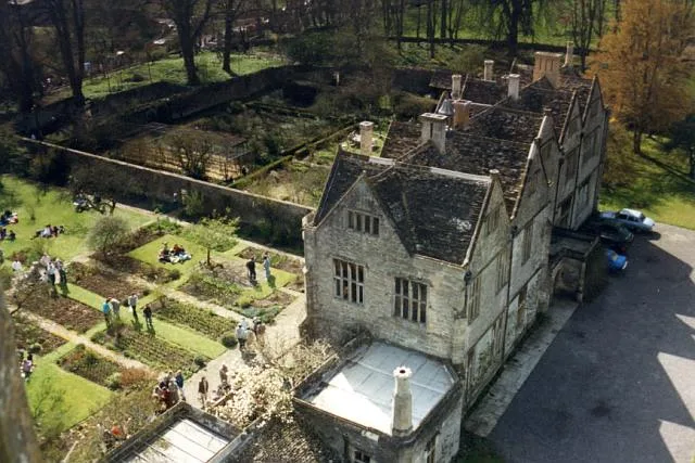
Mells Manor
Stately homes · 0.6 km

St Andrew's Church, Mells
Historic churches · 0.6 km

Mells War Memorial
Memorials & monuments · 0.7 km

Mells
Towns & cities · 0.7 km

Whatley Quarry
Quarries · 1.4 km

Wadbury Camp
Vineyards · 1.5 km

Old Iron Works, Mells
Museums · 1.5 km
Fussells Iron Works (ruins)
Archaeological sites · 1.6 km

Vobster Inn Bridge
Historic bridges · 1.7 km

Manor Farmhouse Gatehouse
Farms (open to visitors) · 1.8 km

Newbury Hill
Mountains & hills · 1.8 km
Nearby
📷 5Historic pubs · South West England
The Talbot Inn
The Talbot Inn in England South West, United Kingdom.
Flagship📷 10Stately homes · South West England
Mells Manor
Mells Manor — Grade I listed house in Mells, Somerset, England, UK.
📷 5Historic churches · South West England
St Andrew's Church, Mells
St Andrew's Church, Mells — church in Mells, Somerset, England, UK.
📷 5Memorials & monuments · South West England
Mells War Memorial
Mells War Memorial — Grade II* listed building-listed memorial in england-south-east, United Kingdom.
📷 5Towns & cities · South West England
Mells
Mells — village and civil parish in Somerset, UK.
📷 5Where to eat & stay near Bridge And Adjacent Ruin Of Mill 20 Metres South West Of Bilboa House
Places to stay
 📷 5
📷 5 📷 5
📷 5 📷 5
📷 5Hotels · South West England
The Radstock Hotel
The Radstock Hotel — a hotel in england south east.
 📷 5
📷 5Campsites · South West England
Pitchperfect
Pitchperfect — a campsite in england south east.
 📷 5
📷 5B&Bs · South West England
The Old Priory
The Old Priory — a bed-and-breakfast in england south east.
 📷 7
📷 7Hotels · South West England
The Woolpack Inn
The Woolpack Inn — a hotel in england south east.
Places to eat & drink
📷 5Historic pubs · South West England
The Talbot Inn
The Talbot Inn in England South West, United Kingdom.
 📷 5
📷 5 📷 7
📷 7Historic pubs · South West England
The Jolliffe Arms And Nos 235 And 236
The Jolliffe Arms And Nos 235 And 236 in England South West, United Kingdom.
 📷 7
📷 7Restaurants · South West England
The Old Bath Arms
The Old Bath Arms — a restaurant in england south east.
 📷 6
📷 6Historic pubs · South West England
The Three Swan's Inn
The Three Swan's Inn in England South West, United Kingdom.
 📷 7
📷 7More bridges in this region
 📷 5
📷 5Historic bridges · South West England
Avoncliff Aqueduct
Avoncliff Aqueduct is a historic bridge in the United Kingdom.
📷 5Historic bridges · South West England
Avoncliff Aqueduct
Avoncliff Aqueduct is a historic bridge in the United Kingdom.
 📷 5
📷 5Historic bridges · South West England
Bradford Viaduct
Bradford Viaduct is a historic bridge in the United Kingdom.
 📷 5
📷 5Historic bridges · South West England
Chippenham Viaduct
Chippenham Viaduct is a historic bridge in the United Kingdom.
Frequently asked questions
- Where is Bridge And Adjacent Ruin Of Mill 20 Metres South West Of Bilboa House?
- Bridge And Adjacent Ruin Of Mill 20 Metres South West Of Bilboa House is in South-East England, United Kingdom (postcode BA11 3QA), in the parish of Mells.
- What is Bridge And Adjacent Ruin Of Mill 20 Metres South West Of Bilboa House?
- Bridge And Adjacent Ruin Of Mill 20 Metres South West Of Bilboa House — Grade II listed building-listed bridge in england-south-east, United Kingdom.
- How do I get to Bridge And Adjacent Ruin Of Mill 20 Metres South West Of Bilboa House?
- The nearest railway station is Frome, about 6.3 km away. Drivers can use postcode BA11 3QA.
- Is Bridge And Adjacent Ruin Of Mill 20 Metres South West Of Bilboa House a listed building?
- Bridge And Adjacent Ruin Of Mill 20 Metres South West Of Bilboa House is officially recognised as Grade II listed building listed.
- Is Bridge And Adjacent Ruin Of Mill 20 Metres South West Of Bilboa House free to visit?
- Yes, Bridge And Adjacent Ruin Of Mill 20 Metres South West Of Bilboa House is free to enter.
- How do I get to Bridge And Adjacent Ruin Of Mill 20 Metres South West Of Bilboa House?
- The nearest railway station is Frome, about 6.3 km away. Drivers can navigate to postcode BA11 3QA.