
Museums · East Midlands
Borough of Chesterfield
In or near Calow.
The Borough of Chesterfield is a non-metropolitan district with borough status in Derbyshire, England. It is named after the town of Chesterfield, its largest town, and also contains the town of Stave

Andrew Hill — CC BY-SA 2.0 via Wikimedia Commons licence

Plan your visit
- Typical visit
- 1.5 h–3 h
- Best time of year
- Year-round
- Nearest railway station
- Chesterfield · 0.6 km
- Family-friendly
- Limited wheelchair access
Getting there & planning your visit
The Borough of Chesterfield is located in Chesterfield, Derbyshire, with the postcode S41 0EN. The nearest railway station is Chesterfield, which is 0.6 km away. Entry is free, but wheelchair accessibility is limited.
About
The Borough of Chesterfield is a non-metropolitan district with borough status in Derbyshire, England. It is named after the town of Chesterfield, its largest town, and also contains the town of Staveley and the villages of Barrow Hill, Brimington, Duckmanton, Hollingwood, New Whittington, Netherthorpe, Old Whittington and Tapton. In 2022 it had a population of 104,110. The borough borders the North East Derbyshire district to the north, west and south, and the Bolsover district to the east.
Photo gallery
From the Wikipedia article
The Borough of Chesterfield is a non-metropolitan district with borough status in Derbyshire, England. It is named after the town of Chesterfield, its largest town, and also contains the town of Staveley and the villages of Barrow Hill, Brimington, Duckmanton, Hollingwood, New Whittington, Netherthorpe, Old Whittington and Tapton. In 2022 it had a population of 104,110. The borough borders the North East Derbyshire district to the north, west and south, and the Bolsover district to the east.
Excerpt from Wikipedia under CC BY-SA 4.0. See the source article linked in Sources below.
Background
History
The town of Chesterfield had been an ancient borough. It was reformed to become a municipal borough in 1836 under the Municipal Corporations Act 1835, governed by a corporate body called "the mayor, aldermen and burgesses of the borough of Chesterfield", generally known as the corporation or town council. The modern district was formed on 1 April 1974 under the Local Government Act 1972 as one of nine non-metropolitan districts within Derbyshire. The new district covered the area of two former districts and a single parish from a third, which were all abolished at the same time: The new district was named Chesterfield after its largest town. The new Chesterfield district was granted borough…
Sourced from Wikipedia under CC BY-SA 4.0.
- Coordinates
- 53.2333, -1.4167
- County
- Derbyshire
- District
- Chesterfield
- Parish
- Chesterfield, unparished area
- Postcode
- S41 0EN
- Parliamentary constituency
- Chesterfield
- Nearest railway station
- Chesterfield — 0.6 km
Sources
- wikipedia: Borough of Chesterfield (CC BY-SA 4.0)
Other places nearby

Travelodge
Hotels · 0.4 km

Hidden Fruit
Public art & sculpture · 0.4 km

Growth
Public art & sculpture · 0.5 km

The Snail
Public art & sculpture · 0.5 km

Pomegranate Theatre
Theatres · 0.6 km

Pomegranate Theatre
Open-air theatres · 0.6 km

Chesterfield Museum
Museums · 0.6 km
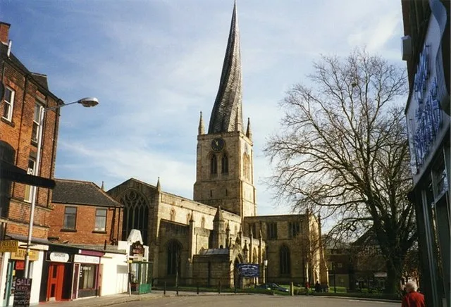
Church of St Mary and All Saints, Chesterfield
Historic churches · 0.6 km
Chesterfield Museum and Art Gallery
Museums · 0.6 km

War Memorial in Churchyard to North East of St Mary's Church
Memorials & monuments · 0.6 km

Ginnners
Distilleries · 0.6 km
Winding Wheel
Theatres · 0.7 km
Nearby
📷 7📷 3Public art & sculpture · East Midlands
Hidden Fruit
Hidden Fruit — a public art in england-east-midlands, United Kingdom.
📷 3Public art & sculpture · East Midlands
Growth
Growth — a public art in england-east-midlands, United Kingdom.
📷 3Public art & sculpture · East Midlands
The Snail
The Snail — a public art in england-east-midlands, United Kingdom.
📷 3📷 5Open-air theatres · East Midlands
Pomegranate Theatre
Pomegranate Theatre — a open-air theatre in england east midlands.
Where to eat & stay near Borough of Chesterfield
Places to stay
📷 7 📷 5
📷 5Hotels · East Midlands
Ringwood Hall Hotel
Ringwood Hall Hotel — a hotel in england east midlands.
 📷 5
📷 5Caravan parks · East Midlands
Caravan Club Site - Poolsbrook
Caravan Club Site - Poolsbrook — a caravan park in england east midlands.
 📷 5
📷 5Caravan parks · East Midlands
Timberland Motorhomes
Timberland Motorhomes — a caravan park in england east midlands.
 📷 5
📷 5Caravan parks · East Midlands
Brookfield Mobile Home Park
Brookfield Mobile Home Park — a caravan park in england east midlands.
 📷 5
📷 5Caravan parks · East Midlands
Millfield Mobile Home Park
Millfield Mobile Home Park — a caravan park in england east midlands.
Places to eat & drink
 📷 5
📷 5Historic pubs · East Midlands
The Royal Oak Inn
The Royal Oak Inn in England East Midlands, United Kingdom.
 📷 7
📷 7Historic pubs · East Midlands
The Nags Head Public House
The Nags Head Public House in England East Midlands, United Kingdom.
 📷 5
📷 5Historic pubs · East Midlands
The Crispin Inn
The Crispin Inn in England East Midlands, United Kingdom.
 📷 5
📷 5Historic pubs · East Midlands
The Miners Arms Public House
The Miners Arms Public House in England East Midlands, United Kingdom.
 📷 3
📷 3Restaurants · East Midlands
The Old Vicarage, Derbyshire
The Old Vicarage is a restaurant located in Ridgeway, near Sheffield. The restaurant held one star in the Michelin Guide from 1998 to 2015. The head chef is TV chef Tessa Bramley.
 📷 5
📷 5Historic pubs · Yorkshire & the Humber
Bagshawe Arms Public House
Bagshawe Arms Public House in England Yorkshire, United Kingdom.
More museums in this region
 📷 5
📷 5Museums · East Midlands
Stamford Town Hall
Stamford Town Hall — building in Stamford, Lincolnshire, England, UK.
 📷 5
📷 5Museums · East Midlands
Thorney Museum
Thorney Museum — a museum in england-london, United Kingdom.
 📷 5
📷 5Museums · East Midlands
Octavia Hill Birthplace Museum
Octavia Hill Birthplace Museum — a museum in england-london, United Kingdom.
 📷 5
📷 5Museums · East Midlands
Museum of Technology
Museum of Technology — a museum in england-london, United Kingdom.
Frequently asked questions
- Where is Borough of Chesterfield?
- Borough of Chesterfield is in Derbyshire, the East Midlands, United Kingdom (postcode S41 0EN), in the parish of Chesterfield, unparished area.
- What is Borough of Chesterfield?
- The Borough of Chesterfield is a non-metropolitan district with borough status in Derbyshire, England. It is named after the town of Chesterfield, its largest town, and also contains the town of Stave
- How do I get to Borough of Chesterfield?
- The nearest railway station is Chesterfield, about 0.6 km away. Drivers can use postcode S41 0EN.
- How do I get to Borough of Chesterfield?
- The nearest railway station is Chesterfield, about 0.6 km away. Drivers can navigate to postcode S41 0EN.