Mountains & hills · Central Scotland
Blyth Muir
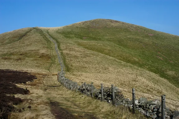
Blyth Muir — mountain in scotland central. Elevation: 310 m.

Jim Barton — CC BY-SA 2.0 via Wikimedia Commons licence
Plan your visit
- Typical visit
- 3 h–8 h
- Best time of year
- Late spring – early autumn (May–Oct)
About
Blyth Muir is a mountain located in scotland central. Elevation: 310 m. A named British peak recorded in OpenStreetMap. Peaks are typically named on Ordnance Survey 1:50k mapping.
Photo gallery
Place summary
Blyth Muir is a mountain located in central Scotland. It is part of the Southern Uplands, known for its rugged terrain and natural beauty. Visitors can expect a range of walking opportunities in the surrounding area, with varied landscapes and potential wildlife sightings. The location is suitable for experienced hikers and those looking for a more remote outdoor experience.
AI-generated from the structured facts on this page (operator, designation, listing, era). Not a substitute for visiting.
- Coordinates
- 55.7122, -3.3805
Sources
- osm: n3530257034 (ODbL)
Other places nearby
Loading nearby places…
Nearby
📷 5Mountains & hills · Central Scotland
Blyth Muir
Blyth Muir — a hill or mountain in scotland central.
 📷 5
📷 5Vineyards · Central Scotland
Blyth Bank Hill
Blyth Bank Hill — a UK vineyard in scotland central, producing English or Welsh wine from cool-climate grape varieties.
 📷 3
📷 3Forts · Central Scotland
Blyth Bank Hill
Blyth Bank Hill is a fort in the United Kingdom.
 📷 3
📷 3Archaeological sites · Central Scotland
Blyth Hill
Blyth Hill — a archaeological in scotland-central, United Kingdom.
 📷 5
📷 5Archaeological sites · Central Scotland
Blyth Hill
Blyth Hill — archaeological in scotland central. Elevation: 308 m.
 📷 5
📷 5Watermills · Central Scotland
Blyth Mill
Blyth Mill — category B listed building-listed watermill in scotland-central, United Kingdom.
Where to eat & stay near Blyth Muir
Places to stay
 📷 5
📷 5Hotels · Central Scotland
Allan Ramsay Hotel
Allan Ramsay Hotel — a hotel in scotland central.
 📷 5
📷 5Hotels · Central Scotland
Barony Castle Hotel
Barony Castle Hotel — a hotel in scotland central.
 📷 5
📷 5Hotels · Central Scotland
Cringletie House Hotel
Cringletie House Hotel — a hotel in scotland central.
 📷 5
📷 5Caravan parks · Central Scotland
Rosetta Holiday Park
Rosetta Holiday Park — a caravan park in scotland central.
 📷 5
📷 5Caravan parks · Central Scotland
Crossburn Caravan Park
Crossburn Caravan Park — a caravan park in scotland central.
 📷 5
📷 5Hotels · Central Scotland
The Elphinstone Hotel
The Elphinstone Hotel — a hotel in scotland central.
Places to eat & drink
 📷 5
📷 5Restaurants · Central Scotland
Horse Shoe Inn
Horse Shoe Inn — a restaurant in scotland central.
 📷 5
📷 5Historic pubs · Central Scotland
Red Lion House, 36 Biggiesknowe, Peebles
Red Lion House, 36 Biggiesknowe, Peebles in Scotland Central, United Kingdom.
 📷 5
📷 5Historic pubs · Central Scotland
The Bridge Inn, West Port, Peebles
The Bridge Inn, West Port, Peebles in Scotland Central, United Kingdom.
 📷 5
📷 5Historic pubs · Central Scotland
The Keg Lounge Bar, 11 High Street, Peebles
The Keg Lounge Bar, 11 High Street, Peebles in Scotland Central, United Kingdom.
 📷 5
📷 5Historic pubs · Central Scotland
74 Main Street, Carnwath
74 Main Street, Carnwath in Scotland Central, United Kingdom.
 📷 5
📷 5Historic pubs · Central Scotland
Craigiebield House Hotel, 50 Bog Road, Penicuik
Craigiebield House Hotel, 50 Bog Road, Penicuik in Scotland Central, United Kingdom.
More mountains in this region
 📷 3
📷 3Mountains & hills · Central Scotland
Abbey Hill
Abbey Hill — Named summit at 278 m.
 📷 3
📷 3Mountains & hills · Central Scotland
Aberlady Bay
Aberlady Bay — bay on the north coast of East Lothian, Scotland, UK.
 📷 3
📷 3Mountains & hills · Central Scotland
Allermuir Hill
Allermuir Hill — Named summit at 493 m.
 📷 3
📷 3Mountains & hills · Central Scotland
Ardnandave
Ardnandave — Named summit at 715 m.
Frequently asked questions
- Where is Blyth Muir?
- Blyth Muir is in central Scotland, United Kingdom.
- What is Blyth Muir?
- Blyth Muir — mountain in scotland central. Elevation: 310 m.
- How do I get to Blyth Muir?
- Its coordinates are 55.7122°, -3.3805°.