Reservoirs & lochs · North East England
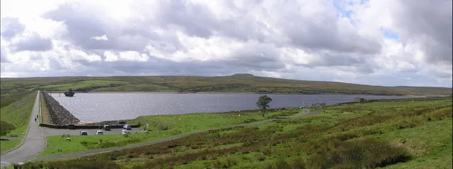
Blencarn
In or near Newbiggin.
Blencarn in England North East, United Kingdom.

Mike Rayner — CC BY-SA 2.0 via Wikimedia Commons licence
Plan your visit
- Typical visit
- 1 h–2.5 h
- Nearest railway station
- Langwathby · 6.9 km
- Free entry
- Dog-friendly
About
Blencarn is a place of interest in England North East, United Kingdom — drawn from open-data sources for visitor reference. See the linked Wikipedia article for the full description.
Photo gallery
Protected designations
- Site of Special Scientific Interest: River Eden and Tributaries SSSI
- Site of Special Scientific Interest: Moorhouse and Cross Fell SSSI
- Area of Outstanding Natural Beauty: North Pennines
Designations sourced from Natural England open data under OGL v3.
From the Wikipedia article
Blencarn is a village in the civil parish of Culgaith, in the Westmorland and Furness district, in the ceremonial county of Cumbria, England. The village is situated at the foot of the Pennines. It has a small village hall that used to be a school. In Blencarn there is fly fishing at the 15-acre (61,000 m2) Blencarn lake.
Excerpt from Wikipedia under CC BY-SA 4.0. See the source article linked in Sources below.
Background
History
There has been activity near Blencarn as early as the Roman era. An old Roman road known as Maiden Way once ran nearby and 1.27 km northeast near the farm of Ranbeck lies various ancient "cultivation terraces" known as "The Hanging Walls of Mark Antony". Blencarn is marked as "Blenkerne" on Christopher Saxton’s 1579 map of Westmorland and Cumberland, as "Blenkern" on a 1760 map of the area and as its current name on Carry's 1794 map of England, Scotland and Wales.
Sourced from Wikipedia under CC BY-SA 4.0.
- Coordinates
- 54.6750, -2.5620
- District
- Westmorland and Furness
- Parish
- Culgaith
- Postcode
- CA10 1TX
- Parliamentary constituency
- Penrith and Solway
- Nearest railway station
- Langwathby — 6.9 km
Sources
Other places nearby

Kirkland
Natural landmarks · 1.6 km

Hanging Walls Of Mark Anthony
Archaeological sites · 1.7 km

Barons Hill
Mountains & hills · 1.7 km

Skirwith
Abbeys & priories · 1.9 km
Willie Hill
Mountains & hills · 2.0 km

Skirwith
Villages · 2.3 km

The Abbey, Skirwith
Abbeys & priories · 2.5 km

Tottle Hill
Mountains & hills · 2.5 km

Milburn
Memorials & monuments · 2.6 km

Newbiggin Hall
Historic houses · 2.8 km

Bridge To North West Of Newbiggin Hall
Historic bridges · 2.8 km

Wiythwaite Top
Mountains & hills · 2.8 km
Nearby
📷 5📷 3Archaeological sites · North East England
Hanging Walls Of Mark Anthony
Hanging Walls Of Mark Anthony — a archaeological in scotland-lowlands, United Kingdom.
📷 5Mountains & hills · North East England
Barons Hill
Barons Hill — mountain in scotland lowlands. Elevation: 220 m.
Flagship📷 5📷 5Mountains & hills · North East England
Willie Hill
Willie Hill — mountain in scotland lowlands. Elevation: 239 m.
📷 5Where to eat & stay near Blencarn
Places to stay
 📷 5
📷 5Caravan parks · North East England
Crossfell Caravan Park
Crossfell Caravan Park — a caravan park in scotland lowlands.
 📷 5
📷 5Hotels · North West England
Kings Arms Hotel
Kings Arms Hotel — a hotel in scotland lowlands.
 📷 5
📷 5Caravan parks · North East England
Silverband Caravan Park
Silverband Caravan Park — a caravan park in scotland lowlands.
 📷 5
📷 5Caravan parks · North East England
Low Moor Caravan and Campsite
Low Moor Caravan and Campsite — a caravan park in scotland lowlands.
 📷 5
📷 5Caravan parks · North East England
Melmerby Holiday Park
Melmerby Holiday Park — a caravan park in scotland lowlands.
 📷 5
📷 5Caravan parks · North West England
Melmerby Mill Holiday Caravan Park
Melmerby Mill Holiday Caravan Park — a caravan park in scotland lowlands.
Places to eat & drink
 📷 3
📷 3 📷 5
📷 5Historic pubs · North East England
1, Scattergate
1, Scattergate in England North East, United Kingdom.
 📷 7
📷 7Historic pubs · North West England
Two Lions public house and integral stables
Two Lions public house and integral stables in Scotland Lowlands, United Kingdom.
 📷 7
📷 7Cafés · North West England
Narrowbar Cafe
Narrowbar Cafe — a café in scotland lowlands.
 📷 6
📷 6Historic pubs · North West England
Gloucester Arms
Gloucester Arms in Scotland Lowlands, United Kingdom.
 📷 5
📷 5Historic pubs · North West England
Horse And Farrier Inn And Stables
Horse And Farrier Inn And Stables in Scotland Lowlands, United Kingdom.
More places in this region
 📷 2
📷 2Reservoirs & lochs · North East England
Balderhead Reservoir
Balderhead Reservoir — reservoir in County Durham, England, UK.
 📷 3
📷 3Reservoirs & lochs · North East England
Blackton Reservoir
Blackton Reservoir — reservoir in County Durham, England, UK.
 📷 5
📷 5Reservoirs & lochs · North East England
Grassholme Reservoir
Grassholme Reservoir — reservoir in County Durham, England, UK.
 📷 3
📷 3Reservoirs & lochs · North East England
Hury Reservoir
Hury Reservoir — reservoir in County Durham, England, UK.
Frequently asked questions
- Where is Blencarn?
- Blencarn is in North-East England, United Kingdom (postcode CA10 1TX), in the parish of Culgaith.
- What is Blencarn?
- Blencarn in England North East, United Kingdom.
- How do I get to Blencarn?
- The nearest railway station is Langwathby, about 6.9 km away. Drivers can use postcode CA10 1TX.
- Is Blencarn a protected site?
- Yes — Blencarn is part of the River Eden and Tributaries SSSI Site of Special Scientific Interest and the Moorhouse and Cross Fell SSSI Site of Special Scientific Interest.
- Is Blencarn free to visit?
- Yes, Blencarn is free to enter.
- How do I get to Blencarn?
- The nearest railway station is Langwathby, about 6.9 km away. Drivers can navigate to postcode CA10 1TX.