
Mountains & hills · Central Scotland
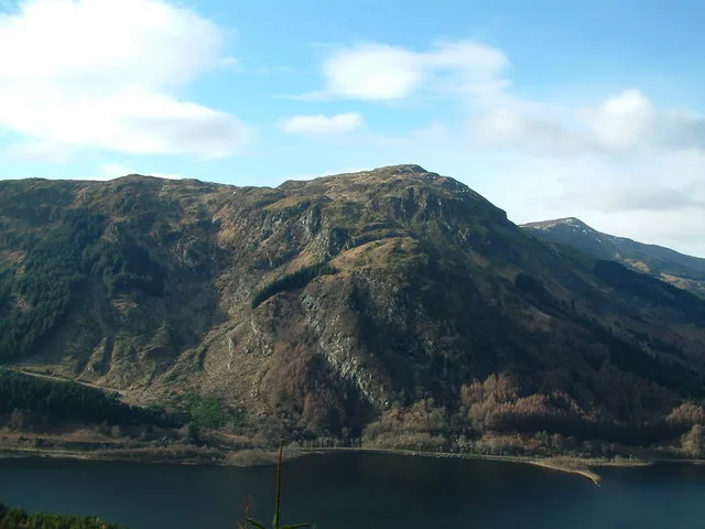
Benvane
Also known as: Beinn Bhan
In or near Brig o' Turk.
Benvane — Named summit at 821 m.

Wikimedia Commons contributors — see linked file page for photographer and licence licence

Plan your visit
- Typical visit
- 3 h–8 h
- Best time of year
- Late spring – early autumn (May–Oct)
- Free entry
- Dog-friendly
About
Benvane is a named summit in the United Kingdom. Also known as: Beinn Bhan. Wikidata describes it as: "Named summit at 821 m.". Coordinates: 56.2933°, -4.3685°.
Photo gallery
From the Wikipedia article
Benvane (Scottish Gaelic: Beinn Bhàn) is a mountain in the Trossachs, in Stirling council area, Scotland. It lies within Loch Lomond and The Trossachs National Park and the Queen Elizabeth Forest Park, and the summit is on the western boundary of the Trossachs National Nature Reserve. It is 821 metres (2,694 ft) high, and is classified as a Corbett, being joined by a ridge to the neighbouring Corbett of Ben Ledi. Benvane may be climbed by several routes, which can be combined to make for a circular route. From the south the summit can be reached via the 6 km-long ridge that connects it to Ben Ledi: the bealach between the two peaks can be reached via Ben Ledi itself or directly: either from the Stank Glen on the west side of this ridge, ascending from the shores of Loch Lubaig; or from Brig o' Turk via the Glen Finglas reservoir and Glen Casaig. Brig o' Turk also serves as the start point for a route ascending directly to Benvane's summit via its south ridge. On the northern side of the hill there are also routes from Strathyre, and from Glen Buckie near Balquhidder via a route up the hill's north ridge. The Ben Ledi-Benvane ridge marks the boundary between West Strathyre estate (owned by Forestry and Land Scotland), and Glen Finglas Estate, which is owned by the Woodland Trust.
Excerpt from Wikipedia under CC BY-SA 4.0. See the source article linked in Sources below.
- Coordinates
- 56.2933, -4.3685
- Address
- Stirling, Scotland
Sources
- osm: n268132129 (ODbL)
- wikipedia: Benvane (CC BY-SA 4.0)
- commons: Benvane from its south ridge - geograph.org.uk - 1396307.jpg (CC BY-SA 4.0)
Other places nearby

Sput Beag
Natural landmarks · 2.0 km

Stùc Dhubh
Mountains & hills · 2.2 km
Sput Mor
Natural landmarks · 2.2 km

Am Fireach
Mountains & hills · 2.8 km

Meall Cala
Mountains & hills · 2.9 km

River Balvag
Reservoirs & lochs · 3.0 km

Bioran na Circe
Mountains & hills · 3.0 km

Gleann Dubh
Gorges · 3.1 km

Ardnandave Hill
Mountains & hills · 3.4 km
Ardnandave
Mountains & hills · 3.4 km

Immervoulin Caravan & Campsite
Campsites · 3.5 km

An Sìthean
Mountains & hills · 3.7 km
Nearby
📷 3📷 5Mountains & hills · Central Scotland
Stùc Dhubh
Stùc Dhubh — mountain in scotland central. Elevation: 662 m.
📷 3📷 5Mountains & hills · Central Scotland
Am Fireach
Am Fireach — a mountain in scotland-central, United Kingdom.
📷 3Mountains & hills · Central Scotland
Meall Cala
Meall Cala — a mountain in scotland-central, United Kingdom.
📷 4Reservoirs & lochs · Central Scotland
River Balvag
River Balvag in Scotland Islands, United Kingdom.
Where to eat & stay near Benvane
Places to stay
📷 5Campsites · Central Scotland
Immervoulin Caravan & Campsite
Immervoulin Caravan & Campsite — a campsite in scotland central.
 📷 5
📷 5Campsites · Central Scotland
Loch Katrine Eco Camp
Loch Katrine Eco Camp — a campsite in scotland central.
 📷 5
📷 5Campsites · Central Scotland
Falls of Leny Campsite
Falls of Leny Campsite — a campsite in scotland central.
 📷 5
📷 5Hostels · Central Scotland
Loch Voil Hostel
Loch Voil Hostel — a hostel in scotland central.
 📷 5
📷 5Campsites · Central Scotland
Loch Achray South camping permit area March-September
Loch Achray South camping permit area March-September — a campsite in scotland central.
 📷 5
📷 5Campsites · Central Scotland
Loch Achray Campsite
Loch Achray Campsite — a campsite in scotland central.
Places to eat & drink
 📷 5
📷 5Historic pubs · Central Scotland
The Drovers Inn
The Drovers Inn — Historic pub — listed building or notable heritage status.
More mountains in this region
 📷 3
📷 3 📷 3
📷 3 📷 3
📷 3Mountains & hills · Central Scotland
An Caisteal
An Caisteal — Named summit at 995 m.
 📷 5
📷 5Frequently asked questions
- Where is Benvane?
- Benvane is in central Scotland, United Kingdom.
- What is Benvane?
- Benvane — Named summit at 821 m.
- How do I get to Benvane?
- The nearest town is Brig o' Turk. Its coordinates are 56.2933°, -4.3685°.
- Is Benvane free to visit?
- Yes, Benvane is free to enter.