
Mountains & hills · Central Scotland
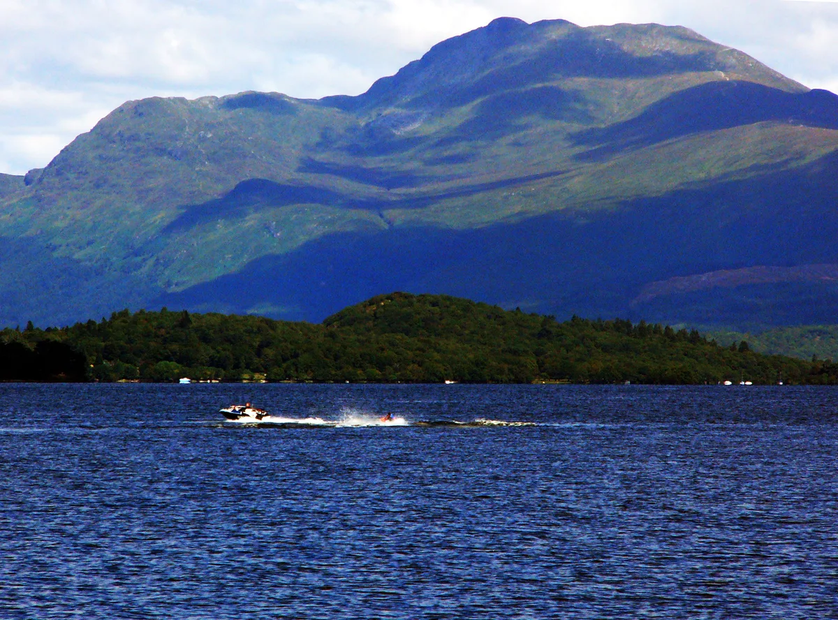
Ben Lomond
Also known as: Beinn Laomainn
In or near Tarbet.
Ben Lomond — Named summit at 974 m.

Wikimedia Commons contributors — see linked file page for photographer and licence licence

Plan your visit
- Typical visit
- 3 h–8 h
- Best time of year
- Late spring – early autumn (May–Oct)
- Nearest railway station
- Arrochar and Tarbet · 5.7 km
- Free entry
- Dog-friendly
Getting there & planning your visit
To visit Ben Lomond in the Scottish Highlands, the nearest railway station is Arrochar and Tarbet, which is 5.7 km away. Entry to the mountain is free.
About
Ben Lomond is a named summit in the United Kingdom. Also known as: Beinn Laomainn. Wikidata describes it as: "Named summit at 974 m.". Coordinates: 56.1904°, -4.6333°.
Photo gallery
Official information
Ben Lomond is a popular mountain located in Scotland, known for its stunning views and hiking trails. Visitors can enjoy various routes to the summit, including the well-trodden tourist path and the more challenging Ptarmigan Ridge.
From the Wikipedia article
Ben Lomond (Scottish Gaelic: Beinn Laomainn, lit. 'Beacon Mountain'), 974 metres (3,196 ft), is a mountain in the Scottish Highlands. Situated on the eastern shore of Loch Lomond, it is the most southerly of the Munros. Ben Lomond lies within the Ben Lomond National Memorial Park and the Loch Lomond and The Trossachs National Park, property of the National Trust for Scotland. Its accessibility from Glasgow and elsewhere in central Scotland, together with the relative ease of ascent from Rowardennan, makes it one of the most popular of all the Munros: it is estimated that around 30,000 people reach the summit each year. On a clear day, it is visible from the higher grounds of Glasgow and across Strathclyde. Ben Lomond's summit can also be seen from Ben Nevis, the highest peak in Britain, over 40 miles (64 km) away. The West Highland Way runs along the western base of the mountain, by the loch. Ben Lomond's popularity in Scotland has resulted in several namesakes in the former British colonies Australia, Canada, New Zealand, Jamaica, Trinidad and Tobago, and the United States – see this list. The mountain is mentioned directly in the popular folk song "The Bonnie Banks o' Loch Lomond".
Excerpt from Wikipedia under CC BY-SA 4.0. See the source article linked in Sources below.
- Coordinates
- 56.1904, -4.6333
- Nearest railway station
- Arrochar and Tarbet — 5.7 km
- Official site
- www.hill-bagging.co.uk
Sources
- osm: n25697071 (ODbL)
- wikipedia: Ben Lomond (CC BY-SA 4.0)
- commons: Loch Lomond Lomond Mountain.jpg (CC BY-SA 4.0)
Other places nearby
Ben Lomond
Natural landmarks · 0.0 km

Ptarmigan
Mountains & hills · 0.7 km

Ptarmigan
Mountains & hills · 1.1 km

Cruinn a' Bheinn
Mountains & hills · 2.2 km

Creag Bhocarn
Mountains & hills · 2.3 km

Creag a' Bhocain
Mountains & hills · 2.3 km

Sron Aonaich
Mountains & hills · 2.5 km

Beinn Bhan
Mountains & hills · 3.0 km
Beinn a' Bhan
Mountains & hills · 3.2 km

Firkin Point D Wild camping permit area March-September
Campsites · 3.4 km
Buchanan
Reservoirs & lochs · 3.4 km

Firkin Point C camping permit area March-September
Campsites · 3.5 km
Nearby
📷 4Natural landmarks · Central Scotland
Ben Lomond
Ben Lomond — mountain in Stirling, Scotland, UK.
📷 3Mountains & hills · Central Scotland
Ptarmigan
Ptarmigan — a mountain in scotland-highlands, United Kingdom.
📷 5Mountains & hills · Central Scotland
Ptarmigan
Ptarmigan — mountain in scotland highlands. Elevation: 731 m.
📷 3Mountains & hills · Central Scotland
Cruinn a' Bheinn
Cruinn a' Bheinn — a mountain in scotland-highlands, United Kingdom.
📷 5Mountains & hills · Central Scotland
Creag Bhocarn
Creag Bhocarn — mountain in scotland highlands. Elevation: 491 m.
📷 5Mountains & hills · Central Scotland
Creag a' Bhocain
Creag a' Bhocain — a hill or mountain in scotland highlands.
Where to eat & stay near Ben Lomond
Places to stay
📷 5Campsites · Central Scotland
Firkin Point D Wild camping permit area March-September
Firkin Point D Wild camping permit area March-September — a campsite in scotland highlands.
📷 5Campsites · Central Scotland
Firkin Point C camping permit area March-September
Firkin Point C camping permit area March-September — a campsite in scotland highlands.
📷 5Caravan parks · Central Scotland
Firkin Point (Motorhome) camping permit area March-September
Firkin Point (Motorhome) camping permit area March-September — a caravan park in scotland highlands.
 📷 5
📷 5Campsites · Central Scotland
Firkin Point B camping permit area March-September
Firkin Point B camping permit area March-September — a campsite in scotland highlands.
 📷 5
📷 5Hostels · Central Scotland
Ben Lomond Bunkhouse
Ben Lomond Bunkhouse — a hostel in scotland highlands.
 📷 5
📷 5Campsites · Central Scotland
Firkin Point A camping permit area March-September
Firkin Point A camping permit area March-September — a campsite in scotland highlands.
Places to eat & drink
 📷 5
📷 5Historic pubs · Central Scotland
The Drovers Inn
The Drovers Inn — Historic pub — listed building or notable heritage status.
 📷 7
📷 7Historic pubs · Central Scotland
Ardencaple Hotel Including Former Stables, Rhu Road Lower, Rhu
Ardencaple Hotel Including Former Stables, Rhu Road Lower, Rhu in Scotland Central, United Kingdom.
 📷 7📷 5
Historic pubs · Central Scotland
Central Bar, 127 Main Street, Renton
Central Bar, 127 Main Street, Renton in Scotland Central, United Kingdom.
More mountains in this region
 📷 3
📷 3 📷 3
📷 3 📷 3
📷 3Mountains & hills · Central Scotland
An Caisteal
An Caisteal — Named summit at 995 m.
 📷 5
📷 5Frequently asked questions
- Where is Ben Lomond?
- Ben Lomond is in central Scotland, United Kingdom.
- What is Ben Lomond?
- Ben Lomond — Named summit at 974 m.
- How do I get to Ben Lomond?
- The nearest railway station is Arrochar and Tarbet, about 5.7 km away. The nearest town is Tarbet. Its coordinates are 56.1904°, -4.6333°.
- Is Ben Lomond free to visit?
- Yes, Ben Lomond is free to enter.
- How do I get to Ben Lomond?
- The nearest railway station is Arrochar and Tarbet, about 5.7 km away.