
Natural landmarks · Central Scotland
Ben Ledi
Also known as: Beinn Leitir
In or near Brig o' Turk.
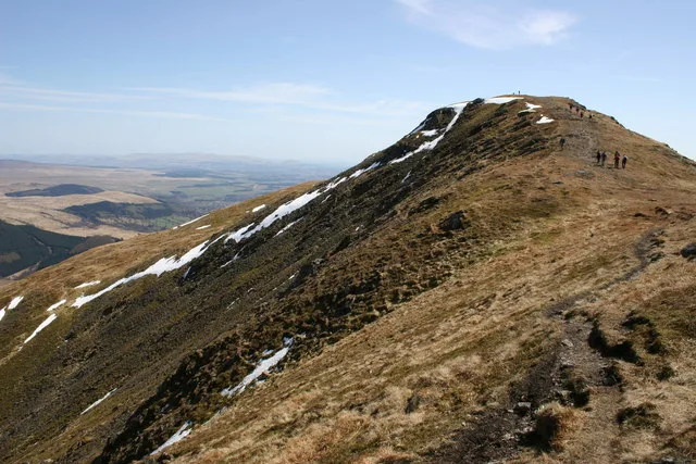
Ben Ledi — 879m high mountain in Stirling, Scotland, UK.

Wikimedia Commons contributors — see linked file page for photographer and licence licence

Plan your visit
- Typical visit
- 1 h–2 h
- Free entry
- Dog-friendly
About
Ben Ledi is a named natural landmark in the United Kingdom. Wikidata describes it as: "879m high mountain in Stirling, Scotland, UK". Coordinates: 56.2587°, -4.3224°.
Photo gallery
From the Wikipedia article
Ben Ledi (Beinn Leitir in Scottish Gaelic) is a mountain in Stirling, Scotland. It is 878.6 metres (2,883 feet) high, and is therefore classified as a Corbett. It lies about six kilometres (four miles) northwest of Callander, near the village of Kilmahog. It is situated in the Trossachs, an area often regarded as having some of the most romantic scenery in the Highlands.
Excerpt from Wikipedia under CC BY-SA 4.0. See the source article linked in Sources below.
Background
History
Ben Ledi is particularly well known through Walter Scott's poem Lady of the Lake. Supposedly in ancient times, Beltane rites were observed on the summit. There are what is thought to be possible references to these Beltane rights in some of the Gaelic names on the mountain: Creag Ghorn; "Rock of Embers" and Creag Loisgte; "Burned Rock". In 1791 the Rev Doctor James Robertson, being minister of the parish at the time, was required to write a description of the parish for the First Statistical Account of Scotland. In his report he mistakenly (due to the similarity to le dia) took the name Ben Ledi to mean "hill of god" which suited the purposes of the kirk of the day. The name is in fact a…
Visiting
The eastern slopes of Ben Ledi are owned by Forestry and Land Scotland, and form part of the Queen Elizabeth Forest Park. A constructed path leads from a car park on the A84 road just south of Loch Lubnaig to a fence at about 270 m above sea level, where a rough track continues to the summit via the south shoulder, a distance of just over 3 km. An alternative route following Stank Glen leaves the shores of Loch Lubnaig about 1.5 km north of the start of the main route, reaching the summit ridge near Lochan nan Corp. The two routes may be combined to give a circular walk of about 9 km. A short distance down to the south-east of the summit trig point, an iron cross commemorates Sergeant Harry…
Sourced from Wikipedia under CC BY-SA 4.0.
- Coordinates
- 56.2587, -4.3224
- Address
- Stirling, Scotland
Sources
- wikidata: Q816543 (CC0)
- wikipedia: Ben Ledi (CC BY-SA 4.0)
- commons: Ben Ledi - North Ridge - geograph.org.uk - 162247.jpg (CC BY-SA 4.0)
Other places nearby
Ben Ledi
Mountains & hills · 0.0 km

Sgt. Harry Lawrie Cross
Memorials & monuments · 0.1 km

Stuc Odhar
Mountains & hills · 1.6 km

Bioran na Circe
Mountains & hills · 2.0 km

Am Fireach
Mountains & hills · 2.7 km
Ardnandave
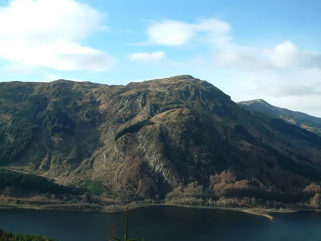
Mountains & hills · 2.7 km

Ardnandave Hill
Mountains & hills · 2.8 km

Stùc Dhubh
Mountains & hills · 2.8 km

Falls of Leny
Other places · 3.1 km
.jpg?width=1200)
Falls of Leny
Waterfalls · 3.1 km

Lendrick Hill
Waterfalls · 3.2 km

Meall Garbh
Mountains & hills · 3.3 km
Nearby
📷 5📷 3Memorials & monuments · Central Scotland
Sgt. Harry Lawrie Cross
Sgt. Harry Lawrie Cross — a memorial in scotland-central, United Kingdom.
📷 3Mountains & hills · Central Scotland
Stuc Odhar
Stuc Odhar — a mountain in scotland-central, United Kingdom.
📷 3Mountains & hills · Central Scotland
Bioran na Circe
Bioran na Circe — a mountain in scotland-central, United Kingdom.
📷 5Mountains & hills · Central Scotland
Am Fireach
Am Fireach — a mountain in scotland-central, United Kingdom.
📷 3Where to eat & stay near Ben Ledi
Places to stay
 📷 5
📷 5Campsites · Central Scotland
Falls of Leny Campsite
Falls of Leny Campsite — a campsite in scotland central.
 📷 5
📷 5 📷 5
📷 5Hostels · Central Scotland
Trossachs Tryst
Trossachs Tryst — a hostel in scotland central.
 📷 5
📷 5Campsites · Central Scotland
Loch Achray Campsite
Loch Achray Campsite — a campsite in scotland central.
 📷 7
📷 7 📷 5
📷 5Campsites · Central Scotland
Loch Achray South camping permit area March-September
Loch Achray South camping permit area March-September — a campsite in scotland central.
More natural landmarks in this region
 📷 4
📷 4Natural landmarks · Central Scotland
Blackadder Water
Blackadder Water in England North East, United Kingdom.
 📷 3
📷 3Natural landmarks · Central Scotland
A6105 road
A6105 road in England North East, United Kingdom.
 📷 3
📷 3 📷 3
📷 3Frequently asked questions
- Where is Ben Ledi?
- Ben Ledi is in central Scotland, United Kingdom.
- What is Ben Ledi?
- Ben Ledi — 879m high mountain in Stirling, Scotland, UK.
- How do I get to Ben Ledi?
- The nearest town is Brig o' Turk. Its coordinates are 56.2587°, -4.3224°.
- Is Ben Ledi free to visit?
- Yes, Ben Ledi is free to enter.