Mountains & hills · Scottish Highlands
Beinn Uamha
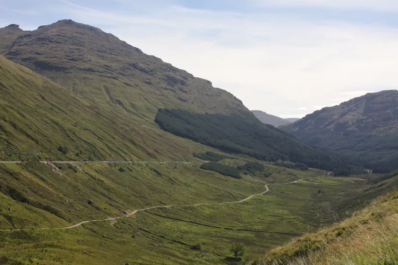
Beinn Uamha — mountain in scotland highlands. Elevation: 596 m.

ian shiell — CC BY-SA 2.0 via Wikimedia Commons licence
Plan your visit
- Typical visit
- 3 h–8 h
- Best time of year
- Late spring – early autumn (May–Oct)
About
Beinn Uamha is a mountain located in scotland highlands. Elevation: 596 m. A named British peak recorded in OpenStreetMap. Peaks are typically named on Ordnance Survey 1:50k mapping.
Photo gallery
Place summary
Beinn Uamha is a mountain located in the Scottish Highlands. It is characterised by its rugged terrain and scenic views typical of the region. The mountain offers opportunities for walking and climbing, attracting outdoor enthusiasts. Visitors can expect a remote and tranquil setting amidst the dramatic landscapes of the Highlands.
AI-generated from the structured facts on this page (operator, designation, listing, era). Not a substitute for visiting.
- Coordinates
- 56.2273, -4.6044
Sources
- osm: n1307242366 (ODbL)
Other places nearby
Loading nearby places…
Nearby
 📷 5
📷 5Mountains & hills · Scottish Highlands
Beinn Uamha
Beinn Uamha — a hill or mountain in scotland highlands.
 📷 5
📷 5Reservoirs & lochs · Scottish Highlands
Loch Arklet Reservoir
Loch Arklet Reservoir — a reservoir in scotland highlands.
 📷 5
📷 5Mountains & hills · Scottish Highlands
Stuc Gille Chonnuill
Stuc Gille Chonnuill — a hill or mountain in scotland highlands.
 📷 5
📷 5Mountains & hills · Scottish Highlands
Maol a' Chapuill
Maol a' Chapuill — a hill or mountain in scotland highlands.
 📷 3
📷 3Reservoirs & lochs · Scottish Highlands
Loch Arklet
Loch Arklet — reservoir in Stirling, Scotland, UK, outflows west via Arklet Water to Loch Ness, and east via a tunnel to Loch Katrine.
 Flagship📷 5
National parks · Scottish Highlands
Loch Lomond and The Trossachs National Park
Loch Lomond and The Trossachs National Park is a National park in Scotland.
Where to eat & stay near Beinn Uamha
Places to stay
 📷 5
📷 5Hotels · Scottish Highlands
Inversnaid Bunkhouse
Inversnaid Bunkhouse — a hotel in scotland highlands.
 📷 5
📷 5Campsites · Scottish Highlands
Loch Chon Campsite
Loch Chon Campsite — a campsite in scotland highlands.
 📷 5
📷 5Hotels · Scottish Highlands
Inversnaid Hotel
Inversnaid Hotel — a hotel in scotland highlands.
 📷 5
📷 5Campsites · Scottish Highlands
Tarbet isle camping permit area March-September
Tarbet isle camping permit area March-September — a campsite in scotland highlands.
 📷 5
📷 5Campsites · Scottish Highlands
Inveruglas camping permit area March-September
Inveruglas camping permit area March-September — a campsite in scotland highlands.
 📷 5
📷 5Hotels · Scottish Highlands
Tarbet Hotel
Tarbet Hotel — a hotel in scotland highlands.

More mountains in this region
 📷 3
📷 3Mountains & hills · Scottish Highlands
A' Bhuidheanach Bheag
A' Bhuidheanach Bheag — Named summit at 936 m.
 📷 3
📷 3Mountains & hills · Scottish Highlands
A' Chailleach
A' Chailleach — Named summit at 997 m.
 📷 3
📷 3Mountains & hills · Scottish Highlands
A' Chailleach
A' Chailleach — Named summit at 930 m.
 📷 3
📷 3Mountains & hills · Scottish Highlands
A' Chaoirnich
A' Chaoirnich — Named summit at 875 m.
Frequently asked questions
- Where is Beinn Uamha?
- Beinn Uamha is in the Scottish Highlands, United Kingdom.
- What is Beinn Uamha?
- Beinn Uamha — mountain in scotland highlands. Elevation: 596 m.
- How do I get to Beinn Uamha?
- Its coordinates are 56.2273°, -4.6044°.