
Natural landmarks · Scottish Highlands
Beinn Fhada
Also known as: Beinn Fhada 1032m, A' Bheinn Fhada
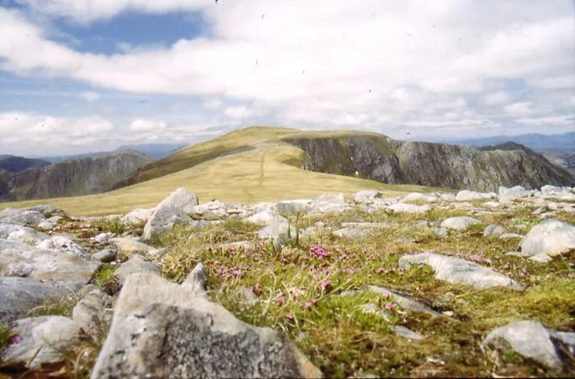
Beinn Fhada — 1032m high mountain in Highland, Scotland, UK.

Wikimedia Commons contributors — see linked file page for photographer and licence licence

Plan your visit
- Typical visit
- 1 h–2 h
- Free entry
- Dog-friendly
About
Beinn Fhada is a named natural landmark in the United Kingdom. Part of Kintail. Wikidata describes it as: "1032m high mountain in Highland, Scotland, UK". Coordinates: 57.2210°, -5.2835°.
Photo gallery
Official information
Beinn Fhada is a mountain located in the Kintail region of Scotland, featuring a vast summit plateau and steep, rocky sides. Visitors can enjoy stunning views from the summit and explore various routes, including scrambles and long ridges.
From the Wikipedia article
Beinn Fhada (Scottish Gaelic for 'long mountain') or Ben Attow is a mountain in the Scottish Highlands. The finest route up Beinn Fhada is from Morvich to the north-west. There is a direct line up a grassy, and rather boggy, slope from the east side of the River Croe. This leads eventually to a craggy and undulating ridge, which begins in a southerly direction over Sgurr a' Choire Ghairbh and then turns east across the wider expanse of the Plaide Mhòr to the summit. There is one short tricky section of downward scrambling on this ridge. An easy line of descent can be found, north-westwards from the summit, into Gleann Choinneachain. Total distance from Morvich is about 7 km, with around 1100 metres of ascent, including undulations. Beinn Fhada has been dismissed by some guide writers as boring. It has two remarkable features: the Plaide Mor is the largest extent of ancient (preglacial) land surface to survive in the western Highlands, and is of Cairngorm character. Secondly, its SW slopes into Gleann Lichd are seamed for 3 km with trenches reaching 10m high and 800m long, a slope deformation that is the largest 'rock slope failure' in the Highlands.
Excerpt from Wikipedia under CC BY-SA 4.0. See the source article linked in Sources below.
- Coordinates
- 57.2210, -5.2835
- Address
- Highland, Scotland
- Official site
- www.walkhighlands.co.uk
Sources
- wikidata: Q3403774 (CC0)
- wikipedia: Beinn Fhada (CC BY-SA 4.0)
- commons: Beinn Attow.jpg (CC BY-SA 4.0)
Other places nearby
Beinn Fhada
Mountains & hills · 0.0 km

Loch a’ Bhealaich
Lakes · 1.7 km

Sgurr a' Dubh Doire
Mountains & hills · 1.7 km

Meall an Fhuarain Mhoir
Mountains & hills · 1.9 km

Meall a' Bhealaich
Mountains & hills · 1.9 km

Meall an Fhuarain Mhòir
Mountains & hills · 1.9 km

Grannda Falls
Waterfalls · 2.1 km

A' Ghlas-bheinn South Top
Mountains & hills · 2.8 km

Faradh Nighean Fhearchair
Mountains & hills · 2.8 km

Sgùrr a' Choire Ghairbh
Mountains & hills · 2.9 km

Sgùrr Gaorsaic
Mountains & hills · 3.0 km

Sgurr Gaorsaic
Mountains & hills · 3.1 km
Nearby
📷 3Mountains & hills · Scottish Highlands
Beinn Fhada
Beinn Fhada — Named summit at 1032 m.
📷 5📷 3Mountains & hills · Scottish Highlands
Sgurr a' Dubh Doire
Sgurr a' Dubh Doire — a mountain in scotland-highlands, United Kingdom.
📷 5Mountains & hills · Scottish Highlands
Meall an Fhuarain Mhoir
Meall an Fhuarain Mhoir — a hill or mountain in scotland highlands.
📷 3Mountains & hills · Scottish Highlands
Meall a' Bhealaich
Meall a' Bhealaich — a mountain in scotland-highlands, United Kingdom.
📷 3Mountains & hills · Scottish Highlands
Meall an Fhuarain Mhòir
Meall an Fhuarain Mhòir — a mountain in scotland-highlands, United Kingdom.
Where to eat & stay near Beinn Fhada
Places to stay
 📷 5
📷 5Hostels · Scottish Highlands
Kintail Outdoor Centre
Kintail Outdoor Centre — a hostel in scotland highlands.
 📷 5
📷 5Campsites · Scottish Highlands
Morvich Club Campsite
Morvich Club Campsite — a campsite in scotland highlands.
 📷 5
📷 5Hostels · Scottish Highlands
Glen Affric SYHA
Glen Affric SYHA — a hostel in scotland highlands.
 📷 5
📷 5Campsites · Scottish Highlands
Glenshiel Campsite
Glenshiel Campsite — a campsite in scotland highlands.
 📷 5
📷 5B&Bs · Scottish Highlands
Shiel House
Shiel House — a bed-and-breakfast in scotland highlands.
 📷 7
📷 7Hotels · Scottish Highlands
Cluanie Inn
Cluanie Inn — a hotel in scotland highlands.
More natural landmarks in this region
 Flagship📷 3
Natural landmarks · Scottish Highlands
Dunalastair Water
Dunalastair Water — lake in Perth and Kinross, Scotland, UK, on the River Tummel.
 Flagship📷 3
Natural landmarks · Scottish Highlands
Loch Arkaig
Loch Arkaig — lake in Highland, Scotland, UK, outflows east to River Arkaig.
 Flagship📷 3
Natural landmarks · Scottish Highlands
Loch Assynt
Loch Assynt — lake in Highland, Scotland, UK, outflows to the River Inver and Loch na Garbh Uidhe.
 Flagship📷 5
Natural landmarks · Scottish Highlands
Loch Eilt
Loch Eilt — lake in Highland, Scotland, UK, outflows west to River Ailort.
Frequently asked questions
- Where is Beinn Fhada?
- Beinn Fhada is in the Scottish Highlands, United Kingdom.
- What is Beinn Fhada?
- Beinn Fhada — 1032m high mountain in Highland, Scotland, UK.
- How do I get to Beinn Fhada?
- Its coordinates are 57.2210°, -5.2835°.
- Is Beinn Fhada free to visit?
- Yes, Beinn Fhada is free to enter.