Mountains & hills · Scottish Highlands
Beinn Fhada
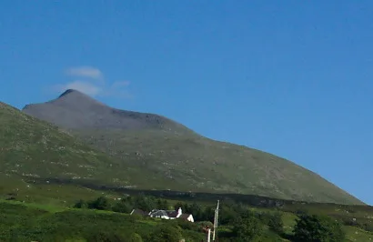
Beinn Fhada — mountain in scotland highlands. Elevation: 702 m.

Rude Health — CC BY-SA 2.0 via Wikimedia Commons licence
Plan your visit
- Typical visit
- 3 h–8 h
- Best time of year
- Late spring – early autumn (May–Oct)
About
Beinn Fhada is a mountain located in scotland highlands. Elevation: 702 m. A named British peak recorded in OpenStreetMap. Peaks are typically named on Ordnance Survey 1:50k mapping.
Photo gallery
Place summary
Beinn Fhada is a mountain located in the Scottish Highlands. It is characterised by its rugged terrain and scenic vistas typical of the region. Popular among hikers and climbers, it offers a variety of routes for outdoor enthusiasts. The mountain's elevation and landscape provide a striking backdrop for those exploring the Highlands.
AI-generated from the structured facts on this page (operator, designation, listing, era). Not a substitute for visiting.
- Coordinates
- 56.4421, -5.9922
Sources
- osm: n1741382905 (ODbL)
- wikidata: Q13125850 (CC0)
Other places nearby
Loading nearby places…
Nearby
📷 5Mountains & hills · Scottish Highlands
Beinn Fhada
Beinn Fhada — a hill or mountain in scotland highlands.
 📷 5
📷 5Mountains & hills · Scottish Highlands
An Cruachan
An Cruachan — mountain in scotland highlands. Elevation: 581 m.
 Flagship📷 5
Islands · Scottish Highlands
Isle of Mull
Isle of Mull — second-largest Inner Hebrides island (after Skye) off the west coast of Scotland.
 📷 5
📷 5Mountains & hills · Scottish Highlands
Beinn nan Gabhar
Beinn nan Gabhar — a hill or mountain in scotland highlands.
📷 5Mountains & hills · Scottish Highlands
Beinn nan Gabhar
Beinn nan Gabhar — mountain in scotland highlands. Elevation: 572 m.
 📷 5
📷 5Mountains & hills · Scottish Highlands
A' Chioch
A' Chioch — mountain in scotland highlands. Elevation: 867 m.
Where to eat & stay near Beinn Fhada
Places to stay
 📷 5
📷 5Campsites · Scottish Highlands
Killiechronan Campsite
Killiechronan Campsite — a campsite in scotland highlands.
 📷 5
📷 5Campsites · Scottish Highlands
Port nan Gael
Port nan Gael — a campsite in scotland highlands.
 📷 5
📷 5Campsites · Scottish Highlands
Salen Bay Campsite
Salen Bay Campsite — a campsite in scotland highlands.
 📷 5
📷 5Hostels · Scottish Highlands
Ulva Hostel
Ulva Hostel — a hostel in scotland highlands.
 📷 5
📷 5Hostels · Scottish Highlands
Highland Basecamp
Highland Basecamp — a hostel in scotland highlands.
 📷 5
📷 5Hostels · Scottish Highlands
Craignure Bunkhouse
Craignure Bunkhouse — a hostel in scotland highlands.

More mountains in this region
 📷 3
📷 3Mountains & hills · Scottish Highlands
A' Bhuidheanach Bheag
A' Bhuidheanach Bheag — Named summit at 936 m.
 📷 3
📷 3Mountains & hills · Scottish Highlands
A' Chailleach
A' Chailleach — Named summit at 997 m.
 📷 3
📷 3Mountains & hills · Scottish Highlands
A' Chailleach
A' Chailleach — Named summit at 930 m.
 📷 3
📷 3Mountains & hills · Scottish Highlands
A' Chaoirnich
A' Chaoirnich — Named summit at 875 m.
Frequently asked questions
- Where is Beinn Fhada?
- Beinn Fhada is in the Scottish Highlands, United Kingdom.
- What is Beinn Fhada?
- Beinn Fhada — mountain in scotland highlands. Elevation: 702 m.
- How do I get to Beinn Fhada?
- Its coordinates are 56.4421°, -5.9922°.