
Natural landmarks · Scottish Highlands
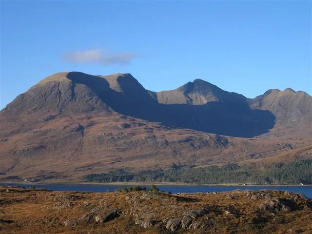
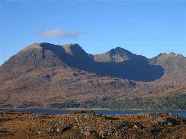
Beinn Alligin
Also known as: Beinn Áilleagan, Beinn Àilleagain
Beinn Alligin — mountain in Highland, Scotland, UK.

Wikimedia Commons contributors — see linked file page for photographer and licence licence

Plan your visit
- Typical visit
- 1 h–2 h
- Free entry
- Dog-friendly
About
Beinn Alligin is a named natural landmark in the United Kingdom. Wikidata describes it as: "mountain in Highland, Scotland, UK". Coordinates: 57.5908°, -5.5728°.
Photo gallery
Official information
Beinn Alligin is a mountain located in the Torridon region of Scotland, known for its stunning ridges and scenic views. Visitors can enjoy hiking routes that include the Horns of Alligin and the summits of Sgurr Mor and Tom na Gruagaich.
From the Wikipedia article
Beinn Alligin (Scottish Gaelic: Beinn Àilleagan) is one of the classic mountains of the Torridon region of Scotland, lying to the north of Loch Torridon, in the Highlands. The name Beinn Alligin is from the Scottish Gaelic, meaning Jewelled Hill. The mountain has two peaks of Munro status: Tom na Gruagaich (922 m or 3,025 ft) to the south, and Sgùrr Mòr at 986 metres (3,235 ft) to the north. One of the most prominent features of Beinn Alligin is a great cleft known as Eag Dhubh na h-Eigheachd (black gash of the wailing) or Leum na Caillich, which cuts into the ridge south of the summit. It is the scar of the most spectacular rockslide or rock avalanche in Britain, which runs out into the corrie of Toll a' Mhadaidh Mor. It occurred around 3750 years ago and is around 3.5 million cubic metres in volume. According to local folklore shepherds on the mountain would hear cries from the gash; those who investigated the source of these cries would inevitably fall to their deaths. Beinn Alligin lies on the National Trust for Scotland's Torridon Estate, which has been owned by the charity since 1967, and forms part of both a Site of Special Scientific Interest (SSSI) and a Special Area of Conservation (SAC).
Excerpt from Wikipedia under CC BY-SA 4.0. See the source article linked in Sources below.
- Coordinates
- 57.5908, -5.5728
- Address
- Torridon, Scotland
- Official site
- www.hill-bagging.co.uk
Sources
- wikidata: Q3356612 (CC0)
- wikipedia: Beinn Alligin (CC BY-SA 4.0)
- commons: Beinn Alligin in Autumn Sunshine - geograph.org.uk - 144409.jpg (CC BY-SA 4.0)
Other places nearby
Sgùrr Mòr
Mountains & hills · 0.0 km

Sgurr Mhor
Mountains & hills · 0.0 km

Beinn Alligin - Sgurr Mor
Mountains & hills · 0.0 km

Na Rathanan
Mountains & hills · 0.7 km

Beinn Alligin - Tom na Gruagaich
Mountains & hills · 1.3 km
Tom na Gruagaich
Mountains & hills · 1.3 km

Creag a' Chinn Duibh
Mountains & hills · 1.7 km

Creag a' Chinn Duibh
Mountains & hills · 1.7 km
Meall na h-Odhar-Aghaidh
Mountains & hills · 2.1 km

Stuc Loch na Cabhaig
Mountains & hills · 2.6 km

An Ruadh-mheallan
Mountains & hills · 2.9 km

Loch a’ Bhealaich
Lakes · 2.9 km
Nearby
📷 3Mountains & hills · Scottish Highlands
Sgùrr Mòr
Sgùrr Mòr — Named summit at 986 m.
📷 3Mountains & hills · Scottish Highlands
Sgurr Mhor
Sgurr Mhor — a mountain in scotland-highlands, United Kingdom, 986 m.
📷 5Mountains & hills · Scottish Highlands
Beinn Alligin - Sgurr Mor
Beinn Alligin - Sgurr Mor — a hill or mountain in scotland highlands.
📷 3Mountains & hills · Scottish Highlands
Na Rathanan
Na Rathanan — a mountain in scotland-highlands, United Kingdom.
📷 5Mountains & hills · Scottish Highlands
Beinn Alligin - Tom na Gruagaich
Beinn Alligin - Tom na Gruagaich — a hill or mountain in scotland highlands.
📷 3Mountains & hills · Scottish Highlands
Tom na Gruagaich
Tom na Gruagaich — Named summit at 922 m.
Where to eat & stay near Beinn Alligin
Places to stay
 📷 5
📷 5Hostels · Scottish Highlands
Torridon Youth Hostel
Torridon Youth Hostel — a hostel in scotland highlands.
 📷 5
📷 5Campsites · Scottish Highlands
Torridon Camp Site
Torridon Camp Site — a campsite in scotland highlands.
 📷 5
📷 5Campsites · Scottish Highlands
Shieldaig Camping and Cabins
Shieldaig Camping and Cabins — a campsite in scotland highlands.
 📷 5
📷 5Campsites · Scottish Highlands
Beinn Eighe Campsite
Beinn Eighe Campsite — a campsite in scotland highlands.
 📷 5
📷 5Caravan parks · Scottish Highlands
Kinlochewe Caravan Club Site
Kinlochewe Caravan Club Site — a caravan park in scotland highlands.
 📷 5
📷 5Hostels · Scottish Highlands
Kinlochewe Bunkhouse
Kinlochewe Bunkhouse — a hostel in scotland highlands.
More natural landmarks in this region
 Flagship📷 3
Natural landmarks · Scottish Highlands
Dunalastair Water
Dunalastair Water — lake in Perth and Kinross, Scotland, UK, on the River Tummel.
 Flagship📷 3
Natural landmarks · Scottish Highlands
Loch Arkaig
Loch Arkaig — lake in Highland, Scotland, UK, outflows east to River Arkaig.
 Flagship📷 3
Natural landmarks · Scottish Highlands
Loch Assynt
Loch Assynt — lake in Highland, Scotland, UK, outflows to the River Inver and Loch na Garbh Uidhe.
 Flagship📷 5
Natural landmarks · Scottish Highlands
Loch Eilt
Loch Eilt — lake in Highland, Scotland, UK, outflows west to River Ailort.
Frequently asked questions
- Where is Beinn Alligin?
- Beinn Alligin is in the Scottish Highlands, United Kingdom.
- What is Beinn Alligin?
- Beinn Alligin — mountain in Highland, Scotland, UK.
- How do I get to Beinn Alligin?
- Its coordinates are 57.5908°, -5.5728°.
- Is Beinn Alligin free to visit?
- Yes, Beinn Alligin is free to enter.