
Mountains & hills · Central Scotland
Beinn a' Choin
In or near Tarbet.
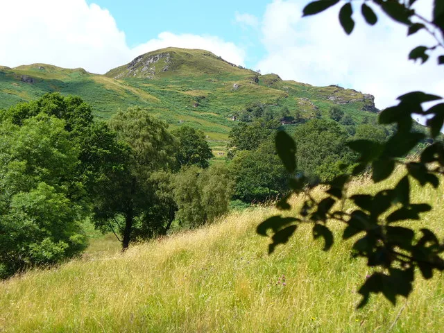
Beinn a' Choin — Named summit at 770 m.

Wikimedia Commons contributors — see linked file page for photographer and licence licence

Plan your visit
- Typical visit
- 3 h–8 h
- Best time of year
- Late spring – early autumn (May–Oct)
- Nearest railway station
- Ardlui · 4.6 km
- Free entry
- Dog-friendly
About
Beinn a' Choin is a named summit in the United Kingdom. Wikidata describes it as: "Named summit at 770 m.". Coordinates: 56.2805°, -4.6583°.
Photo gallery
Official information
Beinn a' Choin is a mountain located near Inversnaid, known for its rugged terrain and scenic views. Visitors can hike various routes to the summit, often starting from the RSPB car park, and experience the natural beauty of the surrounding landscape.
From the Wikipedia article
Beinn a' Choin (769 m) is a mountain in the Grampian Mountains of Scotland. It lies on the border of the Stirling region and Argyll at the northern end of Loch Lomond. A rugged and wild mountain of rocks and moorland lying north of Ben Lomond, it usually climbed from the small settlement of Inversnaid.
Excerpt from Wikipedia under CC BY-SA 4.0. See the source article linked in Sources below.
- Coordinates
- 56.2805, -4.6583
- Address
- Stirling / Argyll and Bute, Scotland
- Nearest railway station
- Ardlui — 4.6 km
- Official site
- www.hill-bagging.co.uk
Sources
- osm: n1276917214 (ODbL)
- wikipedia: Beinn a' Chòin (CC BY-SA 4.0)
- commons: On Beinn a' Choin - geograph.org.uk - 29730.jpg (CC BY-SA 4.0)
Other places nearby

Maol an Fhithich
Mountains & hills · 1.1 km

Glen Gyle
Gorges · 1.6 km

Stob nan Eighrach
Mountains & hills · 2.0 km

Stob an Fhainne
Mountains & hills · 2.0 km

Maol Mor
Mountains & hills · 2.1 km

Maol Mòr
Mountains & hills · 2.1 km

Island I Vow
Islands · 2.4 km

Island I Vow Castle
Castles · 2.4 km

Ben Ducteach
Mountains & hills · 2.5 km
Beinn Ducteach
Mountains & hills · 2.6 km

Sithean a` Chatha
Mountains & hills · 3.3 km
Meall Mòr
Mountains & hills · 3.6 km
Nearby
📷 5Mountains & hills · Central Scotland
Maol an Fhithich
Maol an Fhithich — a mountain in scotland-highlands, United Kingdom.
📷 5📷 3Mountains & hills · Central Scotland
Stob nan Eighrach
Stob nan Eighrach — a mountain in scotland-highlands, United Kingdom.
📷 3Mountains & hills · Central Scotland
Stob an Fhainne
Stob an Fhainne — a mountain in scotland-highlands, United Kingdom.
📷 5📷 3Mountains & hills · Central Scotland
Maol Mòr
Maol Mòr — a mountain in scotland-highlands, United Kingdom, 693 m.
Where to eat & stay near Beinn a' Choin
Places to stay
 📷 7
📷 7Hotels · Central Scotland
Inversnaid Bunkhouse
Inversnaid Bunkhouse — a hotel in scotland highlands.
 📷 5
📷 5Campsites · Central Scotland
Inveruglas camping permit area March-September
Inveruglas camping permit area March-September — a campsite in scotland highlands.
 📷 7
📷 7 📷 5
📷 5Campsites · Central Scotland
Ardlui Holiday Home Park
Ardlui Holiday Home Park — a campsite in scotland highlands.
 📷 5
📷 5Campsites · Central Scotland
Beinglas Farm
Beinglas Farm — a campsite in scotland highlands.
 📷 5
📷 5Campsites · Central Scotland
Tarbet isle camping permit area March-September
Tarbet isle camping permit area March-September — a campsite in scotland highlands.
Places to eat & drink
 📷 5
📷 5Historic pubs · Central Scotland
The Drovers Inn
The Drovers Inn — Historic pub — listed building or notable heritage status.
More mountains in this region
 📷 3
📷 3 📷 3
📷 3 📷 3
📷 3Mountains & hills · Central Scotland
An Caisteal
An Caisteal — Named summit at 995 m.
 📷 5
📷 5Frequently asked questions
- Where is Beinn a' Choin?
- Beinn a' Choin is in central Scotland, United Kingdom.
- What is Beinn a' Choin?
- Beinn a' Choin — Named summit at 770 m.
- How do I get to Beinn a' Choin?
- The nearest railway station is Ardlui, about 4.6 km away. The nearest town is Tarbet. Its coordinates are 56.2805°, -4.6583°.
- Is Beinn a' Choin free to visit?
- Yes, Beinn a' Choin is free to enter.
- How do I get to Beinn a' Choin?
- The nearest railway station is Ardlui, about 4.6 km away.