
Mountains & hills · Scottish Highlands
Beinn a' Chlaidheimh
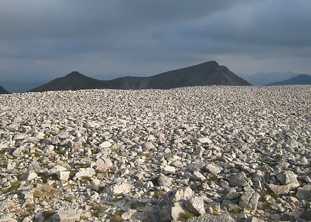
Beinn a' Chlaidheimh — Named summit at 913.9 m.

Wikimedia Commons contributors — see linked file page for photographer and licence licence

Plan your visit
- Typical visit
- 3 h–8 h
- Best time of year
- Late spring – early autumn (May–Oct)
- Free entry
- Dog-friendly
About
Beinn a' Chlaidheimh is a named summit in the United Kingdom. Wikidata describes it as: "Named summit at 913.9 m.". Coordinates: 57.7459°, -5.2591°.
Photo gallery
Official information
Beinn a' Chlaidheimh is a mountain located in the Fisherfield Forest, known for its stunning views and challenging hikes. It is part of the Fisherfield Six, a popular circuit among hikers and climbers. Visitors can enjoy various routes leading to the summit, which offers panoramic vistas of the surrounding landscape.
From the Wikipedia article
Beinn a' Chlaidheimh (Scottish Gaelic: "Hill of the Sword", 914 m) is a remote mountain in the Northwest Highlands, Scotland. It lies in the wild Dundonnell and Fisherfield Forest in Wester Ross. A steep and distinctive shaped peak, it is often climbed as part of the "Fisherfield Six", in conjunction with five nearby Munros. Beinn a' Chlaidheimh was listed as a Munro itself until 2012, however it was found to come up just 44 cm short of the required 914.40 m height required for a Munro, and was subsequently downgraded to Corbett status.
Excerpt from Wikipedia under CC BY-SA 4.0. See the source article linked in Sources below.
- Coordinates
- 57.7459, -5.2591
- Address
- Wester Ross, Scotland
- Official site
- www.hill-bagging.co.uk
Sources
- osm: n266818797 (ODbL)
- wikipedia: Beinn a' Chlaidheimh (CC BY-SA 4.0)
- commons: Hillside and Beinn a'Chlaidheimh - geograph.org.uk - 1310175.jpg (CC BY-SA 4.0)
Other places nearby

Gleann na Muice
Gorges · 1.5 km

Loch an Nid
Lakes · 2.1 km

Strath na Sheallag
Gorges · 2.4 km

Creag Mhor a' Bhinnein
Mountains & hills · 2.6 km
Sgùrr Bàn
Mountains & hills · 3.1 km

Sgurr Ban
Mountains & hills · 3.1 km

Beinn Dearg Mor East Top
Mountains & hills · 3.1 km

Beinn Dearg Mòr East Top
Mountains & hills · 3.4 km
Ruadh-stac Beag
Mountains & hills · 3.4 km

Eas Dhomhnuill Dhuibh
Natural landmarks · 3.5 km
Eas Bàn
Natural landmarks · 3.5 km

Ruadh Stac Beag South Top
Mountains & hills · 3.5 km
Nearby
📷 5📷 5📷 5📷 5Mountains & hills · Scottish Highlands
Creag Mhor a' Bhinnein
Creag Mhor a' Bhinnein — a hill or mountain in scotland highlands.
📷 3📷 5Mountains & hills · Scottish Highlands
Sgurr Ban
Sgurr Ban — a hill or mountain in scotland highlands.
Where to eat & stay near Beinn a' Chlaidheimh
Places to stay
 📷 5
📷 5Hostels · Scottish Highlands
Sail Mhor Croft Hostel
Sail Mhor Croft Hostel — a hostel in scotland highlands.
 📷 5
📷 5Hostels · Scottish Highlands
Forest Way Bunkhouse
Forest Way Bunkhouse — a hostel in scotland highlands.
 📷 5
📷 5Campsites · Scottish Highlands
Badrallach Campsite
Badrallach Campsite — a campsite in scotland highlands.
 📷 5
📷 5Campsites · Scottish Highlands
Northern Lights Camping & Caravan Park
Northern Lights Camping & Caravan Park — a campsite in scotland highlands.
 📷 5
📷 5Campsites · Scottish Highlands
Beinn Eighe Campsite
Beinn Eighe Campsite — a campsite in scotland highlands.
 📷 5
📷 5Hostels · Scottish Highlands
Kinlochewe Bunkhouse
Kinlochewe Bunkhouse — a hostel in scotland highlands.
More mountains in this region
 📷 3
📷 3Mountains & hills · Scottish Highlands
A' Bhuidheanach Bheag
A' Bhuidheanach Bheag — Named summit at 936 m.
 📷 3
📷 3Mountains & hills · Scottish Highlands
A' Chailleach
A' Chailleach — Named summit at 997 m.
 📷 3
📷 3Mountains & hills · Scottish Highlands
A' Chailleach
A' Chailleach — Named summit at 930 m.
 📷 3
📷 3Frequently asked questions
- Where is Beinn a' Chlaidheimh?
- Beinn a' Chlaidheimh is in the Scottish Highlands, United Kingdom.
- What is Beinn a' Chlaidheimh?
- Beinn a' Chlaidheimh — Named summit at 913.9 m.
- How do I get to Beinn a' Chlaidheimh?
- Its coordinates are 57.7459°, -5.2591°.
- Is Beinn a' Chlaidheimh free to visit?
- Yes, Beinn a' Chlaidheimh is free to enter.