
Viewpoints · Scottish Highlands
Bealach na Bà
Also known as: Bealach na Bá
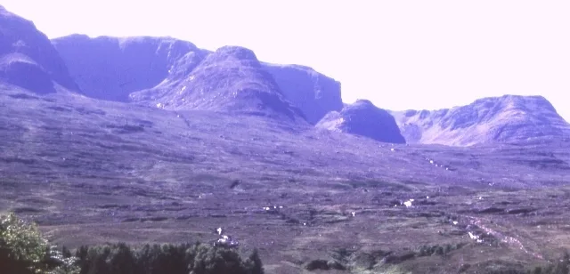
Bealach na Bà — Named viewpoint at 626 m elevation.

Alpin Stewart — CC BY-SA 2.0 via Wikimedia Commons licence

Plan your visit
- Typical visit
- 20 min–45 min
- Best time of year
- Clear days year-round
- Nearest railway station
- Plockton · 9.8 km
- Free entry
- Dog-friendly
Getting there & planning your visit
To visit Bealach na Bà, the nearest railway station is Plockton, located 9.8 km away. Entry is free. There are no specific accessibility details provided.
About
Bealach na Bà is a named viewpoint in the United Kingdom. Wikidata describes it as: "Named viewpoint at 626 m elevation.". Coordinates: 57.4187°, -5.7088°.
Photo gallery
See it from the streetimagery from 2023
Imagery © Mapillary contributors, CC BY-SA 4.0
From the Wikipedia article
Bealach na Bà (pronounced [bjal̪ˠəx nə baː]) is a winding pass through the mountains of the Applecross peninsula, in Wester Ross in the Scottish Highlands. It is traversed by a single track road, which passes through several corries. The road links the village of Applecross on the west coast with Loch Kishorn to the east. The eastern end of the road is the junction with the A896 road at Tornapress, north of the village of Kishorn. The road over the historic mountain pass was built in 1822 and is engineered similarly to roads through the great mountain passes in the Alps, with very tight hairpin bends that switch back and forth up the hillside and gradients that approach 20%. It has the greatest ascent of any road climb in the United Kingdom, rising from sea level at Applecross to 630 m (2,070 ft) in about 6 km (3.7 mi), and is the third highest mountain pass in Scotland. The name is Scottish Gaelic for Pass of the Cattle, as it was historically used as a drovers' road, driving cattle to markets in Muir of Ord, Falkirk and even as far as London. The bealach is considered unsuitable for learner drivers and very large vehicles, and the route is often impassable in winter. According to Country Life, "the single-track, historic drovers' lane travels up, down and around hairpins through the mountains of the remote Applecross peninsula as if they were the Alps and, at Bealach na Bà ('pass of the cattle'), features the steepest ascent of any road in the UK".
Excerpt from Wikipedia under CC BY-SA 4.0. See the source article linked in Sources below.
Background
History
The route existed as a simple track since the Irish monk St Maelrubha founded a monastery at Applecross. Construction of the road started in May 1818, but the first contactor only lasted three months. John Reid & Son from Edinburgh finally completed the construction in September 1822. The road cost around £4000, or about £0.5m in 2020 prices, but the landowner received a 75% government grant to construct it. The Bealach na Ba road was unsurfaced rough gravel until the 1950s, making it difficult to clear of snow in the winter, so sometimes for weeks the only transport to Applecross was by Ferry. Between 1956 and 1958 the road was upgraded, with the road levelled and surfaced with tarmac,…
Visiting
The road featured in the television series Hamish Macbeth (much of which was filmed in nearby Plockton), which pictures it having a road sign that indicates: "Narrow road - no more than three sheep abreast". The road was also featured in the 1953 film Laxdale Hall.
Sourced from Wikipedia under CC BY-SA 4.0.
- Coordinates
- 57.4187, -5.7088
- Nearest railway station
- Plockton — 9.8 km
Sources
- osm: n340065162 (ODbL)
- wikipedia: Bealach na Bà (CC BY-SA 4.0)
Other places nearby

Creag Gorm
Mountains & hills · 0.9 km

Bealach na Bà
Mountain passes · 1.0 km

Sgurr a' Chaorachain North Top
Mountains & hills · 1.2 km

Sgurr a' Chaorachain Far North Top
Mountains & hills · 1.4 km

Meall Gorm
Mountains & hills · 1.7 km
Meall Gorm
Mountains & hills · 1.7 km

Sgùrr a' Chaorachain
Mountains & hills · 2.4 km
Sgurr a' Chaorachain
Mountains & hills · 2.4 km

Carn Dearg
Mountains & hills · 2.6 km

Carn Dearg
Mountains & hills · 3.2 km

Bealach na Bà
Historic bridges · 3.2 km
Beinn Bhàn
Mountains & hills · 3.9 km
Nearby
📷 5Mountains & hills · Scottish Highlands
Creag Gorm
Creag Gorm — mountain in scotland highlands. Elevation: 608 m.
📷 5Mountain passes · Scottish Highlands
Bealach na Bà
Bealach na Bà — a mountain pass in scotland highlands.
📷 3Mountains & hills · Scottish Highlands
Sgurr a' Chaorachain North Top
Sgurr a' Chaorachain North Top — a mountain in scotland-highlands, United Kingdom.
📷 3Mountains & hills · Scottish Highlands
Sgurr a' Chaorachain Far North Top
Sgurr a' Chaorachain Far North Top — a mountain in scotland-highlands, United Kingdom.
📷 5Mountains & hills · Scottish Highlands
Meall Gorm
Meall Gorm — a hill or mountain in scotland highlands.
📷 5Mountains & hills · Scottish Highlands
Meall Gorm
Meall Gorm — mountain in scotland highlands. Elevation: 708 m.
Where to eat & stay near Bealach na Bà
Places to stay
 📷 5
📷 5Campsites · Scottish Highlands
Applecross Campsite
Applecross Campsite — a campsite in scotland highlands.
 📷 5
📷 5Hostels · Scottish Highlands
Hartfield House
Hartfield House — a hostel in scotland highlands.
 📷 5
📷 5 📷 5
📷 5 📷 5
📷 5Caravan parks · Scottish Highlands
Duirinish Holiday Lodges
Duirinish Holiday Lodges — a caravan park in scotland highlands.
 📷 5
📷 5Campsites · Scottish Highlands
Shieldaig Camping and Cabins
Shieldaig Camping and Cabins — a campsite in scotland highlands.
More viewpoints in this region
 📷 3
📷 3 📷 3
📷 3 📷 3
📷 3Viewpoints · Scottish Highlands
Balmashanner Hill
Balmashanner Hill is a viewpoint in the United Kingdom.
 📷 3
📷 3Frequently asked questions
- Where is Bealach na Bà?
- Bealach na Bà is in the Scottish Highlands, United Kingdom.
- What is Bealach na Bà?
- Bealach na Bà — Named viewpoint at 626 m elevation.
- How do I get to Bealach na Bà?
- The nearest railway station is Plockton, about 9.8 km away. Its coordinates are 57.4187°, -5.7088°.
- Is Bealach na Bà free to visit?
- Yes, Bealach na Bà is free to enter.