Natural landmarks · Scottish Islands
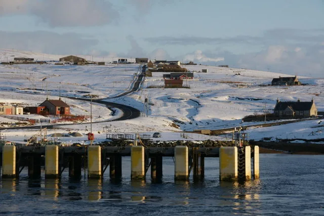
Bay of Ulsta
Bay of Ulsta — a natural feature in scotland islands.

James Allan — CC BY-SA 2.0 via Wikimedia Commons licence
Plan your visit
- Typical visit
- 1 h–2 h
About
Bay of Ulsta is a named natural feature in scotland islands, recorded in the GeoNames UK gazetteer. British landmarks of this type are typically marked on Ordnance Survey maps and recorded in the national gazetteer for cartographic and navigational reference. Coordinates and feature classification are sourced from the GeoNames open dataset.
Photo gallery
Place summary
The Bay of Ulsta is a natural landmark located in the Scottish Islands. It is known for its rugged coastline and scenic views. The bay is part of a wider landscape that features dramatic cliffs and diverse marine life, attracting nature enthusiasts and photographers. The area's natural beauty offers opportunities for walking and exploration along the shore.
AI-generated from the structured facts on this page (operator, designation, listing, era). Not a substitute for visiting.
- Coordinates
- 60.5000, -1.1500
Sources
- manual: geonames-2635187 (CC BY 4.0)
Other places nearby
Loading nearby places…
Nearby
📷 5Villages · Scottish Islands
Ulsta
Ulsta — a village in scotland islands.
 📷 5
📷 5Historic houses · Scottish Islands
Ulsta
Ulsta in Orkney + Shetland, United Kingdom.
 📷 3
📷 3Mountains & hills · Scottish Islands
Bay of Ulsta
Bay of Ulsta — bay on Yell, Shetland Islands, Scotland, UK.
 📷 5
📷 5Mountains & hills · Scottish Islands
Ward of Copister
Ward of Copister — mountain in scotland islands. Elevation: 77 m.
 📷 5
📷 5Mountains & hills · Scottish Islands
Hill of Clothan
Hill of Clothan — mountain in scotland islands. Elevation: 107 m.
 📷 4
📷 4Beaches · Scottish Islands
Copister
Copister in Orkney + Shetland, United Kingdom.
Where to eat & stay near Bay of Ulsta
Places to stay
 📷 5
📷 5Campsites · Scottish Islands
Burravoe Pier Trust Campsite
Burravoe Pier Trust Campsite — a campsite in scotland islands.
 📷 5
📷 5Hostels · Scottish Islands
Wind Lodge Bod
Wind Lodge Bod — a hostel in scotland islands.
 📷 5
📷 5Hostels · Scottish Islands
The Sail Loft
The Sail Loft — a hostel in scotland islands.
 📷 5
📷 5Campsites · Scottish Islands
Oot Ower Lounge
Oot Ower Lounge — a campsite in scotland islands.
 📷 5
📷 5Hostels · Scottish Islands
Aithbank Camping Böd
Aithbank Camping Böd — a hostel in scotland islands.
 📷 5
📷 5Caravan parks · Scottish Islands
Braewick Caravan Park
Braewick Caravan Park — a caravan park in scotland islands.


More natural landmarks in this region
 📷 5
📷 5Natural landmarks · Scottish Islands
Clickimin Loch
Clickimin Loch — freshwater lake at Lerwick, Shetland Mainland, Shetland Islands, Scotland, UK.
 📷 3
📷 3Natural landmarks · Scottish Islands
Lairo Water
Lairo Water — lake on Shapinsay, Orkney Islands, Scotland, UK.
 📷 3
📷 3Natural landmarks · Scottish Islands
Little Water
Little Water — freshwater lake on Whalsay, Shetland Islands, Scotland, UK.
 📷 3
📷 3Natural landmarks · Scottish Islands
Loch Isbister
Loch Isbister — lake in Shetland Islands, Scotland, UK.
Frequently asked questions
- Where is Bay of Ulsta?
- Bay of Ulsta is in the Scottish Islands, United Kingdom.
- What is Bay of Ulsta?
- Bay of Ulsta — a natural feature in scotland islands.
- How do I get to Bay of Ulsta?
- Its coordinates are 60.5000°, -1.1500°.