Natural landmarks · Scottish Islands
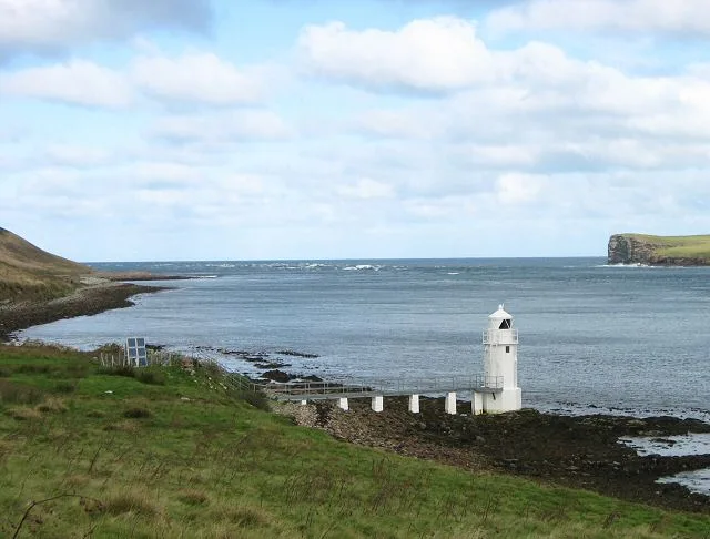
Bay of Doomy
Bay of Doomy — a natural feature in scotland islands.

Colin Park — CC BY-SA 2.0 via Wikimedia Commons licence
Plan your visit
- Typical visit
- 1 h–2 h
About
Bay of Doomy is a named natural feature in scotland islands, recorded in the GeoNames UK gazetteer. British landmarks of this type are typically marked on Ordnance Survey maps and recorded in the national gazetteer for cartographic and navigational reference. Coordinates and feature classification are sourced from the GeoNames open dataset.
Photo gallery
Place summary
The Bay of Doomy is a natural landmark located in the Scottish Islands. It is characterised by its rugged coastline and dramatic scenery, typical of the region's maritime landscape. Visitors can expect a picturesque setting that showcases the unique geological features of the area. The bay is an example of the natural beauty that defines the Scottish Isles.
AI-generated from the structured facts on this page (operator, designation, listing, era). Not a substitute for visiting.
- Coordinates
- 59.1972, -2.7791
Sources
- manual: geonames-11153587 (CC BY 4.0)
Other places nearby
Loading nearby places…
Nearby
 📷 5
📷 5Natural landmarks · Scottish Islands
Bay of London
Bay of London — a natural feature in scotland islands.
 📷 5
📷 5Hostels · Scottish Islands
Eday Community Youth Hostel
Eday Community Youth Hostel — a hostel in scotland islands.
 📷 4
📷 4Other places · Scottish Islands
Eday Airport
Eday Airport in Orkney + Shetland, United Kingdom.
 📷 3
📷 3Museums · Scottish Islands
Eday Heritage & Visitor Centre
Eday Heritage & Visitor Centre — a museum in scotland-islands, United Kingdom.
 Flagship📷 5
Islands · Scottish Islands
Eday
Eday — island of the Orkney islands, Scotland, UK.
 📷 5
📷 5Mountains & hills · Scottish Islands
Stennie Hill
Stennie Hill — mountain in scotland islands. Elevation: 66 m.
Where to eat & stay near Bay of Doomy
Places to stay
📷 5Hostels · Scottish Islands
Eday Community Youth Hostel
Eday Community Youth Hostel — a hostel in scotland islands.
 📷 5
📷 5Campsites · Scottish Islands
Ayres Rock Hostel & Campsite
Ayres Rock Hostel & Campsite — a campsite in scotland islands.
📷 5Hostels · Scottish Islands
Ayres Rock Hostel
Ayres Rock Hostel — a hostel in scotland islands.
 📷 5
📷 5Campsites · Scottish Islands
Trumland Hostel & Campsite
Trumland Hostel & Campsite — a campsite in scotland islands.
📷 5Hostels · Scottish Islands
Trumland Hostel & Campsite
Trumland Hostel & Campsite — a hostel in scotland islands.
 📷 5
📷 5Campsites · Scottish Islands
Chalmersquoy Camping
Chalmersquoy Camping — a campsite in scotland islands.
More natural landmarks in this region
 📷 5
📷 5Natural landmarks · Scottish Islands
Clickimin Loch
Clickimin Loch — freshwater lake at Lerwick, Shetland Mainland, Shetland Islands, Scotland, UK.
 📷 3
📷 3Natural landmarks · Scottish Islands
Lairo Water
Lairo Water — lake on Shapinsay, Orkney Islands, Scotland, UK.
 📷 3
📷 3Natural landmarks · Scottish Islands
Little Water
Little Water — freshwater lake on Whalsay, Shetland Islands, Scotland, UK.
 📷 3
📷 3Natural landmarks · Scottish Islands
Loch Isbister
Loch Isbister — lake in Shetland Islands, Scotland, UK.
Frequently asked questions
- Where is Bay of Doomy?
- Bay of Doomy is in the Scottish Islands, United Kingdom.
- What is Bay of Doomy?
- Bay of Doomy — a natural feature in scotland islands.
- How do I get to Bay of Doomy?
- Its coordinates are 59.1972°, -2.7791°.