
Forts · North West England
Battle of Winwick
Also known as: Red Bank
In or near Winwick.
Battle of Winwick is a fort in the United Kingdom.

Wikimedia Commons licence
Plan your visit
- Typical visit
- 45 min–1.5 h
- Nearest railway station
- Newton-le-Willows · 1.4 km
Getting there & planning your visit
The Battle of Winwick is located in Warrington, with the nearest railway station being Newton-le-Willows, approximately 1.4 km away. The postcode for the site is WA2 8SJ. Entry information is not provided, so please check before your visit.
About
Battle of Winwick is a historic fort or fortified site in the United Kingdom. Also known as: Red Bank. Coordinates: 53.4408°, -2.6067°.
Photo gallery
From the Wikipedia article
The Battle of Winwick (also known as the Battle of Red Bank) was fought on 19 August 1648 near the Lancashire village of Winwick between part of a Royalist army under Lieutenant General William Baillie and a Parliamentarian army commanded by Lieutenant General Oliver Cromwell. The Royalists were defeated with all of those who took part in the fighting, their army's entire infantry force, either killed or captured. The Royalist mounted component fled but surrendered five days after the battle. Winwick was the last battle of the Second English Civil War. The First English Civil War between Royalist supporters of Charles I and an alliance of Parliamentarian and Scottish forces ended in 1646 with Charles defeated and a prisoner. He continued to negotiate with several factions among his opponents and this sparked the Second English Civil War in 1648: a series of mutinies and Royalist uprisings in England and Wales, and a Scottish Royalist invasion of north-west England. The invading army was attacked and defeated by a smaller Parliamentarian army at the battle of Preston on 17 August. The majority of the Royalists, mostly Scots, had not been engaged but they fled south, closely pursued by the Parliamentarians, mostly of the New Model Army. On 19 August, hungry, cold, soaking wet, exhausted and short of dry powder, the Scottish infantry turned to fight at Winwick. Their cavalry waited 3 miles (5 km) away at Warrington. The Parliamentarian advance guard was put to flight with heavy casualties. After a lengthy pause, Parliamentarian infantry arrived: they attempted to storm the Scottish position and were thrown back. A full-scale assault was then launched which resulted in more than three hours of furious but indecisive close-quarters fighting. The Parliamentarians fell back again, pinned the Scots in place with their cavalry and sent their infantry on a circuitous flank march. As soon as the Scots saw this force appear on their right flank they broke and fled.…
Excerpt from Wikipedia under CC BY-SA 4.0. See the source article linked in Sources below.
Background
History
In 1639, and again in 1640, Charles I, who was king of both Scotland and England in a personal union, went to war with his Scottish subjects in the Bishops' Wars. These had arisen from the Scots' refusal to accept Charles's attempts to reform the Scottish Kirk to bring it into line with English religious practices. Charles was not successful in these endeavours and the ensuing settlement with his Scottish Parliament in 1641 severely limited his powers. After years of rising tensions the relationship between Charles and his English Parliament broke down, starting the First English Civil War in 1642. In England Charles's supporters, the Royalists, were opposed by the combined forces of the…
Sourced from Wikipedia under CC BY-SA 4.0.
- Coordinates
- 53.4408, -2.6067
- District
- Warrington
- Parish
- Winwick
- Postcode
- WA2 8SJ
- Parliamentary constituency
- Warrington North
- Nearest railway station
- Newton-le-Willows — 1.4 km
Sources
- osm: n9025329190 (ODbL)
- wikipedia: Battle of Winwick (CC BY-SA 4.0)
Other places nearby

1648 Battle of Red Bank
Memorials & monuments · 0.2 km

St Oswalds Well
Archaeological sites · 0.9 km

Newton-le-Willows Cemetery
Cemeteries · 1.1 km
Gardens of Remembrance
Memorials & monuments · 1.1 km
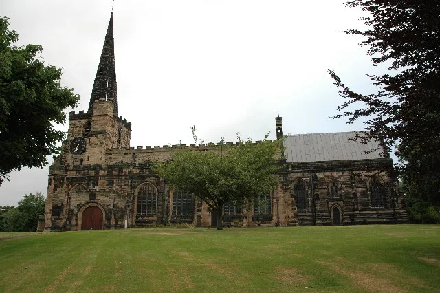
St Oswald's Church, Winwick
Historic churches · 1.3 km

Winwick
Towns & cities · 1.3 km

Mill Lane Viaduct
Historic bridges · 1.5 km

Huskisson Memorial, Newton-le-Willows
Memorials & monuments · 1.7 km
Huskisson Memorial
Memorials & monuments · 1.7 km

Newton Stocks
Memorials & monuments · 1.8 km

Norman Harvey memorial
Memorials & monuments · 1.9 km

Newton-le-Willows
Villages · 2.1 km
Nearby
📷 3Memorials & monuments · North West England
1648 Battle of Red Bank
1648 Battle of Red Bank — a memorial in wales-north, United Kingdom.
📷 3Archaeological sites · North West England
St Oswalds Well
St Oswalds Well — a archaeological in england-west-midlands, United Kingdom.
📷 5Cemeteries · North West England
Newton-le-Willows Cemetery
Newton-le-Willows Cemetery is a cemetery in the United Kingdom.
📷 3Memorials & monuments · North West England
Gardens of Remembrance
Gardens of Remembrance — a memorial in wales-north, United Kingdom.
📷 4Historic churches · North West England
St Oswald's Church, Winwick
St Oswald's Church, Winwick — church in Winwick, Cheshire, England, UK.
📷 5Towns & cities · North West England
Winwick
Winwick — village and civil parish in Warrington, Cheshire, United Kingdom.
Where to eat & stay near Battle of Winwick
Places to stay
 📷 5
📷 5Hostels · North West England
Riverside Project
Riverside Project — a hostel in england west midlands.
Caravan parks · North West England
Sherdley Road Caravan Site
Sherdley Road Caravan Site — a caravan park in england north west.
 📷 5
📷 5 📷 5
📷 5Caravan parks · North West England
Canal Bank Farm caravan site
Canal Bank Farm caravan site — a caravan park in england west midlands.
 📷 5
📷 5 📷 5
📷 5Caravan parks · North West England
Meadow Bank Caravan Park
Meadow Bank Caravan Park — a caravan park in wales north.
Places to eat & drink
 📷 5
📷 5Restaurants · North West England
Galleries Cafe
Galleries Cafe — a restaurant in wales north.
 📷 5
📷 5Historic pubs · North West England
The Wheatsheaf, St Helens
The Wheatsheaf, St Helens in Wales North, United Kingdom.
 📷 5
📷 5Historic pubs · North West England
Q26664383
Q26664383 in England North West, United Kingdom.
 📷 7
📷 7Historic pubs · North West England
Dog and Partridge
Dog and Partridge in England North West, United Kingdom.
 📷 5
📷 5Historic pubs · North West England
John Bull Chop House
John Bull Chop House — Historic pub — listed building or notable heritage status.
 📷 7
📷 7Historic pubs · North West England
The Whitesmiths Arms
The Whitesmiths Arms in England North West, United Kingdom.
More forts in this region
 📷 3
📷 3 📷 5
📷 5Forts · North West England
Obelisk in Whiteoaks Wood
Obelisk in Whiteoaks Wood — a martello broad in england-west-midlands, United Kingdom.
 📷 5
📷 5Forts · North West England
Obelisk At Rode Hall
Obelisk At Rode Hall — a martello broad in england-west-midlands, United Kingdom.
 📷 5
📷 5Forts · North West England
The Stanley Obelisk
The Stanley Obelisk — a martello broad in england-west-midlands, United Kingdom.
Frequently asked questions
- Where is Battle of Winwick?
- Battle of Winwick is in North-West England, United Kingdom (postcode WA2 8SJ), in the parish of Winwick.
- What is Battle of Winwick?
- Battle of Winwick is a fort in the United Kingdom.
- How do I get to Battle of Winwick?
- The nearest railway station is Newton-le-Willows, about 1.4 km away. The nearest town is Winwick. Drivers can use postcode WA2 8SJ.
- How do I get to Battle of Winwick?
- The nearest railway station is Newton-le-Willows, about 1.4 km away. Drivers can navigate to postcode WA2 8SJ.