
Historic churches · East Midlands
Barrowby
In or near Harlaxton.
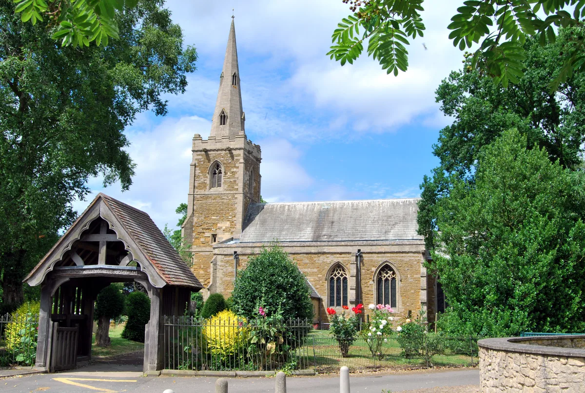
Barrowby is a village and civil parish in the South Kesteven district of Lincolnshire, England. It is 2 miles (3.2 km) west of Grantham. It overlooks the Vale of Belvoir and has a Grade I listed paris

David Dixon — CC BY-SA 2.0 via Wikimedia Commons licence

Plan your visit
- Typical visit
- 30 min–1 h
- Nearest railway station
- Grantham · 3.5 km
- Free entry
Getting there & planning your visit
To visit Barrowby church in Lincolnshire, the nearest railway station is Grantham, located 3.5 km away. The postcode for sat-nav is NG32 1DA, and entry to the church is free.
About
Barrowby is a village and civil parish in the South Kesteven district of Lincolnshire, England. It is 2 miles (3.2 km) west of Grantham. It overlooks the Vale of Belvoir and has a Grade I listed parish church. The hamlet of Casthorpe is part of the parish. The 2001 Census listed 795 households and a population of 1,996, which fell to 840 households with 1,952 inhabitants at the 2011 census. It was estimated at 1,986 in 2019.
Photo gallery
From the Wikipedia article
Barrowby is a village and civil parish in the South Kesteven district of Lincolnshire, England. It is 2 miles (3.2 km) west of Grantham. It overlooks the Vale of Belvoir and has a Grade I listed parish church. The hamlet of Casthorpe is part of the parish. The 2001 Census listed 795 households and a population of 1,996, which fell to 840 households with 1,952 inhabitants at the 2011 census. It was estimated at 1,986 in 2019.
Excerpt from Wikipedia under CC BY-SA 4.0. See the source article linked in Sources below.
Background
History
The Domesday Book record shows there was a church with a priest and 60 acre of meadow. The village belonged until the 19th century to the historical wapentake of Winnibriggs and Threo. The Domesday village of Casthorpe is 1.5 mi west from Barrowby. By the 14th century it was referred to in records as two holdings, East and West Casthorpe. It is now little more than a cluster of farm buildings. A further deserted medieval village is Newbo, 1.5 mi to the north-west, site of Newbo Abbey. The village was located by archaeologists in 1970.
Sourced from Wikipedia under CC BY-SA 4.0.
- Coordinates
- 52.9170, -0.6920
- County
- Lincolnshire
- District
- South Kesteven
- Parish
- Barrowby
- Postcode
- NG32 1DA
- Parliamentary constituency
- Grantham and Bourne
- Nearest railway station
- Grantham — 3.5 km
Sources
- wikipedia: Barrowby (CC BY-SA 4.0)
Other places nearby
All Saints Church
Historic churches · 0.3 km

Mill Hill
Mountains & hills · 0.6 km

Stubbock Hill
Mountains & hills · 1.2 km

Casthorpe Hills
Mountains & hills · 1.5 km

The West Grantham Academy St Hugh's
Natural landmarks · 2.2 km

Newbo Abbey
Abbeys & priories · 2.4 km
Newbo Abbey
Cathedrals · 2.4 km

Denton Canal Bridge (No 65 On Grantham Canal)
Historic bridges · 2.5 km

Grantham Canal, Vincents Bridge On Grantham Canal
Historic bridges · 2.6 km

Great Gonerby
Historic churches · 2.6 km

Fun Farm
Theme parks · 2.7 km

Sedgebrook
Historic churches · 3.0 km
Nearby
📷 3Historic churches · East Midlands
All Saints Church
All Saints Church — church in Barrowby, Lincolnshire, England, UK.
📷 5Mountains & hills · East Midlands
Mill Hill
Mill Hill — mountain in england east midlands. Elevation: 105 m.
📷 5Mountains & hills · East Midlands
Stubbock Hill
Stubbock Hill — mountain in england east midlands. Elevation: 111 m.
📷 5Mountains & hills · East Midlands
Casthorpe Hills
Casthorpe Hills — a hill or mountain in england east midlands.
📷 5Natural landmarks · East Midlands
The West Grantham Academy St Hugh's
The West Grantham Academy St Hugh's — a school heritage in england-east-midlands, United Kingdom.
📷 3Abbeys & priories · East Midlands
Newbo Abbey
Newbo Abbey — Premonstratensian abbey in Lincolnshire, England, UK.
Where to eat & stay near Barrowby
Places to stay
 📷 5
📷 5 📷 5
📷 5Caravan parks · East Midlands
Wagtail Country Park
Wagtail Country Park — a caravan park in england east midlands.
 📷 5
📷 5Campsites · East Midlands
Woodland Waters
Woodland Waters — a campsite in england east midlands.
 📷 5
📷 5Campsites · East Midlands
Fair Farm
Fair Farm — a campsite in england east midlands.
 📷 5
📷 5Caravan parks · East Midlands
The Landings at Langar
The Landings at Langar — a caravan park in england east midlands.
 📷 5
📷 5Places to eat & drink
 📷 7
📷 7Historic pubs · East Midlands
Black Dog Public House
Black Dog Public House in England East, United Kingdom.
 📷 6
📷 6Historic pubs · East Midlands
Blue Man Public House
Blue Man Public House in England East, United Kingdom.
 📷 6
📷 6 📷 7
📷 7Historic pubs · East Midlands
47 and 48 High Street
47 and 48 High Street in England East, United Kingdom.
 📷 7
📷 7Historic pubs · East Midlands
The Muston Gap Public House
The Muston Gap Public House in England East Midlands, United Kingdom.
 📷 5
📷 5More places in this region
 📷 5
📷 5Historic churches · East Midlands
All Saints' Church, Stamford
All Saints' Church, Stamford — church in Stamford, Lincolnshire, England, UK.
 📷 5
📷 5Historic churches · East Midlands
Church of All Saints
Church of All Saints — church in Little Casterton, Rutland, United Kingdom.
 📷 5
📷 5Historic churches · East Midlands
Church of All Saints
Church of All Saints — church in Fenland, UK.
 📷 5
📷 5Historic churches · East Midlands
Church of St Leonard
Church of St Leonard — church in Fenland, UK.
Frequently asked questions
- Where is Barrowby?
- Barrowby is in Lincolnshire, the East Midlands, United Kingdom (postcode NG32 1DA), in the parish of Barrowby.
- What is Barrowby?
- Barrowby is a village and civil parish in the South Kesteven district of Lincolnshire, England. It is 2 miles (3.2 km) west of Grantham. It overlooks the Vale of Belvoir and has a Grade I listed paris
- How do I get to Barrowby?
- The nearest railway station is Grantham, about 3.5 km away. Drivers can use postcode NG32 1DA.
- Is Barrowby free to visit?
- Yes, Barrowby is free to enter.
- How do I get to Barrowby?
- The nearest railway station is Grantham, about 3.5 km away. Drivers can navigate to postcode NG32 1DA.