
Museums · East of England
Babergh District
In or near Aldham.
Babergh District (pronounced , BAY-bə) is a local government district in Suffolk, England. In 2021 it had a population of 92,300. The district is primarily a rural area, containing just two towns, Sud

Robert Edwards — CC BY-SA 2.0 via Wikimedia Commons licence

Plan your visit
- Typical visit
- 1.5 h–3 h
- Best time of year
- Year-round
- Family-friendly
- Limited wheelchair access
About
Babergh District (pronounced , BAY-bə) is a local government district in Suffolk, England. In 2021 it had a population of 92,300. The district is primarily a rural area, containing just two towns, Sudbury and Hadleigh. The council was based in Hadleigh until 2017, when it moved to shared offices with neighbouring Mid Suffolk District Council in Ipswich, outside either district. The district is named after the medieval Babergh Hundred, which covered part of the area. The district includes parts of two designated Areas of Outstanding Natural Beauty, Dedham Vale, known for its association with painter John Constable, and Suffolk Coast and Heaths. The neighbouring districts are East Suffolk, Ipswich, Mid Suffolk, West Suffolk, Braintree, Colchester and Tendring.
Photo gallery
From the Wikipedia article
Babergh District (pronounced , BAY-bə) is a local government district in Suffolk, England. In 2021 it had a population of 92,300. The district is primarily a rural area, containing just two towns, Sudbury and Hadleigh. The council was based in Hadleigh until 2017, when it moved to shared offices with neighbouring Mid Suffolk District Council in Ipswich, outside either district. The district is named after the medieval Babergh Hundred, which covered part of the area. The district includes parts of two designated Areas of Outstanding Natural Beauty, Dedham Vale, known for its association with painter John Constable, and Suffolk Coast and Heaths. The neighbouring districts are East Suffolk, Ipswich, Mid Suffolk, West Suffolk, Braintree, Colchester and Tendring.
Excerpt from Wikipedia under CC BY-SA 4.0. See the source article linked in Sources below.
Background
History
The district was created on 1 April 1974 under the Local Government Act 1972, covering five former districts which were all abolished at the same time: Samford Rural District had been in the administrative county of East Suffolk prior to the reforms; the other districts had all been in West Suffolk. The new district was named Babergh after the medieval hundred of Babergh, which had covered part of the area. Babergh Hundred is referred to in the Domesday Book of 1086; the modern district covers a larger area than the historic hundred, also covering the hundreds of Cosford and Samford. The council's logo now says "Babergh District Council – South Suffolk". Under upcoming local government…
Sourced from Wikipedia under CC BY-SA 4.0.
- Coordinates
- 52.0480, 0.9480
- County
- Suffolk
- District
- Babergh
- Parish
- Hadleigh
- Postcode
- IP7 6RW
- Parliamentary constituency
- South Suffolk
- Official site
- www.babergh.gov.uk
Sources
- wikipedia: Babergh District (CC BY-SA 4.0)
Other places nearby

21, Bridge Street
Historic pubs · 0.0 km

Bridge Over The River Brett
Historic bridges · 0.1 km

124 and 126, High Street
Historic houses · 0.3 km

124 and 126, High Street
Historic pubs · 0.3 km
106, High Street
Historic pubs · 0.4 km

Hadleigh
Villages · 0.5 km
Huffers Café and Restaurant
Cafés · 0.5 km

Deanery Tower
Memorials & monuments · 0.6 km
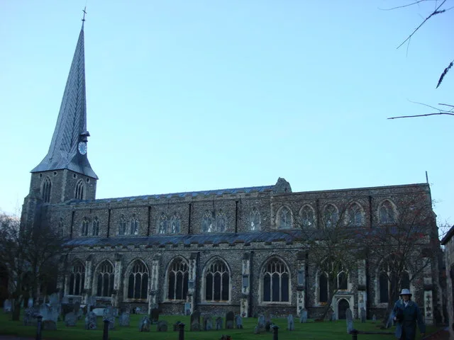
St Mary, Hadleigh
Historic churches · 0.6 km

Fork
Restaurants · 0.6 km

The Royal Bengal
Restaurants · 0.6 km

Hadleigh Town Sign
Public art & sculpture · 0.7 km
Nearby
📷 5📷 3Historic bridges · East of England
Bridge Over The River Brett
Bridge Over The River Brett — Grade II listed building-listed bridge in england-east, United Kingdom.
📷 3Historic houses · East of England
124 and 126, High Street
124 and 126, High Street — building in Hadleigh, Suffolk, England, UK.
📷 5Historic pubs · East of England
124 and 126, High Street
124 and 126, High Street in England East, United Kingdom.
📷 6📷 5Where to eat & stay near Babergh District
Places to stay
 📷 7
📷 7 📷 5
📷 5 📷 5
📷 5Caravan parks · East of England
Polstead Camping & Caravan Site
Polstead Camping & Caravan Site — a caravan park in england east.
 📷 5
📷 5Campsites · East of England
White Horse Inn Camp Site
White Horse Inn Camp Site — a campsite in england east.
 📷 5
📷 5 📷 5
📷 5Campsites · East of England
Tomcat Farm Caravan Services
Tomcat Farm Caravan Services — a campsite in england east.
Places to eat & drink
📷 5📷 5Historic pubs · East of England
124 and 126, High Street
124 and 126, High Street in England East, United Kingdom.
📷 6📷 6Cafés · East of England
Huffers Café and Restaurant
Huffers Café and Restaurant — a café in england east. Cuisine: coffee shop;regional.
📷 7📷 6More museums in this region
 📷 5
📷 5Museums · East of England
American Air Museum
American Air Museum — museum at Imperial War Museum Duxford, Cambridgeshire, England, UK.
 📷 5
📷 5Museums · East of England
Ashwell Village Museum
Ashwell Village Museum — historic building museum in Ashwell, Hertfordshire, England, United Kingdom.
 📷 5
📷 5Museums · East of England
Barleylands Farm Museum
Barleylands Farm Museum — Farm museum in Billericay, England.
 📷 5
📷 5Museums · East of England
Cromwell Museum
Cromwell Museum — museum in Huntingdon, England, United Kingdom.
Frequently asked questions
- Where is Babergh District?
- Babergh District is in Suffolk, East of England, United Kingdom (postcode IP7 6RW), in the parish of Hadleigh.
- What is Babergh District?
- Babergh District (pronounced , BAY-bə) is a local government district in Suffolk, England. In 2021 it had a population of 92,300. The district is primarily a rural area, containing just two towns, Sud
- How do I get to Babergh District?
- Drivers can use postcode IP7 6RW.
- Who owns Babergh District?
- Babergh District is owned by Babergh District Council.
- How do I get to Babergh District?
- Drivers can navigate to postcode IP7 6RW. It sits within the South Suffolk parliamentary constituency.