Museums · London
Ashtead
In or near Great Bookham.
Ashtead is a village in the Mole Valley district of Surrey, England, approximately 16 miles (26 kilometres) south of central London. Ashtead is on the single-carriageway A24 between Epsom and Leathe

P L Chadwick — CC BY-SA 2.0 via Wikimedia Commons licence
Plan your visit
- Typical visit
- 1.5 h–3 h
- Best time of year
- Year-round
- Nearest railway station
- Ashtead · 1.1 km
- Family-friendly
- Limited wheelchair access
Getting there & planning your visit
To visit Ashtead Museum, the nearest railway station is Ashtead, located 1.1 km away. Entry is free, but please note that wheelchair accessibility is limited. The postcode for sat-nav is KT21 1AW.
About
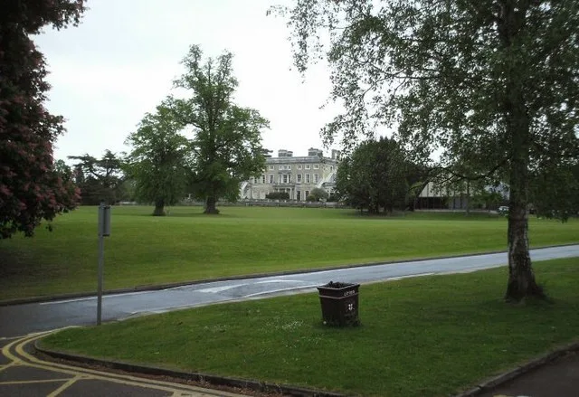
Ashtead is a village in the Mole Valley district of Surrey, England, approximately 16 miles (26 kilometres) south of central London. Ashtead is on the single-carriageway A24 between Epsom and Leatherhead. The village is on the northern slopes of the North Downs and is in the catchment area of The Rye, a tributary of the River Mole. The earliest archaeological evidence for human activity in the village is from the Stone Age. At several points in its history, including during the early Roman period, Ashtead has been a centre for brick and tile manufacture. From medieval times until the late 19th century, Ashtead was primarily an agricultural settlement. Residential development was catalysed by the opening of the railway line between Epsom and Leatherhead in 1859 and by the breakup of the Ashtead Park estate in the 1880s. Housebuilding continued into the 20th century, reaching a peak in the 1930s. Future expansion is now constrained by the Metropolitan Green Belt, which encircles the village. There are two nature reserves in the village: Ashtead Common, to the north west of the centre, forms part of a Site of Special Scientific Interest and is owned by the Corporation of London; Ashtead Park, to the east of the centre is a Local Nature Reserve owned by the District Council.
Photo gallery
From the Wikipedia article
Ashtead is a village in the Mole Valley district of Surrey, England, approximately 16 miles (26 kilometres) south of central London. Ashtead is on the single-carriageway A24 between Epsom and Leatherhead. The village is on the northern slopes of the North Downs and is in the catchment area of The Rye, a tributary of the River Mole. The earliest archaeological evidence for human activity in the village is from the Stone Age. At several points in its history, including during the early Roman period, Ashtead has been a centre for brick and tile manufacture. From medieval times until the late 19th century, Ashtead was primarily an agricultural settlement. Residential development was catalysed by the opening of the railway line between Epsom and Leatherhead in 1859 and by the breakup of the Ashtead Park estate in the 1880s. Housebuilding continued into the 20th century, reaching a peak in the 1930s. Future expansion is now constrained by the Metropolitan Green Belt, which encircles the village. There are two nature reserves in the village: Ashtead Common, to the north west of the centre, forms part of a Site of Special Scientific Interest and is owned by the Corporation of London; Ashtead Park, to the east of the centre is a Local Nature Reserve owned by the District Council.
Excerpt from Wikipedia under CC BY-SA 4.0. See the source article linked in Sources below.
- Coordinates
- 51.3100, -0.2990
- County
- Surrey
- District
- Mole Valley
- Parish
- Mole Valley, unparished area
- Postcode
- KT21 1AW
- Parliamentary constituency
- Epsom and Ewell
- Nearest railway station
- Ashtead — 1.1 km
- Official site
- web.archive.org
Sources
- wikipedia: Ashtead (CC BY-SA 4.0)
Other places nearby

The Leg Of Mutton And Cauliflower Public House
Historic pubs · 0.1 km

Bridge At Rookery Hill
Historic bridges · 0.6 km

Parsons Mead School
Natural landmarks · 0.7 km

Hamelot Monument Approximately 18 Metres South East Of Chancel Of Church Of St Giles
Memorials & monuments · 0.7 km
Ashtead Park
Parks · 0.9 km

St Andrew's Catholic School
Historic churches · 1.4 km

Stane Street (BY 118)
Mountain bike trails · 1.6 km

Ashtead Commons Concessionary Ride 2
Mountain bike trails · 1.6 km

Woodcote Park
Manor houses · 1.7 km

Ashtead Commons Concessionary Ride 4
Mountain bike trails · 1.7 km
.jpg?width=1200)
Ashtead Common
Forests & woodlands · 1.7 km

Ashtead Commons Concessionary Ride 2
Mountain bike trails · 1.8 km
Nearby
📷 5Historic pubs · London
The Leg Of Mutton And Cauliflower Public House
The Leg Of Mutton And Cauliflower Public House in England London, United Kingdom.
📷 5Historic bridges · London
Bridge At Rookery Hill
Bridge At Rookery Hill — Grade II listed building-listed bridge in england-london, United Kingdom.
📷 5Natural landmarks · London
Parsons Mead School
Parsons Mead School — a school heritage in england-london, United Kingdom.
📷 5Memorials & monuments · London
Hamelot Monument Approximately 18 Metres South East Of Chancel Of Church Of St Giles
Hamelot Monument Approximately 18 Metres South East Of Chancel Of Church Of St Giles — Grade II listed building-listed memorial in england-london, United Kingdom.
📷 10📷 5Historic churches · London
St Andrew's Catholic School
St Andrew's Catholic School — a school heritage in england-london, United Kingdom.
Where to eat & stay near Ashtead
Places to stay
 📷 7
📷 7Hotels · London
Woodlands Park Hotel
Woodlands Park Hotel — a hotel in england london.
 📷 5
📷 5Campsites · London
Polyapes Scout Camp
Polyapes Scout Camp — a campsite in england london.
 📷 5
📷 5 📷 5
📷 5Campsites · London
Banstead & District Scout Campsite
Banstead & District Scout Campsite — a campsite in england london.
 📷 5
📷 5Hotels · South East England
Hartsfield Manor
Hartsfield Manor — a hotel in england london.
 📷 5
📷 5Caravan parks · South East England
Conifer Park Caravan Site
Conifer Park Caravan Site — a caravan park in england london.
Places to eat & drink
📷 5Historic pubs · London
The Leg Of Mutton And Cauliflower Public House
The Leg Of Mutton And Cauliflower Public House in England London, United Kingdom.
 📷 5
📷 5Historic pubs · London
The Cricketers Public House
The Cricketers Public House in England London, United Kingdom.
 📷 5
📷 5 📷 5📷 5
Historic pubs · London
Marquis Of Granby Public House
Marquis Of Granby Public House in England London, United Kingdom.
 📷 5
📷 5Historic pubs · London
The Wellington Public House
The Wellington Public House in England London, United Kingdom.
More museums in this region
 Flagship📷 10
Museums · London
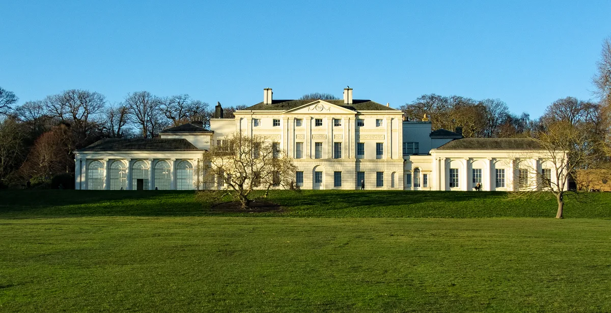
Kenwood House
Kenwood House — art museum and historic house in Hampstead, London.
 📷 5
📷 5Museums · London
Amora London
Amora London — European touring exhibition dedicated to love, relationships and sexual wellbeing.
 📷 5
📷 5Museums · London
Antique Breadboard Museum
Antique Breadboard Museum — small museum in Putney, London, England, UK.
 📷 5
📷 5Museums · London
Arsenal Football Club Museum
Arsenal Football Club Museum — sports museum in London.
Frequently asked questions
- Where is Ashtead?
- Ashtead is in Surrey, London, United Kingdom (postcode KT21 1AW), in the parish of Mole Valley, unparished area.
- What is Ashtead?
- Ashtead is a village in the Mole Valley district of Surrey, England, approximately 16 miles (26 kilometres) south of central London. Ashtead is on the single-carriageway A24 between Epsom and Leathe
- How do I get to Ashtead?
- The nearest railway station is Ashtead, about 1.1 km away. Drivers can use postcode KT21 1AW.
- How do I get to Ashtead?
- The nearest railway station is Ashtead, about 1.1 km away. Drivers can navigate to postcode KT21 1AW.