
Towns & cities · East of England
Anstey
Also known as: Anstey, Swydd Hertford
Anstey — village and civil parish in the East Hertfordshire, England.

Wikimedia Commons contributors — see linked file page for photographer and licence licence

Plan your visit
- Typical visit
- 3 h–6 h
- Nearest railway station
- Royston · 9.8 km
- Free entry
- Family-friendly
- Dog-friendly
Getting there & planning your visit
Anstey is located in East Hertfordshire, with the nearest railway station being Royston, approximately 9.8 km away. The postcode for Anstey is SG9 0BY. Entry to the town is free.
About
Anstey is a town, city, village or settlement in the United Kingdom. Recent population estimates put it at around 299 people. Wikidata describes it as: "village and civil parish in the East Hertfordshire, England". Coordinates: 51.9764°, 0.0436°.
Photo gallery
From the Wikipedia article
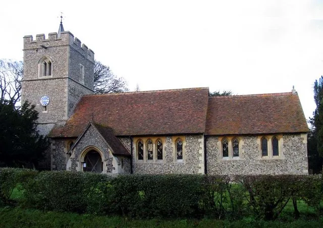
Anstey is a village and civil parish in the East Hertfordshire district of Hertfordshire, England. It lies 3 miles (5 km) north-east of Buntingford, its post town. At the 2021 census the parish had a population of 306. The name "Anstey" derives from the Old English ān (narrow, or one-way) and stīg (footpath). There are at least two books on the history of this village. The first is Anstey, a Hertfordshire Parish, written in 1929 by Rev Frank Ricardo Williams, MA, who was the rector from 1907 to 1928 (died 19 May 1937). The second is Anstey: Our True Surname Origin and Shared Medieval Ancestry by GM Anstey and TJ Anstey in which it is shown that all bearers of the surname 'Anstey' worldwide can trace their surname origin to Anstey in Hertfordshire. The Church of England parish church of Saint George is a cruciform building of flint with stone dressings. Its earliest parts are the chancel, transepts and crossing tower, all of which were built in the 12th century. The church was altered in the 13th century and the nave was rebuilt in the 14th century. The south porch and the top stage of the tower are 15th century. The church was restored in 1871–72 under the direction of the Gothic Revival architect William Butterfield. Repairs in 1907 were directed by the architect Arthur Blomfield. St George's is a Grade I listed building. The lychgate is a separate Grade II listed building, as it incorporates a lockup which was apparently used until the beginning of the 20th century. In his book 'England's Thousand best churches' (revised edition 2002), Simon Jenkins refers to a near-miss when a fully loaded WW2 bomber nearly crashed into the church. This is reference to the crash of a Flying Fortress which crashed on take-off en route to Cologne: all ten crew were killed. Jenkins refers to the church as 'full of Norman mystery'. He pays particular interest to the church font, in which (and very unusually) four mermen are carved into the stone. Jenkins refers to the carvings as…
Excerpt from Wikipedia under CC BY-SA 4.0. See the source article linked in Sources below.
- Coordinates
- 51.9764, 0.0436
- County
- Hertfordshire
- District
- East Hertfordshire
- Parish
- Anstey
- Postcode
- SG9 0BY
- Parliamentary constituency
- North East Hertfordshire
- Population
- 299
- Nearest railway station
- Royston — 9.8 km
Sources
- wikidata: Q1215624 (CC0)
- wikipedia: Anstey, Hertfordshire (CC BY-SA 4.0)
- commons: St George's Church, Anstey, Hertfordshire 1 2020-09-02.jpg (CC BY-SA 4.0)
Other places nearby
Church of St George
Historic churches · 0.0 km

Anstey Castle
Literary houses · 0.1 km

Anstey Castle
Castles · 0.2 km

Pains End
Castles · 0.6 km

Anstey Hales Farm
Literary houses · 0.7 km

The Woodman Inn
Historic pubs · 1.8 km

The Warren
Literary houses · 2.1 km
Nuthampstead
Castles · 2.1 km

Hormead Hall
Manor houses · 2.4 km
Archie F. Daniels Memorial
Memorials & monuments · 2.6 km

Meesden
Villages · 2.7 km

Brent Pelham
Literary houses · 2.7 km
Anstey is a town in Hertfordshire, located in the East of England. Visitors can explore historic sites such as Anstey Castle and Wyddial Hall. The area also features Brent Pelham Windmill and the Church of St Giles for those interested in local heritage.
At a glance
- Population
- 299
- Administrative county
- Hertfordshire
- Constituency
- North East Hertfordshire
- Top categories near here
Things to see in Anstey
19 attractions within 12 km. Full guide: things to do in Anstey →
📷 5Memorials & monuments · East of England
Archie F. Daniels Memorial
Archie F. Daniels Memorial is a memorial in the United Kingdom.
📷 5Historic churches · East of England
Church of St George
Church of St George — church in Anstey, Hertfordshire, England, UK.
 📷 5
📷 5Historic churches · East of England
Church of St Giles
Church of St Giles — church in Wyddial, Hertfordshire, England, UK.
 📷 5
📷 5Historic houses · East of England
Wyddial Hall
Wyddial Hall — house in Wyddial, East Hertfordshire, England, UK.
📷 5Manor houses · East of England
Hormead Hall
Hormead Hall — a manor in East of England, United Kingdom.
 📷 5
📷 5Windmills · East of England
Brent Pelham Windmill
Brent Pelham Windmill — a Grade II-listed windmill in england-london, United Kingdom.
📷 5Castles · East of England
Anstey Castle
Anstey Castle was in the village of Anstey, Hertfordshire. It was a 12th-century stone motte and bailey fortress that, according to tradition, was founded by Eustace II, Count of Boulogne. It was eith
📷 5Literary houses · East of England
Anstey Castle
Anstey Castle — a literary house museum in england london.
📷 5📷 5Literary houses · East of England
Anstey Hales Farm
Anstey Hales Farm — a literary house museum in england london.
📷 5Literary houses · East of England
Brent Pelham
Brent Pelham — a literary house museum in england london.
📷 5 📷 5
📷 5 📷 5
📷 5 📷 5
📷 5 📷 5📷 5📷 5📷 5
Nearby
📷 5Historic churches · East of England
Church of St George
Church of St George — church in Anstey, Hertfordshire, England, UK.
📷 5Literary houses · East of England
Anstey Castle
Anstey Castle — a literary house museum in england london.
📷 5Castles · East of England
Anstey Castle
Anstey Castle was in the village of Anstey, Hertfordshire. It was a 12th-century stone motte and bailey fortress that, according to tradition, was founded by Eustace II, Count of Boulogne. It was eith
📷 5📷 5Literary houses · East of England
Anstey Hales Farm
Anstey Hales Farm — a literary house museum in england london.
📷 5Where to eat & stay near Anstey
Places to stay
 📷 5
📷 5Hotels · East of England
Banyers House
Banyers House — a hotel in england london.
 📷 5
📷 5 📷 5
📷 5 📷 5
📷 5 📷 5
📷 5 📷 5
📷 5Caravan parks · East of England
Apple Acre Caravan Park
Apple Acre Caravan Park — a caravan park in england london.
Places to eat & drink
📷 5 📷 5
📷 5 📷 5
📷 5Historic pubs · East of England
The Fox And Duck Public House
The Fox And Duck Public House in England East, United Kingdom.
 📷 7
📷 7Historic pubs · East of England
The Fox And Hounds Public House With Inn Sign
The Fox And Hounds Public House With Inn Sign in England East, United Kingdom.
📷 5 📷 5
📷 5Historic pubs · East of England
Woodman Public House
Woodman Public House in England East, United Kingdom.
More towns in this region
 Flagship📷 10
 Flagship📷 10
Towns & cities · East of England
Cambridge
Cambridge — city in Cambridgeshire, England.
 Flagship📷 10
Towns & cities · East of England
Chelmsford
Chelmsford — city in Essex, United Kingdom.
 Flagship📷 10
Towns & cities · East of England
Colney Heath
Colney Heath — village and civil parish in St Albans, Hertfordshire, England, UK.
Frequently asked questions
- Where is Anstey?
- Anstey is in Hertfordshire, East of England, United Kingdom (postcode SG9 0BY), in the parish of Anstey.
- What is Anstey?
- Anstey — village and civil parish in the East Hertfordshire, England.
- How do I get to Anstey?
- The nearest railway station is Royston, about 9.8 km away. Drivers can use postcode SG9 0BY.
- Is Anstey free to visit?
- Yes, Anstey is free to enter.
- How do I get to Anstey?
- Drivers can navigate to postcode SG9 0BY. It sits within the North East Hertfordshire parliamentary constituency.