
Other places · Mid Wales
Anchor
Also known as: Anchor, Swydd Amwythig
In or near Newtown and Llanllwchaiarn.
Anchor in Wales Mid, United Kingdom.

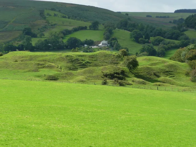
David Medcalf — CC BY-SA 2.0 via Wikimedia Commons licence

Plan your visit
- Typical visit
- 1 h–2 h
- Nearest railway station
- Newtown · 8.9 km
Getting there & planning your visit
To visit Anchor in Mid Wales, the nearest railway station is Newtown, located approximately 8.9 km away. The postcode for your sat-nav is SY7 8PR. Entry details are not specified.
About
Anchor is a place of interest in Wales Mid, United Kingdom — drawn from open-data sources for visitor reference. See the linked Wikipedia article for the full description.
Photo gallery
Heritage listing
http://cadwpublic-api.azurewebsites.net/reports/listedbuilding/FullReport?lang=en&id=4854
From Cadw under OGL v3.
Protected designations
- Area of Outstanding Natural Beauty: Shropshire Hills
Designations sourced from Natural England open data under OGL v3.
From the Wikipedia article
Anchor is a remote hamlet in southwest Shropshire, England. The hamlet is the most westerly place in Shropshire.
Excerpt from Wikipedia under CC BY-SA 4.0. See the source article linked in Sources below.
Background
Description
At the main crossroads was the "Anchor" public house at 1266 ft, the highest pub in Shropshire following the closure of The Kremlin at Clee Hill Village. It had been a pub continuously since at least 1830, until the last landlord retired in 2020, and features in the Mary Webb novel Seven for a Secret (1922) as the "Mermaid's Rest". Static caravans, camping and stabling for horses are available at The Anchorage, just to the south of the Anchor pub. Nearby, to the southwest, is Bryn Amlwg Castle, the remains of an ancient castle.
Sourced from Wikipedia under CC BY-SA 4.0.
- Coordinates
- 52.4576, -3.2156
- District
- Shropshire
- Parish
- Bettws-y-Crwyn
- Postcode
- SY7 8PR
- Parliamentary constituency
- South Shropshire
- Nearest railway station
- Newtown — 8.9 km
Sources
- wikidata: Q3403013 (CC0)
- wikipedia: Anchor, Shropshire (CC BY-SA 4.0)
Other places nearby

The Anchorage
Campsites · 0.2 km
Bryn Amlwg Castle
Castles · 0.9 km

Castle Bryn Amlwg
Castles · 0.9 km

Cefn Fron Hill
Mountains & hills · 1.5 km

Bryn
Mountains & hills · 2.2 km
Bryn
Mountains & hills · 2.2 km

Black Mountain
Mountains & hills · 2.5 km
Black Mountain
Mountains & hills · 2.5 km

Bedran
Mountains & hills · 3.0 km

Pen Hendre
Mountains & hills · 3.2 km

Crug y Byddar
Literary houses · 3.3 km

Cantlin Stone
Memorials & monuments · 3.3 km
Nearby
📷 5📷 3Castles · Mid Wales
Bryn Amlwg Castle
Bryn Amlwg Castle — castle in Bettws-y-Crwyn, Shropshire, England, UK.
📷 5📷 5Mountains & hills · Mid Wales
Cefn Fron Hill
Cefn Fron Hill — mountain in wales mid. Elevation: 413 m.
📷 5📷 5Where to eat & stay near Anchor
Places to stay
📷 5 📷 5
📷 5 📷 5
📷 5Caravan parks · Mid Wales
Cefn Lea Holiday Park
Cefn Lea Holiday Park — a caravan park in wales mid.
 📷 5
📷 5 📷 5
📷 5 📷 5
📷 5Places to eat & drink
 📷 4
📷 4 📷 4
📷 4 📷 4
📷 4Historic pubs · Mid Wales
The Checkers
The Checkers in Wales Mid, United Kingdom.
 📷 7
📷 7Historic pubs · Mid Wales
The Six Bells And Former Stables To Rear
The Six Bells And Former Stables To Rear in Wales Mid, United Kingdom.
 📷 5
📷 5Historic pubs · Mid Wales
The Black Lion And Forecourt Railings
The Black Lion And Forecourt Railings in Wales Mid, United Kingdom.
 📷 7
📷 7More places in this region
 📷 5
📷 5 📷 3
📷 3Other places · Mid Wales
Sheep Music
Sheep Music is a three-day world music festival which takes place during July each year in Presteigne. It has 22 years of history, starting as a party on The Warden in 1991. Since moving to its curren
 📷 2
📷 2 📷 4
📷 4Frequently asked questions
- Where is Anchor?
- Anchor is in Mid Wales, United Kingdom (postcode SY7 8PR), in the parish of Bettws-y-Crwyn.
- What is Anchor?
- Anchor in Wales Mid, United Kingdom.
- How do I get to Anchor?
- The nearest railway station is Newtown, about 8.9 km away. Drivers can use postcode SY7 8PR.
- Is Anchor a listed building?
- Anchor is officially recognised as II listed.
- Is Anchor a protected site?
- Yes — Anchor is part of the Shropshire Hills National Landscape (AONB).
- How do I get to Anchor?
- Drivers can navigate to postcode SY7 8PR. It sits within the South Shropshire parliamentary constituency.