Mountains & hills · Scottish Highlands
An Caisteal
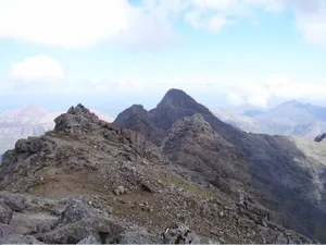
An Caisteal — a hill or mountain in scotland highlands.

Ian Taylor — CC BY-SA 2.0 via Wikimedia Commons licence
Plan your visit
- Typical visit
- 3 h–8 h
- Best time of year
- Late spring – early autumn (May–Oct)
About
A British hill or mountain, named on Ordnance Survey maps and walked by hill-baggers. An Caisteal is a named hill or mountain in scotland highlands, recorded in the GeoNames UK gazetteer. British landmarks of this type are typically marked on Ordnance Survey maps and recorded in the national gazetteer for cartographic and navigational reference. Coordinates and feature classification are sourced from the GeoNames open dataset.
Photo gallery
Place summary
An Caisteal is a mountain located in the Scottish Highlands. It is known for its distinctive profile and is part of the mountain range that includes several notable peaks. The area offers a range of walking trails, attracting hikers and outdoor enthusiasts. Visitors can expect rugged terrain and scenic views typical of the Highlands.
AI-generated from the structured facts on this page (operator, designation, listing, era). Not a substitute for visiting.
- Coordinates
- 57.2401, -6.2100
Sources
- manual: geonames-12612389 (CC BY 4.0)
Other places nearby
Loading nearby places…
Nearby
 📷 5
📷 5Mountains & hills · Scottish Highlands
Bidein Druim nan Ramh
Bidein Druim nan Ramh — a hill or mountain in scotland highlands.
📷 5Mountains & hills · Scottish Highlands
Bidein Druim nan Ramh
Bidein Druim nan Ramh — mountain in scotland highlands. Elevation: 834 m.
 📷 5
📷 5Mountains & hills · Scottish Highlands
Bruach na Frithe
Bruach na Frithe — a hill or mountain in scotland highlands.
 📷 3
📷 3Natural landmarks · Scottish Highlands
Bruach na Frìthe
Bruach na Frìthe — 958m high mountain in Highland, Scotland, UK.
 📷 3
📷 3Mountains & hills · Scottish Highlands
Bruach na Frìthe
Bruach na Frìthe — Named summit at 958 m.
 📷 5
📷 5Mountains & hills · Scottish Highlands
Sgurr an Fheadain
Sgurr an Fheadain — a hill or mountain in scotland highlands.
Where to eat & stay near An Caisteal
Places to stay
 📷 5
📷 5Hostels · Scottish Highlands
Glenbrittle Youth Hostel
Glenbrittle Youth Hostel — a hostel in scotland highlands. Brand: Hostelling Scotland.
 📷 5
📷 5Hostels · Scottish Highlands
Sligachan Bunkhouse
Sligachan Bunkhouse — a hostel in scotland highlands.
 📷 5
📷 5Campsites · Scottish Highlands
Sligachan Campsite
Sligachan Campsite — a campsite in scotland highlands.
 📷 5
📷 5Campsites · Scottish Highlands
Glenbrittle Campsite
Glenbrittle Campsite — a campsite in scotland highlands.
 📷 5
📷 5Hotels · Scottish Highlands
Raasay House
Raasay House — a hotel in scotland highlands.
 📷 5
📷 5Hostels · Scottish Highlands
Skyewalker Hostel
Skyewalker Hostel — a hostel in scotland highlands.
More mountains in this region
 📷 3
📷 3Mountains & hills · Scottish Highlands
A' Bhuidheanach Bheag
A' Bhuidheanach Bheag — Named summit at 936 m.
 📷 3
📷 3Mountains & hills · Scottish Highlands
A' Chailleach
A' Chailleach — Named summit at 997 m.
 📷 3
📷 3Mountains & hills · Scottish Highlands
A' Chailleach
A' Chailleach — Named summit at 930 m.
 📷 3
📷 3Mountains & hills · Scottish Highlands
A' Chaoirnich
A' Chaoirnich — Named summit at 875 m.
Frequently asked questions
- Where is An Caisteal?
- An Caisteal is in the Scottish Highlands, United Kingdom.
- What is An Caisteal?
- An Caisteal — a hill or mountain in scotland highlands.
- How do I get to An Caisteal?
- Its coordinates are 57.2401°, -6.2100°.