
Museums · East Midlands
Alford, Lincolnshire
In or near Hogsthorpe.
Alford is a market town and civil parish in the East Lindsey district of Lincolnshire, England, at the foot of the Lincolnshire Wolds, which form an Area of Outstanding Natural Beauty. The population

JThomas — CC BY-SA 2.0 via Wikimedia Commons licence

Plan your visit
- Typical visit
- 1.5 h–3 h
- Best time of year
- Year-round
- Family-friendly
- Limited wheelchair access
About
Alford is a market town and civil parish in the East Lindsey district of Lincolnshire, England, at the foot of the Lincolnshire Wolds, which form an Area of Outstanding Natural Beauty. The population was recorded as 3,459 in the 2011 Census and estimated at 3,830 in 2021. It lies between the towns of Mablethorpe, Louth, Spilsby, and Skegness and acts as a local retail centre.
Photo gallery
Protected designations
- Area of Outstanding Natural Beauty: Lincolnshire Wolds
Designations sourced from Natural England open data under OGL v3.
From the Wikipedia article
Alford is a market town and civil parish in the East Lindsey district of Lincolnshire, England, at the foot of the Lincolnshire Wolds, which form an Area of Outstanding Natural Beauty. The population was recorded as 3,459 in the 2011 Census and estimated at 3,830 in 2021. It lies between the towns of Mablethorpe, Louth, Spilsby, and Skegness and acts as a local retail centre.
Excerpt from Wikipedia under CC BY-SA 4.0. See the source article linked in Sources below.
Background
History
Alford is mentioned in the Domesday Book as Alforde. There was a settlement at Alford in pre-Norman times and it provided a place to cross the beck. This is intimated in the 'ford' part of its name. The name Alford derives from the Old English ald-ford meaning 'old ford'. The town occupied an important position historically and a charter was obtained by William Well, lord of the manor of Alford, in 1283 for a market to be held on Tuesdays and two annual fairs – one at Whitsun and the other in November. These remained active until 1939 with the bull fair continuing until 1972. A cattle market was established in 1911 but closed in 1987. The railway was opened in 1848 but was closed in 1970…
Sourced from Wikipedia under CC BY-SA 4.0.
- Coordinates
- 53.2600, 0.1800
- County
- Lincolnshire
- District
- East Lindsey
- Parish
- Alford
- Postcode
- LN13 9AD
- Parliamentary constituency
- Louth and Horncastle
Sources
- wikipedia: Alford, Lincolnshire (CC BY-SA 4.0)
Other places nearby

Windmill Hotel
Historic pubs · 0.1 km

Alford War Memorial Cross
Memorials & monuments · 0.2 km
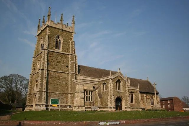
St. Wilfrid's Church, Alford
Historic churches · 0.2 km
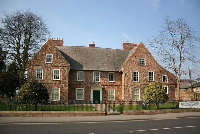
Alford Manor House
Stately homes · 0.2 km

Alford Windmill
Windmills · 0.7 km

Tothby
Vineyards · 1.2 km

Bilsby War Memorial
Memorials & monuments · 1.4 km

Bilsby
Historic churches · 2.0 km

Rigsby
Villages · 2.6 km

Farlesthorpe
Historic churches · 2.8 km

Mawthorpe
Museums · 2.9 km

Saleby
Villages · 2.9 km
Nearby
📷 5📷 3Memorials & monuments · East Midlands
Alford War Memorial Cross
Alford War Memorial Cross — Grade II listed building-listed memorial in england-east-midlands, United Kingdom.
📷 3Historic churches · East Midlands
St. Wilfrid's Church, Alford
St. Wilfrid's Church, Alford — church in Alford, Lincolnshire, England, UK.
📷 3Stately homes · East Midlands
Alford Manor House
Alford Manor House — Independent Museum in the East Midlands, United Kingdom.
📷 3📷 5Vineyards · East Midlands
Tothby
Tothby — a UK vineyard in england east midlands, producing English or Welsh wine from cool-climate grape varieties.
Where to eat & stay near Alford, Lincolnshire
Places to stay
 📷 5
📷 5Caravan parks · East Midlands
Sunny Ridge caravan park
Sunny Ridge caravan park — a caravan park in england east midlands.
 📷 5
📷 5Campsites · East Midlands
The Nurseries Caravan Site
The Nurseries Caravan Site — a campsite in england east midlands.
 📷 5
📷 5Campsites · East Midlands
Olcote Farm Touring Caravan Site
Olcote Farm Touring Caravan Site — a campsite in england east midlands.
 📷 5
📷 5Caravan parks · East Midlands
Lakeside Springs Caravan Park
Lakeside Springs Caravan Park — a caravan park in england east midlands.
 📷 5
📷 5Caravan parks · East Midlands
Jolly Common Caravan Park
Jolly Common Caravan Park — a caravan park in england east midlands.
 📷 5
📷 5Caravan parks · East Midlands
Willows Caravan Park
Willows Caravan Park — a caravan park in england east midlands.
Places to eat & drink
📷 5 📷 5
📷 5Historic pubs · East Midlands
Massingberd Arms
Massingberd Arms in England East Midlands, United Kingdom.
 📷 5
📷 5 📷 5
📷 5 📷 5
📷 5More museums in this region
 📷 5
📷 5Museums · East Midlands
Stamford Town Hall
Stamford Town Hall — building in Stamford, Lincolnshire, England, UK.
 📷 5
📷 5Museums · East Midlands
Thorney Museum
Thorney Museum — a museum in england-london, United Kingdom.
 📷 5
📷 5Museums · East Midlands
Octavia Hill Birthplace Museum
Octavia Hill Birthplace Museum — a museum in england-london, United Kingdom.
 📷 5
📷 5Museums · East Midlands
Museum of Technology
Museum of Technology — a museum in england-london, United Kingdom.
Frequently asked questions
- Where is Alford, Lincolnshire?
- Alford, Lincolnshire is in Lincolnshire, the East Midlands, United Kingdom (postcode LN13 9AD), in the parish of Alford.
- What is Alford, Lincolnshire?
- Alford is a market town and civil parish in the East Lindsey district of Lincolnshire, England, at the foot of the Lincolnshire Wolds, which form an Area of Outstanding Natural Beauty. The population
- How do I get to Alford, Lincolnshire?
- Drivers can use postcode LN13 9AD.
- Is Alford, Lincolnshire a protected site?
- Yes — Alford, Lincolnshire is part of the Lincolnshire Wolds National Landscape (AONB).
- How do I get to Alford, Lincolnshire?
- Drivers can navigate to postcode LN13 9AD. It sits within the Louth and Horncastle parliamentary constituency.