
Archaeological sites · South West England
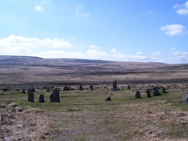
A partly enclosed stone hut circle settlement on Kennon Hill
In or near Gidleigh.
A partly enclosed stone hut circle settlement on Kennon Hill — archaeological site in Throwleigh, West Devon, England, UK.

Wikimedia Commons contributors — see linked file page for photographer and licence licence

Plan your visit
- Typical visit
- 45 min–1.5 h
- Nearest railway station
- Okehampton · 7.3 km
- Free entry
- Dog-friendly
About
A partly enclosed stone hut circle settlement on Kennon Hill is a place of interest in South-West England. Officially recognised as scheduled monument. The site is a designated Site of Special Scientific Interest. The nearest railway station is Okehampton, about 7.3 km away.
Photo gallery
Protected designations
- Site of Special Scientific Interest: North Dartmoor SSSI
Designations sourced from Natural England open data under OGL v3.
Place summary
A partly enclosed stone hut circle settlement located on Kennon Hill in South-West England. This archaeological site is designated as a scheduled monument and is part of the North Dartmoor Site of Special Scientific Interest (SSSI).
AI-generated from the structured facts on this page (operator, designation, listing, era). Not a substitute for visiting.
- Coordinates
- 50.6851, -3.9243
- Nearest railway station
- Okehampton — 7.3 km
Sources
- wikidata: Q17665930 (CC0)
- commons: Kennon Hill settlement remains - geograph.org.uk - 1499136.jpg (CC BY-SA 4.0)
Other places nearby

Kennon Hill
Mountains & hills · 0.3 km

Rival Tor
Mountains & hills · 1.0 km

Stone circle and cairn
Stone circles · 1.1 km

Stone circle and cairn
Archaeological sites · 1.1 km
Little Hound Tor
Mountains & hills · 1.3 km

Cawsand Beacon
Mountains & hills · 1.8 km

Metheral Hill
Mountains & hills · 1.8 km
Scorhill
Hill forts · 2.1 km

Scorhill Stone Circle
Stone circles · 2.1 km

Higher Shilstone Farmhouse Including Stables And Garden Walls Adjoining To South
Gardens · 2.2 km

Wallabrook Bridge
Historic bridges · 2.3 km

Wild Tor
Mountains & hills · 2.3 km
Nearby
📷 5Mountains & hills · South West England
Kennon Hill
Kennon Hill — mountain in england south west. Elevation: 478 m.
📷 5Mountains & hills · South West England
Rival Tor
Rival Tor — mountain in england south west. Elevation: 421 m.
📷 3Stone circles · South West England
Stone circle and cairn
Stone circle and cairn — a stone circle in england-south-west, United Kingdom.
📷 5Archaeological sites · South West England
Stone circle and cairn
Stone circle and cairn — archaeological in england south west.
📷 5Mountains & hills · South West England
Little Hound Tor
Little Hound Tor — mountain in england south west. Elevation: 500 m.
📷 5Mountains & hills · South West England
Cawsand Beacon
Cawsand Beacon — a hill or mountain in england south west.
Where to eat & stay near A partly enclosed stone hut circle settlement on Kennon Hill
Places to stay
 📷 5
📷 5Campsites · South West England
Elvan Farm Pop-up Campsite
Elvan Farm Pop-up Campsite — a campsite in england south west.
 📷 5
📷 5Hotels · South West England
Gidleigh Park
Gidleigh Park — a hotel in england south west.
 📷 5
📷 5Caravan parks · South West England
Dartmoor View Holiday Park
Dartmoor View Holiday Park — a caravan park in england south west.
 📷 5
📷 5Caravan parks · South West England
Woodland Springs Adults only Touring Park
Woodland Springs Adults only Touring Park — a caravan park in england south west.
 📷 5
📷 5Hotels · South West England
The Three Crowns Hotel
The Three Crowns Hotel — a hotel in england south west.
 📷 5
📷 5Places to eat & drink
 📷 5
📷 5Historic pubs · South West England
The Oxenham Arms
The Oxenham Arms in England South West, United Kingdom.
 📷 7
📷 7Historic pubs · South West England
Warren House Inn
Warren House Inn in England South West, United Kingdom.
 📷 5
📷 5 📷 5
📷 5Historic pubs · South West England
Tom Cobley Tavern
Tom Cobley Tavern in England South West, United Kingdom.
 📷 7
📷 7Historic pubs · South West England
White Hart Hotel
White Hart Hotel in England South West, United Kingdom.
 📷 5
📷 5Historic pubs · South West England
Kings Arms Inn
Kings Arms Inn in England South West, United Kingdom.
More archaeological sites in this region
 📷 5
📷 5Archaeological sites · South West England
Battlesbury Camp Monuments: hillfort, settlement, cemetery, barrows, enclosure, and field systems
Battlesbury Camp Monuments: hillfort, settlement, cemetery, barrows, enclosure, and field systems — archaeological site in Warminster, Wiltshire, England, UK.
 📷 5
📷 5Archaeological sites · South West England
Blandford Forest
Blandford Forest — forest in Blandford Forum, England.
 📷 5
📷 5Archaeological sites · South West England
Boulsbury Wood
Boulsbury Wood — protected area in Dorset and Hampshire, England.
.jpg?width=1200) 📷 5
📷 5Archaeological sites · South West England
Cranborne Chase
Cranborne Chase — Plateau in southern England.
Frequently asked questions
- Where is A partly enclosed stone hut circle settlement on Kennon Hill?
- A partly enclosed stone hut circle settlement on Kennon Hill is in South-West England, United Kingdom.
- What is A partly enclosed stone hut circle settlement on Kennon Hill?
- A partly enclosed stone hut circle settlement on Kennon Hill — archaeological site in Throwleigh, West Devon, England, UK.
- How do I get to A partly enclosed stone hut circle settlement on Kennon Hill?
- The nearest railway station is Okehampton, about 7.3 km away. The nearest town is Gidleigh. Its coordinates are 50.6851°, -3.9243°.
- Is A partly enclosed stone hut circle settlement on Kennon Hill a listed building?
- A partly enclosed stone hut circle settlement on Kennon Hill is officially recognised as scheduled monument listed.
- Is A partly enclosed stone hut circle settlement on Kennon Hill a protected site?
- Yes — A partly enclosed stone hut circle settlement on Kennon Hill is part of the North Dartmoor SSSI Site of Special Scientific Interest.
- Is A partly enclosed stone hut circle settlement on Kennon Hill free to visit?
- Yes, A partly enclosed stone hut circle settlement on Kennon Hill is free to enter.
- How do I get to A partly enclosed stone hut circle settlement on Kennon Hill?
- The nearest railway station is Okehampton, about 7.3 km away.